Water. It had transformed this hike. We slept beside creeks, we could hear the water trickling. It was the first signigicant season for rain in 10 years, the greenest the area had looked in 20 years.
Arkaroola to Angepena, 11/4/10 to 15/4/10
The water almost kept us out. We had been monitoring the rainfall, there had been good rain in November, December and February. But as we packed our things on Thursday night and drove up Friday morning more rain fell, 80mm in Arkaroola and 100mm in Leigh Creek. By the time we reached Hawker all the dirt roads north of Blinman had been closed, the bitumen road to Copley closed shortly after. Waiting between road status reports, we did a short hike up Illuka Hill in Wilpena Pound.
Saturday night at the Hawker pub we were despondant. The roads remained closed, the extent of road damage was becoming clear, the roads wouldn't be reopening anytime soon. We were locked out of the best walking season in 20 years in the Gammons. We had missed out by just half a day from being able to enter, closed roads wouldn't affect us when we were walking.
 A plan was hatched. Calls were made, deals done. We chartered a plane from Rawnsley Park to Arkaroola. We would hike in reverse, south-west back to Angepena instead of north-east to Arkaroola from Angepena. From Angepena we would get a 4WD tour operator to pick us up and drive us back to our cars at Rawnsley Park. After five days of walking the roads were sure to be open to allow the 4WD tour operator to access us. The flight and transfers came to just under $400 each. It was a unique time to walk in the Gammons, so we seized the opportunity.
Our plane trip took us over flooded creeks, a good sign as we were relying on creeks as our water source. From the Arkaroola airstrip we were driven to Arkaroola Village by Doug Sprigg and his son, an informative commentary along the way. It transpired he would have flown down and picked us up for a lot less than what we had paid as he is a smaller operator than the Rawnsley Park one.

After a last meal at Arkaroola, a pasty and chips, we set off on our five day trek into the Gammons and south to Angepena Station. We had quite some miles to cover on this first day as we had not departed until after lunch, as it was we raced the sun into camp. It was spectacular walking through the sunset. Yeah, it felt like we walked through it, we did not merely see it. It surrounded us, I spent quite some time walking looking at the clouds above me. There were three levels of clouds, each reflecting a different sunset colour. The higher wispy clouds shone orange, higher clouds shone bright yellow, the lower ones in shade. All this interspersed with patches of bright sky blue sky.
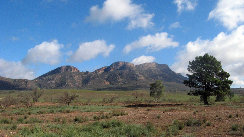
 For five days we marvelled at how green everything was, months of good rainfall ensured the green extended everywhere. I hadn't been in the Gammons before, but it is similar to the Flinders, indeed, the rainfall is usually lower, and right now this land stood in stark contrast to the normal Flinders scene. The bright red rocky ground was covered in green vegetation.
With the recent rains creeks flowed, at our first campsite, Mainwater Well, the creek flowed past us as we slept. Surreal to hear trickling water. Walking along creeks we had to negotiate mud and debris, and something rarely required in South Austalia, we had to walk along some wet creeks in ankle deep water!
On our second day we made camp by midday, again by Mainwater Creek. Leaving our gear and heavy packs we climbed Benbonyathe Hill. The climb wasn't complex, but the vegetation, especially near and along the ridgetop, was dense. Lower down it was easy enough to walk through. Reaching the summit and the stone cairn, we found a primitive steel frame for setting up a telescope. In the 1960s the British and Americans sought out possible sites to set up a telescope, both Benbonyathe Hill and Mount Mackinlay were tried. A rough road was constructed up each. On our hike along the ridge we saw no sign of the road, fragments of it were allegedly still visible some years ago, although the road came from the south before travelling along the ridge, we had hiked up from the north before going along the ridge. The site chosen for the observatory was Siding Springs in NSW.
 In the logbook at the summit we found a note left in 1986 by a school undertaking the Jubilee Trek. This was a trek undertaken from Mount Babbage, north of Arkaroola, to Cape Jervis. Each school did a section, this was done prior to the completion of the Heysen Trail. Just last week, upon returning from Kangaroo Island I had first heard of this walk, reading a plaque at Cape Jervis near the ferry terminal.
For the second and third day we followed Mainwater Creek through Mainwater Pound. After navigating through the pound using our map reading and dead reckoning skills using the GPS only as a double check, we made our way up a side creek to Yackie Waterhole to collect some water. From here we climbed out of the pound, camping up at Arcoona Saddle. We selected the best spot we could in the saddle to camp, clearing rocks and branches.

The following day we hiked along the ridgetops, seeing many campsites more suitable than the one we had camped at. A short distance from Gammon Hill we dropped our packs to reach the summit. Gammon Hill was an easy walk, the gradient is easy and the vegetation wasnt dense. Here we found the logbook canister, but it was empty for all but one note. It seemed the last people here had removed the contents in order to transcribe them, promising to return them soon.
From Gammon Hill we chased some goats along the ridgetops, passing by Arcoona Saddle before rapidly descending back to the plains and our campsite at Arcoona. Refreshed with tank water from the car accessible campsite, we made our plans for our final day.
Our last day we walked through Owieandana Station, recently purchased by Operation Flinders, sighting our first person in five days. We stopped by Painter's Baseline, a cairn erected by a surveyor in 1857 and used to undertake the first surveys on the area.
Reaching Angepena Station we found that the road out to Copley remained closed, but 4WD vehicles were using the road. We arranged our pick-up for first thing the next morning, and made ourselves comfortable in the newly restored Shearer's Quarters of the station, enjoying another spectacular sunset and star filled sky.
More photos to come from Nick and Graham
Download kml file to view in Google Earth or adapt to use as a navigational aid in a GPS unit |
Download our walking route drawn onto topographic maps.
| Stats | Beyond the Heysen: Stage 2 - Arkaroola to Angepena | |||||
| Sunday | Monday | Monday | Tuesday | Wednesday | Thursday | |
| 11/4/2010 | 12/4/2010 | 12/4/2010 | 13/4/2010 | 14/4/2010 | 15/4/2010 | |
| Arkaroola Village to Mainwater Well | Mainwater Well to Mainwater Creek | Mainwater Creek to Benbonyathe Hill & return | Mainwater Creek to Arcoona Saddle | Arcoona Saddle to Arcoona campsite | Arcoona campsite to Angepena | |
| Distance | 20.5km | 7.4km | 9.4km | 14.6km | 16.3km | 22.9km |
| Start Time | 12:56pm | 8:17am | 12:22pm | 8:19am | 8:23am | 8:25am |
| End Time | 6:29pm | 11:46am | 5:12pm | 4:29pm | 5:15pm | 3:17pm |
| Moving Duration | 4h39m | 2h18m | 3h09m | (5h11m) | 6h04m | 5h00m |
| Stationary Duration | 58m | 55m | 1h18m | (50m) | 2h45m | 1h51m |
| Moving Average | 4.4km/h | 3.2km/h | 3.0km/h | 3.1km/h | 2.7km/h | 4.6km/h |
| Overall Average | 3.6km/h | 2.3km/h | 2.1km/h | 1.8km/h | 1.8km/h | 3.3km/h |
| Oodometer | 20.5km | 27.9km | 37.3km | 51.9km | 68.2km | 91.1km |