Wednesday, July 28, 2010

Nitmiluk National Park (Katherine Gorge)

Occasionally, although thankfully, rarely, things can go horribly wrong on a hike. No, not an injury, getting lost, or even the much feared snake bite or croc encounter. One can run out of reading material. Even those who have meticulously packed for their hike, including not one, but two books, can be caught short. I completed both my books during the long, lazy afternoons at each campsite.

Nitmiluk National Park (Katherine Gorge), Northern Territory


Maybe not horribly wrong, but as those of you who are fellow book lovers, this isn't a situation one wants to find oneself in. I had tried to fill my days with hiking, picking the furthest campsites with the most difficult trail ratings. As you might know, I waste no time in walking. I completed each day's hiking within four hours. The first day, this wasn't so much of a problem as I only started out at 10am. The second day though, I was eating an early lunch atop the cliff's edge overlooking Katherine Gorge and my night's campsite.

I could have done all the walking in two, not three, days, but I wanted to give my ever-injured feet a break, and to enjoy each of the spectacularly placed campsites on the Katherine River.


The day before my hike the Katherine River was closed to swimmers and canoeists due to a saltie sighting. A canoeist had seen what they thought looked awfully like a saltie, and not a freshie. Two days later, the rangers confirmed it. As is their way, the saltie had moved up the river undetected. It was only a little fella, only two metres in length, but still, it wouldn't pass up the opportunity to have a bit of a nibble on a German or Japanese tourist. It had snuck past the main swimming and boating area near the visitor centre, over the first set of rapids and into the second gorge.

There was no danger to my planned hike, or so I was assured. The croc still had to cross a few more sets of rapids to reach my swimming and camping spots. Even so, the thought plays on one's mind as one swims in the river. These crocs can move about undetected, let's not forget that.

I walked first to the Eighth Gorge, not deviating down any of the side trips from the main east-west track. The network of walks here is referred to as the Southern Walks of the Nimiluk (Katherine Gorge) National Park. It presents many options - one main track leads end-to-end, many side tracks lead down to the gorge and river. Several weeks ago I had walked a day hike into Butterfly Gorge and Pat's Lookout with Beni - at the time we had been limited to day walks as we needed to check daily at the post office to see if the new radiator for the crippled car had arrived.

Butterfly Gorge is not so special. There are butterflies, true, but they aren't of particular interest. The monsoon forest here has been blackened by recent bushfires. The river's edge is somewhat inaccessible. Returning from out walk here, we diverted down another side track to Pat's Lookout and the Southern Rockhole. The lookout has panoramic views over the river from the cliff edge. We also enjoyed a nice swim in the river, not put off by the signs on the opposite side of the river stating, "Warning. Do not enter beach. Croc breeding ground." They were, of course, only harmless freshies.

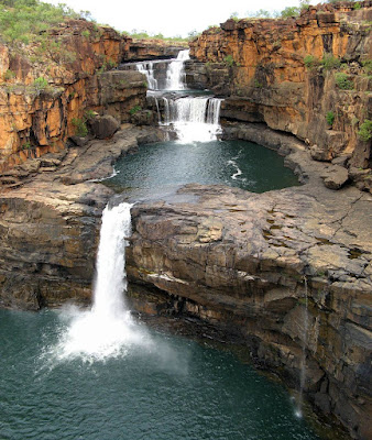
Eighth Gorge is special. The campsite is beside a large plunge pool with waterfall. The river can be found by following the trickle of water leaving the pool's edge, growing to a creek, before it itself tumbles over the cliff edge to the Katherine River far below.

On the second day, I returned along some of the main track, but this time deviating into Jawoyn Valley. The indig rock art was hard to find, I suspect I found very little of it, but the views and surroundings were pleasant so the detour was well worth it.

Returning to the main track, I took another side track, this time to Smitt Rock where I would spend the afternoon and camp. Naming the place a rock is quite an understatement. The river is split in two by the huge rock formation, it as high as the surrounding cliffs. The campsite sits on the sand banks of the river. I had this campsite, like the previous night's, all to myself. There were no other hikers, and no-one was permitted to canoe up the river to join me. Pity, it was a wonderful place to spend a warm afternoon reading in the shade of a nice gum tree.


Download kml file to view in Google Earth or adapt to use as a navigational aid in a GPS unit


Stats

Southern Walks of Nitmiluk (Katherine Gorge) National Park
Monday Tuesday Wednesday
26/7/2010 27/7/2010 28/7/2010
Nitmiluk Visitor Centre to Eighth Gorge Eighth Gorge to Smitt Rock via Jawoyn Valley Smitt Rock to Nitmiluk Visitor Centre
Distance 15.65km 15.5km 10.8km
Start Time 9.50am 8.10am 7.38am
End Time 2.10pm 12.40pm 10.06am
Moving Duration 2h55m 3h10m 2h08m
Stationary Duration 1h07m 1h23m 19m
Moving Average 5.4km/h 4.7km/h 5.0km/h
Overall Average 3.6km/h 3.3km/h 4.4km/h
Oodometer 15.65km 31.7km 42.1km

Sunday, July 25, 2010

Table Top Track - Litchfield

My main interest in Litchfield National Park was the 39 kilometre Tabletop Track. However the park was so good, and the offer of a friend to come down and join me for the weekend from Darwin was too good to refuse, so I stayed on for another three days.

Litchfield National Park, Northern Territory


The Tabletop Track is a loop walk, accessible from several different link walks that connect to car based campgrounds or natural attractions. So even though it is a 39 kilometre walk, one has to walk further to access the track, and further still to take in some of the side trips the natural attractions such as the rock holes and waterfalls. Well, if, and I mean IF, one can cope with walking during the day seeing almost no-one, then walking down a side track to a waterfall which has seemingly just been inundated with several tourist buses worth of people, each armed with an SLR camera and complaining about how tiring the three hundred metre walk from the carpark is.

Florence Falls is one of the more famous sites in Litchfield National Park, perhaps only Wangi Falls rivals it. I did the two kilometre side trip to Florence Falls, the link walk taking me through a humid monsoon tropical forest to the spectacular falls with a large, cool plunge pool. Somehow I quite accidentally managed to get a photo with no-one in it, how I don't know, as I swam another tourist bus load of people arrived.

The following day though, I couldn't bear to repeat the people inundation experience at Wangi Falls, so I skipped this side trip. I did return in the following days though with my friend from Darwin, and there were so, so many people, but it was still good, maybe helped by his tales of visiting Wangi during the Wet. No people there then, just lots of water and maybe lots of crocs lurking around too.

Much of what is easily accessible in Litchfield National Park, including the Tabletop Track, lies in the north of the park. The Tabletop Plateau dominates, the roads skirt around the plateau following the escarpment edge, frequent short roads in to the many waterfalls and water holes. The Tabletop Track likewise follows much of the escarpment, but on the plateau well away from the road and people. While most of the waterfalls are accessible by these short roads, some are only accessible from the Tabletop Track, which is what makes this track so special.


The walking in the savanna was hot, I really should have done the walk over more days and restrict my walking to the cooler mornings. The monsoon forests and many creeks and waterfalls though were so much cooler to walk through, always a nice place to sit and relax, maybe swim.

One campground was particularly special, only a very short walk from a link walk car park, each campsite with it's own private bit of creek, rock pool and waterfall. But if I tell you it's name I will have to kill you. So if you email me or leave a comment asking me, I will need to send a hit man around. And that wont be very pleasant, now will it? I would like to keep the Best Ever Campsite a secret as much as possible, although I shared it with my Darwin friend and I decided I would let him live (he was, after all, rather nice to talk to).

I lost my much loved and travelled hiking GPS unit, an insurance agent slammed into the back of my car on the highway, and I accidentally took too much of what I like to call my Deadly Drug (a medication), but these are all stories for another time...

Sorry, no map from the GPS for you this time. Too bad heh, you won't be able to find the secret campsite unless you come up here and explore it for yourself.

Updated 25/05/2011. There are GPS files available for this walk now. They come from https://en.travelnt.com/experience/walking-trekking/tabletop-track.aspx - I reconfigured the XML file as a GPX file and KML file. The path doesn't have a huge amount of points, but should be ample for navigating the trail should you wander off it (really only possible through burnt out areas of wide creek crossings.) I would place a caveat on the area around Walker Creek though, I'm not sure it looks correct, the trail goes from the main trail west to Walker Creek Campsite as a spur trail rather than the main trail passing through the carpark. If coming off the main trail you won't get lost, the spur meets to the carpark to campsites trail near the toilet, at about campsite 6 of 8. Turn left for sites 6-8, right for sites 1-5 and carpark.

Download GPX file - for use as a navigational aid in a GPS unit
Download KML file - view in Google Earth


View in full screen format
The above Google Map shows the official trail file from TravelNT.com
Download GPX file
- for use as a navigational aid in a GPS unit
Download KML file - view in Google Earth

Saturday, July 10, 2010

The Bungle Bungle

Although known to local pastoralists and indigenous folk, the Bungle Bungle was unknown to the outside world until the mid 1980s. It did not appear on maps - not even topographical maps - nor was it photographed, not even named. A helicopter camera crew discovered it by accident, making it's dramatic scenery known to Australians and the rest of the world.

The Bungle Bungle, Purnululu National Park, WA


The local pastoralists saw it only as a source of a river, the business of cattle kept them occupied. Gold was discovered in nearby Halls Creek in the 1880s, but still the Kimberley held the secret of the Bungle Bungle. To the indigenous folk it had special meaning, but we know they like to keep their secrets sometimes, and why not?

If I share, too many white men will come all right, and they will go on doing this. Sticky beak all right, and look for something. If they find something goody goody, they'll take it.

-- source: interview on ABC's Stateline, 28/5/2010, concerning rockart in Kakadu (url https://www.abc.net.au/news/video/2010/05/28/2912636.htm)

Some stuff is still a well guarded secret by the indigenous folk. Their rock art, which includes depictions of crocodiles, and burial sites.


This is one of the iconic places I wanted to visit on my four month trip, I think you will see why in some of the photos. To enter Cathedral Gorge one is filled with awe. Walking through a narrow gorge, the shear cliffs towering 200 metres above on each side. The gorge floor is occupied by a flat creek. It feels like you are about to stumble upon an ancient city in the desert, Petra maybe. Not a noise can be heard, it's one of the places in the world that seems to call for silence. Walking several hundred metres through this narrow space, the gorge suddenly opens up, revealing a huge amphitheatre formation. The area, made round by rolling boulders as the water runs down the cliff above, open to the sky in a narrow opening. The middle occupied by a shallow pond, a reminder of how much water would be here during the wet season. The roof ceiling provides a perfect environment for your echo, the place calls for silence but at the same time wants sounds to reverberate around it's walls.

Naturally the Bungle Bungle has more to reveal than just this one special place. The drive from Kununurra down Highway One is spectacular in itself, but it is merely setting the scene for the Bungle Bungle. The 50km 4WD road in from the highway hints a little more, only very close to the park does one see for the first time the mountains of the Bungle Bungle. The orange cliffs rise abruptly from the plains. Dramatic as they are though, they are not the Bungle Bungle one sees in photos. It is only when you drive further in, or better still, walk further in, that one sees their iconic and true beauty -- the stripped beehive formations. These are the most exceptional examples of sandstone cone karsts anywhere in the world. Standing up to 250 metres tall, they create an intricate maze of twists and turns, almost a city of rock sky-rises (to borrow a phrase from the national park literature.)

The sandstone is an ancient riverbed, uplifted high above the surrounding plains. Weathering and erosion slowly formed the distinct shapes we know today, as new rivers were formed through the old riverbed. The sandstone is sedimentary, layers of gray or orange rock. The grey rock has a high clay and moisture content, allowing cyanobacteria to grow on the surface. The orange bands have a lower clay and hence moisture content, preventing the cyanobacteria from growing. This layer oxidises forming the distinct rusty orange colour. Occasionally recent landslides reveal the true colour of this band - a bright silver white colour.

It was through this that we undertook a two day hike. If we did not have a new radiator awaiting collection in Katherine, to be fitted to the crippled car, I think we would have spent three days on this hike. We spent a day hiking along the Piccaninny Gorge, camped beside a rock pool, then hiked back. Had we a third day, we could have explored some of the five side gorges that are present in the upper gorge beyond our campsite. Although only a 14 kilometre hike in, it is a difficult hike. Following the creekbed, it is either sandy, soft gravel, navigating eroded rocks or large boulders.

On the first day we had lunch at the distinct Elbow in the gorge, well, so we thought, until we came upon a more distinct Elbow further upstream. It really was slow walking.

We had the gorge almost to ourselves, beyond the tourist bus groups near the very start of the gorge we passed only two other parties. Both had chosen to hike in and out in a single day, both were jealous we would have so much time to explore and have such a magnificent campsite. The campsite we chose - we could camp anywhere we liked - was beside a rockpool. Cliffs soared high above us, the rockpool being in the corner of the gorge. During the Wet water would cascade down the cliff, filling the rockpool and overflowing into the main gorge creek.

During the day the gorge was filled with a cacophony of bird sounds, echoing up and down the gorge. As night fell, silence descended. Our voices could be heard echoing far up and down the gorge, in the silence we could finally appreciate how far the echo travelled. Our campsite was fitted with a security device, not that it was needed in this isolated place. The cliffs the other side of the rock pool amplified the sounds from the main gorge creek, we could easily have heard footsteps as they approached from either upstream or downstream.

After the hike, we visited nearby Echidna Chasm. We had missed the best time of day to visit, the narrow chasm, sometimes only shoulder width wide, was best seen at true noon, the only time the sun could shine down into the narrow space. The chasm is a fracture in the rock mountain, snaking it's way from the palm entry deep into the mountain, gradually narrowing until it's eventual abrupt end.


Download kml file to view in Google Earth or adapt to use as a navigational aid in a GPS unit


Stats

Piccaninny Gorge, Bungle Bungle, Purnululu National Park
Wednesday Thursday
7/7/2010 8/7/2010
Carpark to Gorge 1 Gorge 1 to carpark
Distance 15.2km 13.1km
Start Time 9.27am 7.33am
End Time 2.52pm 11.27am
Moving Duration 3h33m 3h02m
Stationary Duration 1h56m 56m
Moving Average 4.3km/h 4.3km/h
Overall Average 2.8km/h 3.3km/h
Oodometer 15.2km 28.3km

Monday, July 5, 2010

Mitchell Falls


The Gibb River Road cuts through the heart of the Kimberley. It is a 4WD dirt road. True, it is possible to drive a 2WD on it, we saw two in ten days - countless 4WDs though. Thing is, the two wheel drivers, they will see almost nothing. The attraction is not the road, it is the various rough 4WD tracks that lead off to gorges, waterfalls and pools. These tracks are rough, but every one is worth travelling down.

Mitchell Falls, Mitchell Plateau, The Kimberley, Western Australia


The track to Mitchell Falls is some 250km long and takes about five hours to drive. Walking a further 3.5 kilometres from the carpark one is struck by the immensity of the falls, cascading down from the river into three lower pools.

The 8.6km return hike on the Punamii-Unpuu Trail leads to Mitchell Falls, via Little Mertle Falls with the indigenous rock art behind the waterfall, and Big Mertle Falls.

View full Gibb River Road photo album and blog post.