Tuesday, March 27, 2012

Mt Bogong, #5 of the State 8

A 700-metre ascent from a humid, fern-filled valley onto an alpine summit could not be more of a contrast. Mt Bogong, Victoria’s highest peak at 1968 metres, lies in the Victiorian Alps near the 50s town of Mt Beauty.

Mt Bogong, the High Country, Victoria


The final of three blog entries for a week spent around Canberra doing three of the State 8 peaks - the highest mountains in each of Australia's eight states and territories.


SUMMARY - Mt Bogong hike
Start Mountain Creek Picnic Area
End Mt Bogong summit, re-trace steps to Mountain Creek Picnic Area
Time 3h15m up, 2h30m down
Distance 7km each way
Elevation gain 1370m
Topographic maps 1:30 000 scale, T8324-1-3-S

The alpine environment of Mt Bogong was quite different from the alpine environment of Mt Kosciuszko. Bogong has quite a lot of prominence, how much it rises above country around it. So the alpine area around the summit is small, contrasting with the large alpine area that surrounds the rather indistinct Kosciuszko.

Mt Bogong was the third peak on the week’s list of the State 8 summits – the highest peak in each of Australia’s eight states and territories.

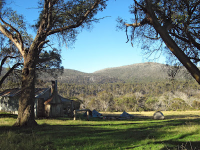
Starting from Mountain Creek Picnic Area, we hiked up the aptly named Staircase Spur. The most direct route, so the steepest, with a few short sections that taper off the constant ascent. We hiked up in the warm, humid afternoon to the halfway point, Bivouac Hut. The noisy school kids didn’t put us off for long, we set up our tents in the large clearing beside the hut – the hut itself is quite small and designed for emergency use. It does have a wood heater though, and a water tank. We did try and look further afield for some tent spots, but being on a steep spur halfway up a mountain meant there were limited camping options, so we settled down with the teenagers instead. Lightning rolled around us the sun set, but we sat outside cooking dinner as the rain spared us.

The following morning, with the summit shrouded in mist, we set off again to the top. Conditions changed as we got higher, we walked past the treeline into the cool breeze, and then into the mist. Nearing the summit paths led off to the right, but in the mist it may have been certain death, so we continued along the snow poles to the ridge, then walked the short distance to the summit. Marked by a large stone cairn which provided us with shelter from the strong, cold winds, Vicki did her little summit jig. We were thankful we had brought along extra clothes, not needed back near the hut but a life-saver up here. A small blue spot emerged through the clouds in the sky above us, but we soon gave up on waiting for any clearing of the weather, and instead started heading back down.

Finishing back at the cars Mountain Creek Picnic Area, we sniffed out a dozen tents that appeared, absent of people and cars, before enjoying a swim in the freezing waters of the creek.


View in full screen format
Download GPX file - for use as a navigational aid in a GPS unit
Download KML file - view in Google Earth


TRACK NOTES - Mt Bogong

Download larger version of track notes
Label Grid Ref Location Note
1 225 383 Mountain Creek Picnic Area, carpark lawned area beside creek, picnic tables, carpark, toilet
2 242 383 Base of Staircase Spur 30 mins from carpark
3 263 368 Bivouac Hut Small hut with stove, water tank, nice toilet, camping area. 1h30m from base of spur (1), 2h from carpark (1). 4km from carpark (1).
4 Treeline
5 Memorial
6 Ridge junction Turn west for summmit, east for Eskdale Point
7 273 347 Mt Bogong summit Marked by cairn, 1h15m from Bivouac Hut (3), 2h45m from base of spur (2), 3h15m from carpark (1). 7.1km from carpark (1).

Saturday, March 24, 2012

Mt Kosciuszko, #4 of the State 8

Mt Kosciuszko, Australia’s highest peak at 2228 metres, sits in the midst of an alpine area. The summit itself is not particularly prominent, the walk in from Charlottes Pass is a gentle steady ascent. It is along an old road, closed in the 60s, which led close to the summit.

Mt Kosciuszko, Kosciuszko National Park, New South Wales


The second of three blog entries for a week spent around Canberra doing three of the State 8 peaks - the highest mountains in each of Australia's eight states and territories.


SUMMARY - Mt Kosciuszko hike
Start Charlottes Pass, end of Mt Kosciusko Road from Jindabyne
End Mt Kosciusko summit, re-trace steps to Charlottes Pass
Summit Walk
Time 1h45m one-way
Distance 9km each way
Elevation gain 390m
Mt Townsend from Main Range Track
Time 1h one-way
Distance 2.5km each way
Elevation gain 100m
Main Range Track
Time 2h45m one-way
Distance 12.7km each way
Elevation gain 390m
Topographic maps 1:25 000 scale, Perisher Valley 8525-2S

The summit is visible from Charlottes Pass, but can be difficult to identify. Charlottes Pass is at the end of the bitumen road, not surprisingly it is Australia’s highest town. Town might be a bit too much to attribute to it, it is a ski resort with a collection of ski lodges. We were able to stay in one lodge, the Pygmy Possum Lodge, with our keen alpine hiker lodge host, Ziggy.

Following the dirt road to the summit from Charlottes Pass, we crossed the infamous Snowy River, a mere few hundred metres from the headwaters. Passing an old stone hut, Seamans Hut, we got our first definitive glimpse of the summit of Kosciuszko.

After an obligatory stop at Australia’s highest toilet, located at the track junction with the ridge Boardwalk that comes from the ski-lift at Thredbo, and where the road used to end at a carpark, we continued on the short distance to the summit.

In the sun Vicki and Shea did a jig (oops no sound), and we sheltered on the leeward side of the summit cairn to eat lunch.

From here the easy hiking ended. We returned to Charlottes Pass via the Main Range Track, diverting off track to the summit of Mt Townsend. It wasn’t really off-track, a foot track marked by stone cairns led from the Main Range Track to the summit. Mt Townsend used to be called Mt Kosciuszko, and Mt Kosciuszko called Mt Townsend. After being named surveys revealed that the now-named Mt Kosciuszko was higher than the previously named Mt Kosciuszko (Mt Townsend), so instead of re-educating people as to the name of the Australia’s peak, they simply swapped the names.

A short cut back from the summit of Mt Townsend to the Main Range Track saw us skirt around Muellers Peak with views of Albion Lake. Back on the Main Range Track we were triumphantly welcomed into the Blue Lake Junction by Vicki and Jack, who had gone ahead and waited for us. Rather exhausted, we plodded on down the valley, crossing the cold waters of the Snowy again, and up the other side to Charlottes Pass.

The following day, eager for a rest of sorts, we did a half-day hike from Charlottes Pass, off track up to Blue Lake, past Hedley Tarn, and then returning via the Main Range Track. Our tired legs and foggy summits put us off climbing to the summit of Little Twynam and Mt Twynam.


View in full screen format
Download GPX file - for use as a navigational aid in a GPS unit
Download KML file - view in Google Earth

Wednesday, March 21, 2012

Bimberi Peak, #3 of the State 8

Returning back from the summit of Bimberi Peak, carefully following the narrow track marked by stone cairns, we heard voices off to the right in the forest. Mmm… strange, we thought we’d be alone on this hike.

Bimberi Peak, Australian Capital Territory


The first of three blog entries for a week spent around Canberra doing three of the State 8 peaks - the highest mountains in each of Australia's eight states and territories.


SUMMARY - Bimberi Peak hike
Start Locked gate on Pocket Saddle Road, 34.5km from bitumen highway
End Bimberi Peak summit, re-trace steps to gate on Pocket Saddle Road
Time 3.5 hours each way
Distance 11km each way
Elevation gain 680m
Topographic maps 1:25 000 scale, two maps, Rules Point 8626-4S and Rendezvous Creek 8626-1S

Having set them straight on the ascent, to follow the stone cairns – "the what?", the piles of stones - we met another two parties ascending. It was a long weekend, but having camped out overnight at Oldfields Hut had given us a head start on other hiking parties.

The previous day we had driven the 35 kilometre Tantangara Road to the Tantangara Dam wall, crossing the Murrumbidgee River on a low timber bridge, then proceeding along Pocket Saddle Road. We had had conflicting advice about this dirt road, particularly Pocket Saddle Road past the timber bridge, was it suitable for a 2WD, or was a 4WD necessary. We had six people in our hiking party, so had hired two cars. To edge our bets, we hired an AWD and 2WD sedan. In the fortnight prior to our hike, a huge weather front had dropped 388mm of rain here, although nothing of significance in the five days prior. The road was fine. There was the occasional pool of water, but as the two roads follow the ridges creek crossings are minimal. The few creek crossings there were were culverted beneath the road.

We hiked an hour into Oldfields Hut, an old three-roomed cattlemans hut from the 1930s. We camped beside the hut, there is a large verandah, water tank and toilet. The following morning we continued along the fire trail to Murrays Gap. Water was flowing in the creeks, but again in each instance the creek was culverted beneath the road, otherwise there would have been some cold creek crossings.

The road reaches into the cleared and swampy saddle, the border between NSW and the ACT. From here we followed the stone-cairn marked track up the ridge, along the border, through the tree line to the summit. A survey trig point marks the summit. In what, at first, seemed like an ingenious logbook container, a double capped PVC sewer pipe bolted to the concrete footing of the trig, the contained logbooks was somewhat soggy and mouldy. Leaving some blank papers in a new sealed plastic bag, having signed our merry hearts away, this was after all peak number three in the State 8 - the highest summit in each of Australia’s states and territories.

We returned back to the car that afternoon. Simon, Shea and myself enjoyed a refreshing swim in a creek near the car, much to the mocking cries of the crew from the AWD who preferred to fester with their smelly gear in their vehicle. Not a problem, all in our car washed, as we journeyed down to Jindabyne to camp in a swampy caravan park beside a flooded Lake Jindabyne.


View in full screen format
Download GPX file - for use as a navigational aid in a GPS unit
Download KML file - view in Google Earth


TRACK NOTES - Bimberi Peak hike

Download larger version of track notes
Label Grid Ref Location Note
1 588 504 Locked Gate 34.5km along dirt roads, first Tantangara Road then Pocket Saddle Road. Leave car here.
2 Fire Track t-junction Follow east track
3 620 523 Oldfields Hut 1 hour from gate (1)
4 Murrays Gap Proceed to middle of swamp clearing at top of saddle, beside double sign saying 'Namadgi National Park' & 'Murrays Gap'. 1h15m from Oldfields Hut (3).
5 Bimberi Peak Follow stone cairn marked foot track along ridge to Bimberi Peak summut. 1h15m from Murrays Gap (4). 3.5 hours from gate (1)