Thursday, December 29, 2016

Review of the Kangaroo Island Wilderness Trail (KIWT)


It's been 3 years since I last updated this blog. I injured myself in mid 2013 and it took about 2 years to recover. I've been doing plenty of hiking and rogaining since, just not adding it to this blog :(

The Cape du Couedic lighthouse sits tantalizingly on the horizon as the KIWT follows the cliffs south towards Hakea Campsite

The Kangaroo Island Wilderness Trail is a five day hiking trail along the spectacular coastline of the south-west corner of Kangaroo Island. The trail opened in October 2016. There are campgrounds along the way. The first day in the Rocky River Section (as the Rocky River Hike), and the 5th day in the Kelly Hill Section (as the Hanson Bay Hike) can be hiked by anyone, but the middle 3 days are only accessible to people who have paid the $161 trail fee. In the Suggested Itineraries section we review shorter ways to walk the trail, including how to hike the sections as day walks. We walked the trail in December 2016, offering the following review.


Although earlier National Parks SA was issuing complimentary trips to blogger influencers, I was not a guest of National Parks SA on this hike trip.

This review has been republished with permission on the Walking SA website.

Details about each day's walk appears in Walking SA's Find a Place to Walk directory listing for the Kangaroo Island Wilderness Trail.

The trail is referred to using the acronym of KIWT on some trail signage, and when using hashtags on social media (#KIWT).

Contents of this Review

Our review covers the following topics, which you can jump to directly or read the whole article below:

  1. Trail Comparison
  2. Choose this trail if you like
  3. Starting the Hike
  4. Trail Conditions Underfoot
  5. Trail Signage
  6. Campgrounds
    • Large communal kitchen and dining shelter
    • The Bathroom Block
    • Campsites
    • Campground Signage
    • Extra Campground Facilities
    • Food in Campgrounds
  7. Maps
  8. Audio Tour App
  9. When to Walk
  10. Suggested Itineraries
    • 5 Day hike plan
    • 4 Day hike plan #1
    • 4 Day hike plan #2
  11. Packing List
  12. Wildlife
  13. Beaches & Swimming
  14. Bushfires
  15. Drinking Water
  16. Mobile Reception
  17. Details of each Trail Section

Trail Comparison

The Kangaroo Island Wilderness Trail is compared in marketing to Tasmania’s Overland Track, but this is maybe a bit of a stretch. Economically it certainly aspires to that, but in practice it’s like the Overland Track mixed with Victoria’s Great South West Walk, or perhaps mixed with Western Australia’s Cape-to-Cape Track. It has the quality of campground facilities like the Overland Track, but it’s landscape is not as diverse. The landscape is more like the coastal cliff section of Victoria’s Great South West Walk, but the highlights are more dramatic, and without any long beach walks.  It could be compared more to Western Australia’s Cape-to-Cape Track in that is has a mix of inland forest, long cliff walks and beautiful beaches, but without any long beach walks.

Campground facilities on the Kangaroo Island Wilderness Trail are good. Each campground has a communal kitchen and dining shelter like this one, with 4 picnic tables, a dishes and food prep area and filtered water.
The facilities are exceptional, easily superior to all other trail campsite facilities within South Australia. The State has really stepped it up. Much of the Heysen Trail has only basic facilities, no doubt in no small part to the lower numbers of hikers. The facilities in national parks have been headed in this direction for a while, with bespoke architecture for bathroom buildings and picnic shelters.

Some may criticize that the trail isn't wilderness, but by being a trail it inherently has lots of people. You also visit some of Flinders Chase National Park's most visited sites, but the campsites are generally isolated and the walking reasonably remote.

Choose this trail if you like

If you had walked Tasmania’s Overland Track but no other Australian trails, we're not sure you'd be so happy with the comparison of the Kangaroo Island Wilderness Trail to the Overland Track. However, you'd probably enjoy the wildlife, and there are other people walking the trail.

Choose to walk this trail if you like a combination of:

  • coastal walking, particularly cliffs
  • encountering wildlife, both on land and sea
  • a variety of landscapes including rivers, coastal cliffs, tea tree and mallee scrub, forest (small sections)
  • some of the trails listed in the Trail Comparison section above
  • walking in the Flinders Ranges
  • trails with well set up campgrounds
  • walking with some people around, and seeing similar people each night (it's limited to per day 12 independent plus 12 people in tour groups)
  • not really needing to read the map (it's easy to follow and well marked)

Starting the Hike

The Kangaroo Island Wilderness Trail 1:35 000 scale map and 130 page guidebook. You receive both when you check-in for the start of the walk at Flinders Chase Visitor Centre.
Like the Overland Track, numbers of walkers is tightly controlled, perhaps even more so. Each day up to 12 independent hikers and a tour group of up to 12 hikers can begin at the trailhead at Flinders Chase Visitor Centre. All hikers walk in the same direction. Booking online is easy, and the price of $160 for independent hikers is comparable to the Overland Track. A detailed 1:35 000 map and guidebook is provided, both need to be collected from the Flinders Chase Visitor Centre when you commence the hike. No doubt this ensures everyone gets a map, but one suspects it also keeps trail information less readily accessible to those who might seek to avoid the booking fee. It also ensures everyone views the safety information, which is presented via a five minute iPad video. You can watch the video in the reception area or café, and it covers the basics of keeping to the trail, warnings of trail conditions, wildlife, cliff edges and the risks of swimming in the ocean.

The Flinders Chase Visitor Centre is 1.5 hours drive from Penneshaw. Park in the normal carpark and head into the main reception to check-in. You’ll watch the video and have the opportunity to ask any final questions. They’ll provide directions to where to park your vehicle – it’s not a secure carpark by any means, but it’s a short walk back to the Visitor Centre to begin the hike.

The trail starts with all the other walking trails at the Flinders Chase Visitor Centre. The first day’s hike (as with the last day’s hike) takes in existing walking trails, including the Platypus Waterholes Walk and the Rocky River Hike. As such anyone can hike these trails and the first (and last) day of the KIWT. This is also true of the final section of the trek from Hanson Bay to Kelly Hill Caves (the end of Day 4, all of Day 5.)

Your booking fee includes your vehicle’s entry fee/permit to the national park (Flinders Chase National Park.) If on the trek you skip the 9.8km return sidetrip to Admirals Arch, on the day you finish you can still drive down to Cape du Couedic and walk the 800m return hike from the carpark to Admirals Arch. They’ll also let you know that after you complete your trek you are welcome to have a shower at the nearby Rocky River Campground. Actually anyone can have a shower there, for people not camping there it is $4 per person, but as a KIWT guest the shower is complimentary.

Using a bus to get to the trailhead at Flinders Chase Visitor Centre can be tricky, as there are not many options and they may be expensive.

The cafe at the Flinders Chase Visitor Centre is open from 9am to 5pm (the kitchen closes at 3:30pm) and serves coffee, alcohol, sandwiches and hot food.

Trail Conditions Underfoot

Trail conditions, especially along the coast, is rocky with some sandy infills
The trail pavement is classed as Grade 4 in the Australian Standard. Such trails are defined as being suitable to experienced bushwalkers, include rough track with limited signage (we think there is adequate signage), contain steep sections (the trail is generally flat), and consists of one to many days long.

It consists mostly of dirt trails inland, and sandy trails through dunes, or predominately rocky paths along the coastal cliffs. The rock isn’t loose, but are eroded rock base covered in some sand. This can make for some sore feet at the end of the day.

The trail includes walking 1.5 km along a single beach. You need to check the tide times, which you will receive when you check in at Flinders Chase Visitor Centre. During high tide there is an alternative trail through the dunes, but it is quite sandy and close to the dune edge. Also hooded plovers nest on the beach between the high tide mark and the sand dunes, so you will need to walk on the wet sand, or at high tide use the alternative route. These are protected species which are listed as vulnerable (there are less than 800 in South Australia) and their nests are very vulnerable to being walked on.

The coastal sections are predominately exposed to both wind and sun, with little or no shade. The inland sections are softer underfoot and often shady.

Haul the boat across the river by pulling on the rope. A taut steel cable keeps the boat on a direct path between the two sides
On Day 4, the trail crosses the South West River. A boat has been tethered here to allow walkers to cross the 15 metre expanse of water. The boat is simple enough to operate. It is about the size of a small dinghy and rated to 225kg, which is defined as 1 person and 1 pack, but you can do the math. To operate the boat you pull one of the two ropes (although it’s actually one rope with a pulley at each end.) Your hands will get wet from the rope as the rope is slack enough to fall into the river surface. A taut steel cable from one side of the river to the other ensures the boat doesn’t deviate from the a straight path across the river. When your party is safely across, you could politely return the boat to the other side ready for the next party, which is easy to do, but does mean the next party doesn’t benefit from a practical understanding of how the boat and rope system works by first moving the boat without people in it. If the boat is out of service or you’re not keen on the set up, you can return to the Hanson Bay road you crossed and walk along that road to Hanson Bay and cross the river where it comes out at the ocean. The mouth of the river is often closed by the beach. This would add an extra 1.5 km to get to the other side, and less if you’d have walked to Hanson Bay on the spur trail sidetrip.

Many hikers like to use walking poles, and this trail is well suited to them. There are no duckboards as in Tasmania, and the trail is rarely narrow. The trail is never a wide fire track or road, but is a consistent 600mm to 1 metre wide path. There are a couple of grid surface bridges or boardwalks, especially on the Platypus Waterholes Walk, where poles are too tricky to use, but these distances are minimal.

Trail Signage

Each day's hike is clearly marked into sections, here Day 1 is KIWT Rocky River and Day 2 is KIWT  Maupertuis
Trail signage is generally excellent, being both clearly and consistently signposted, and with frequent posts. The trails along the coastal cliffs, particularly on Day 2, are lacking in the same frequency of sign placement, however it isn’t difficult to follow the path, even though at times it seems indistinct. The entry and exit points along the beach walk are clear, and the red-topped posts visible from some distance.

All trail signs are colour coded, and when you are on shared paths the other trails are similarly colour coded. The KIWT signs are green. When the trail leaves the shared trail there is usually a warning to other trail users that the KIWT is a long distance trail for registered guests only.

Campgrounds

The bathroom blocks and kitchen shelters are all nicely designed
As stated in the introduction, the campground facilities are probably superior to most other trails in Australia, and certainly South Australia. No doubt this is no small part to the age of the trail and its aspiration to be a world class trail.

However, unlike the Overland Track, there are no closed buildings or dormitory buildings. The communal kitchen and dining shelter has walls on two sides, and is generally open and airy. This is ok as it well suited to the South Australian climate and low rainfall. The shelters are comparable to Western Australia’s Bibbulmun Track, but on a larger scale, modern and without sleeping platforms. A better comparison might be some of the newer, larger shelters on Northern Territory’s Larapinta Trail, except larger and again without sleeping platforms.

The lack of sleeping platforms means carrying a tent is a must, but this approach would make managing numbers and communal spaces easier. Rainfall is low and all the campgrounds are carefully positioned away from coastal winds, so are well suited to tents.

Each of the four campgrounds consist of the same elements:

  1. Large communal kitchen and dining shelter

    The kitchen and dining shelter at Sanderson Beach
    The shelter is architecturally designed and 10 metres long by 5 metres wide with a concrete floor and solar lighting.

    Each has four picnic tables – two positioned inside and two outside. Each picnic table would sit six comfortably or eight people.

    There is additional bench seating for 7-8 people beside the cooking and sink area. A large cooking preparation and sink bench sits at one end. Cooking is by gas canister or liquid fuel only. The sink here has two taps – one with filtered water which has to be hand pumped (about 15-20 pumps per litre) and one normal tap. The water flows slows, no doubt as a control measure to reduce water wastage. If filling water bottles, the single tap on one of the three large water tanks beside the shelter flows much quicker. None of the water is treated, and they encourage you to treat it yourself. However the structures are new and well designed to reduce tank water contamination. For instance, each roof is fitted with a First Flush Diverter. This device works by allowing the first lot of water from rain to clean the roof of debris and to capture that debris in an overflow device. Subsequent water, which is uncontaminated, then flows into the tank. This ensures water flows into the tank only when there is a good volume of rainfall, rather than during passing showers.

    There is a fire extinguisher in each kitchen and dining shelter.

    This communal kitchen and dining shelter serves as the focus area of the campground, and as such contains a whiteboard where hikers can share messages and warnings. Park rangers usually visit daily and update the weather forecast.

    The communal kitchen and dining shelter is normally the first structure you will see on entering the campground.

  2. The Bathroom Block

    The bathroom facilties consist of two toilets, one inside a wheelchair accessible size room. There are two wash basins, one outside as seen here, and the other inside the larger toilet room
    The bathroom block is often nearby to the kitchen and dining shelter. It too is architecturally designed. It consists of two toilets. Each toilet is an eco toilet which is sustainable and generally odourless. Each is equipped with toilet paper, so you can skip or reduce your toilet paper quantity on your packing list. As rangers generally visit daily we wouldn’t expect supplies to run low. Each toilet is designated as unisex, and comes with a biochem disposal container for sharps and needles. It’s open at the top so not suitable for menstrual pads or tampons. The toilets being eco toilets are sensitive to foreign objects, so don’t use them as rubbish bins. As with most campgrounds in Australia in natural environments, whatever you bring in you should carry out (carry rubbish out.)

    There are also two sinks set in wide vanity units, one is in the larger of the two toilets, the other is outside but somewhat shielded from public view. The sinks have plugs in them, but these might go missing. As with the kitchen taps, the water flow here is slow, so trying to fill the sink for a personal wash is slow, encouraging you to minimise water usage. The drains aren’t magic (durgh), the water drains into soakage pits nearby, so consider what you put down them.

    If there were 24 people in the campground you might well expect to wait to use these facilities during busier times of day.

  3. Campsites

    The independent hikers camp sites within Cup Gum Campground. There are 9 camp sites here for the up to 12 people who have booked onto the hike today. 5 are timber tent platforms, and 4 are gravel tent sites, all of various sizes
    The campsites are separated into two areas, one for independent hikers and the other for tour groups. This is the only separation between independent hikers and tour groups. So unlike the Overland Track where you only see the other group on the trail, and not sharing camp facilities at night time, you will be eating dinner and sharing facilities at night time.

    The campsites are well laid out, separate from nearby sites or clustered together in sets of two or three. So if you’re hiking with friends you can place your tents close together, but if you’re hiking alone it’s easy enough to set up your tent away from others. All the campgrounds have some shady campsites for those that arrive early in camp and want to take a nap in their tent. There are nine campsites for the individual hikers and a similar number for the group tours. Unlike the Overland Track, the group tour campsites are not large platforms for many people but rather collections of single tent sites, which we agree is more suitable for tours. There are some timber camping platforms, but only on Night 1 (Cup Gum Campground) and in the tour group area of Night 2 (Hakea Campground.) It’s not clear why these tent platforms exist, their use on other trails is either to minimise people’s impact on the immediate environment or to simply create mud-free campsites. Regardless, they are a nice feature. Some have benches built into them which is a really nice touch. One good feature with tent platforms of course if that you can remove your shoes and walk around on it without getting your feet particularly dirty. Cooking isn’t actually permitted on the tent platforms or the gravel camp sites, they ask people to cook only in the kitchen and dining shelter.

    There are timber tent platforms at Cup Gum Campsite, and in the tour group area of Hakea Campsite. Some like this one feature benches (behind tent). There are bars around the sides and pop-up tent pegs to secure your tent to (bring some string or rope)
    As in Tasmania, when using the tent platforms you can’t use pegs. There is an almost continuous bar around the sides of the platform for securing rope or string to – unlike Tasmania there are no wires already present to hook in to, so be sure to bring some string or light rope. However the tent platforms do come with pop-up anchor points scattered across the platform – maybe 6-9 per platform, which can make it easier to secure your tent down.

    Regardless of whether you use a timber tent platform or a gravel tent site, you won’t need a protector matt underneath your tent. Some hikers prefer to use these to add further protection to their tent’s floor from the protrusion of sticks and sharp rocks, but there won’t be either here.

  4. Campground Signage

    Signage around campgrounds is excellent, even pointing to the exit back to the trail, which is useful as the large campground with many trails can be disorientating.
    Signage around campgrounds is excellent, even pointing to the exit back to the trail, which is useful as the large campground with many trails can be disorientating. Do wander down some of the many paths as you might be delighted to discover a small dead-end alcove consisting of a park bench or two. They are well designed in non-uniform shapes, so will fit many body sizes and no doubt many body aches. My favourite was the chaise lounge. These park benches are scattered throughout the campground, and this really helps to decentralize communal areas by creating numerous hang-out spots.

  5. Extra Campground Facilities

    There is a campfire at Tea Tree Campsite - the only campfire along the trail. Wood is supplied. The campfire can only be lit outside of the summer Fire Danger Season
    Each campground is more or less identical, just varying the layout of elements to suit the local environment. However there are two of the campgrounds with extra elements:

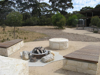
    • Butterfly Campground has a raised viewing platform or patio coming off the Kitchen and Dining Shelter
    • Grassdale Campground has a fire pit, it’s small, and as firewood collection is prohibited in national parks, firewood is supplied. It can only be used outside of the Fire Danger Season, so generally only from May to October. The firepit is adjacent the kitchen and dining shelter. Grassdale Campground is also unique in that a river bisects the campground, with the kitchen and dining shelter and bathroom on one side, and a bridge linking to the campsites on the other.

  6. Food in Campgrounds

    There are no food lockers in the campgrounds, so be sure to stow all your food inside your pack inside your tent. There is so much wildlife on Kangaroo Island you’d be tempting fate to leave food outside, even if in your pack. Birds are a problematic at Hakea Campground (Night 2), not so much because people have been feeding them but simply because they have learnt so quickly where food is kept (inside zippers in packs.) The same birds can be amusing to watch as they admire their reflection in the stainless steel benches in the kitchen shelters. On food lockers, there are shelf units on the vehicle access point, used by tour operators. These tracks can often be found by following the path beyond toilets. The shelving units are just that, they aren’t lockable or otherwise secure, and are for use solely by tour operators. As there are no food lockers, there are also no food drop locations or food swap areas as can be seen on trails elsewhere in Australia. Being only a five day trail, food drops aren’t really necessary anyway.

Maps

The guidebook for the Kangaroo Island Wilderness Trail is very informative about wildlife along the trail. The 1:35 000 topographic map is well detailed.
A detailed 1:35 000 map and guidebook is provided, both need to be collected from the Flinders Chase Visitor Centre when you commence the hike. No doubt this ensures everyone gets a map, but one suspects it also keeps trail information less readily accessible to those who might seek to avoid the booking fee. It also ensures everyone views the safety information, which is presented via a five minute iPad video.

The 1:35 000 map is very detailed (most maps in South Australia have less detail at 1:50 000 scale), and includes an overall map on one side, with detailed inset maps of sections like Flinders Chase Visitor Centre, Cape de Couedic and Kelly Hills Caves. There is also an elevation profile (although really the trail is generally flat) which is nicely detailed showing the vegetation types found along the way.

The 1:35 000 folds to DL size (9.9cm wide by 21cm high), unfolds to A1 size (84cm wide by 59cm high). It weighs 60g.

The guidebook includes useful information about ancient and modern history, and detailed info about birds and wildlife, as well as descriptions of each day’s walk and each night’s campground. View the contents page of the guidebook. If you are travelling in a group we’d recommend carrying one book between the whole group.

The guidebook is A5, 130 pages and weighs 250g.

Audio Tour App

There are thirty guided audio tours to enjoy while you walk using the Kangaroo Island Wilderness Trail Audio Tours app.

Regretabbly we didn't use this app along the way. We'd expect the maps are based on Avenza PDF Maps app which is excellent for use in national parks in South Australia. The official website describes it as:

Each tour is rich in immersive soundscapes and narration making the stories of the trail come to life. For each day, there is a geo-enabled map which offers walkers the ability to track your location even without an internet connection.

Mobile reception on the Kangaroo Island Wilderness Trail is limited, so be sure to download the app and each of the five tours before starting your walk. If you forget, we have outlined where to find some mobile reception on the trail.

When to Walk

The official advice is anytime. From October there are few or no tour groups operating. Summer is often too warm, or at least too unpredictable, although temperatures on Kangaroo Island are generally cooler than the mainland. Generally anything over high 20s is considered uncomfortable for hiking. Walking in summer increases the risk of a Catastrophic Fire Danger being declared, and walkers will be evacuated off the trail if this occurs.

The official website has a section titled Trip preparationSeasons which outlines the benefits of walking in each season.

Suggested Itineraries

The trail is a five day trail, and we've outlined those five days with suggested times in the table below. Below that we have also outlined some short itineraries for those with less time.

There are also pack transfer services being offered (where a tour operator such as Western KI Caravan Park transfers your pack to the next campsite each day), and also options where tour operators or accommodation providers will drop you off each morning and pick you up each afternoon, so you don't have to camp out at the campgrounds.

5 Day hike plan of Kangaroo Island Wilderness Trail

Day Section Name From To Distance Sidetrips Walk Times
Slow Average Fast
Day 1 Rocky River Section Flinders Chase Visitor Centre Cup Gum Campground 12.4km None 5 hours 4 hours 3 hours
Day 2 Maupertuis Section Cup Gum Campground Hakea Campground 14.1km Optional to Admirals Arch (9.8km return, 3-4 hours) - do in the afternoon of Day 2 or morning of Day 3 8 hours 7 hours 4.5 hours
Day 3 Sanderson Section Hakea Campground Banksia Campground 13.0km 2.3km (to Remarkable Rocks, and to Sanderson Beach) 8 hours 6.5 hours 4.5 hours
Day 4 Grassdale Section Banksia Campground Tea Tree Campground 13.3km Optional sidetrip to Hanson Bay Beach (700m return) 8 hours 6.5 hours 4.5 hours
Day 5 Kelly Hill Section Tea Tree Campground Kelly Hill Caves picnic area 7.6km None 3 hours 2.5 hours 2 hours

4 Day hike plan of Kangaroo Island Wilderness Trail

Invariably people may want to walk the trail over 4 days, or if walking fast find some of the days too short.

4-Day Plan #1

This plan combines two days (Days 3 and 4) and is only recommended for faster walkers:

Day Section Name From To Distance Sidetrips Walk Times
Average Fast
Day 1 Rocky River Section Flinders Chase Visitor Centre Cup Gum Campground 12.4km None 4 hours 3 hours
Day 2 Maupertuis Section Cup Gum Campground Hakea Campground 14.1km Optional to Admirals Arch (9.8km return, 3-4 hours) – do in the afternoon of Day 2 or morning of Day 3 7 hours 4.5 hours
Day 3 Sanderson Section + Grassdale Section Hakea Campground Tea Tree Campground (lunch at Banksia Campground) 26.3km 3.0km (to Remarkable Rocks, to Sanderson Beach, and to Hanson Bay Beach) 13 hours 8 hours
Day 4 Kelly Hill Section Tea Tree Campground Kelly Hill Caves picnic area 7.6km None 2.5 hours 2 hours

4-Day Plan #2

This plan uses the average times, but drops the fifth day, and makes the fourth day shorter (end at Hanson Bay) to enable time to drive the 1.5 hours to the ferry. It would be reasonable that people might want to walk over Easter, or add one day to a three day weekend. We highly recommend that if coming over on the ferry the evening prior to walking, that you not try and drive to Flinders Chase near dusk, the wildlife on the road is numerous and very hazardous, especially after passing Vivonne Bay.

Another option is to drop Day 1 from the 5-day plan, and begin your hike at Snake Lagoon Campsite (the car camping area), and begin walking the Snake Lagoon Hike until it meets up with the Kangaroo Island Wilderness Trail. It would add negligible distance, but we'd suggest you start walking early in the morning as the Day 2 Maupertuis Section is long.

Day Section Name From To Distance Sidetrips Walk Times
Slow Average Fast
Day 1 Rocky River Section Flinders Chase Visitor Centre Cup Gum Campground 12.4km None 5 hours 4 hours 3 hours
Day 2 Maupertuis Section Cup Gum Campground Hakea Campground 14.1km Optional to Admirals Arch (9.8km return, 3-4 hours) - do in the afternoon of Day 2 or morning of Day 3 8 hours 7 hours 4.5 hours
Day 3 Sanderson Section Hakea Campground Banksia Campground 13.0km 2.3km (to Remarkable Rocks, and to Sanderson Beach) 8 hours 6.5 hours 4.5 hours
Day 4 Grassdale Section Banksia Campground Hanson Bay 10.7km to Hanson Bay Road, optional 600m down road to beach None 6 hours 5.5 hours 3.5 hours

Packing List

The packing list supplied on the KIWT website is generally quite good. We’d suggest skipping the toilet paper or not bringing much of it (as it is supplied in toilets.) We’d also suggest you don’t need gaitors on this trail. The trail is wide and well formed, so they aren’t necessary. Do use gaitors if your primary concern is to offer some protection from snake bites to the lower legs.

If you're considering whether to wear trainers or runners instead of hiking boots, there are no river crossings to get your feet wet on, and the trail is generally not a muddy one. The river crossings that do exist use bridges or boats.

Wildlife

Watch the seals play and bash in the sun on the Admirals Arch Walk
What wildlife you see will vary depending on the seasons. Kangaroo Island has abundant wildlife, and the Wilderness Trail is no different. You might expect to see:

  • echidnas (but less so in summer)
  • platypus (shy)
  • tammar wallabies
  • kangaroos
  • koalas (less so near the coast)
  • southern brown bandicoots (shy)
  • rosenbergs goannas (a monitor lizard)
  • white bellied sea eagles
  • hooded plovers
  • pied oysterchatchers
  • dolphins
  • long nosed fur seals
  • australian fur seals
  • australian sea lions
  • tiger snake (hopefully just one slithering away eh. There are two varieties of snake on Kangaroo Island, both have the same anti venom treatment)

Beaches & Swimming

Where the trail enters Maupertuis Beach is clearly marked, with an alternate trail along the top of the sand dunes
There are only three beaches on the trail. Day 1 and Day 5 are inland, but Days 2, 3 and 4 are coastal. However the coast is mostly cliff, and whilst there are some small beaches they are generally inaccessible by foot.

Officially they advise against swimming, but we can offer the following advice about the three beaches:

  1. Maupertuis Beach

    You will walk 1.5 km along this beach on Day 2. Watch out for Hooded Plovers which make their nests in the sand above the high tide mark and the dunes. The beach is remote and can only be accessed by hikers. The best place to swim on this beach is towards the end of the beach, around the sandy headland. Here there is a large lagoon, formed by a shallow reef further out to sea.

  2. The remote Sanderson Beach, on the Kangaroo Island Wilderness Trail. The beach is only accessible by walkers on the trail.
    Sanderson Beach

    The beach here is on a spur trail near the finish campground on Day 3. The beach can make good swimming, but as always be very wary of waves and rips (stay close to shore.) The beach is remote and can only be accessed by hikers.

  3. The walking trail comes out onto Hanson Bay
    Hanson Bay Beach

    This beach is a public beach accessible by road, and is on a short spur trail on Day 4. It’s a beautiful calm beach, suitable for swimming for most swimmers.

Bushfires

Bushfires are a real concern in south-east Australia, including Kangaroo Island. The Fire Danger Season begins in October or November, and continues through to March. During this time campfires are not permitted in any national parks.

Each day during the Fire Danger Season a Fire Danger Warning is issued. There are six ratings:

  • Low-moderate
  • High
  • Very high
  • Severe
  • Extreme
  • Catastrophic

If a Catastrophic warning is declared for the Kangaroo Island Fire Ban District for the following day, the national park will be closed and the trail evacuated. Rangers or tour operators will make arrangements to get people out of campgrounds and out of the park. This would be unfortunate but with the very real danger to life, largely unavoidable. Besides, it would make very hot walking anyway.

Fire warnings and weather forecasts are posted by a ranger daily on the noticeboard in each campground.

Marked on the map are Last Resort Refuges (marked by red triangles) and Assembly Areas (marked by yellow triangles). The Last Resort Refuges are just as the name suggests, usually an open area offering minimal protection, and there are just two on the Kangaroo Island Wilderness Trail.

Assembly Areas are located at:

  1. each of the four campgrounds on the trail
  2. Admirals Arch carpark (Day 2 or 3)
  3. Remarkable Rocks carpark (Day 2 or 3)
  4. Kelly Hills Caves picnic area (Day 5)

Last Resort Refuges are located at:

  1. At Admirals Arch, on the platform under the arch (Day 2 or 3)
  2. At Grassdale, in the middle of the open grassed area near Edwards Cottage (Day 4 or 5)

Other logical places are the three beaches on the trail, at:

  1. Maupertuis Beach (Day 2)
  2. Sanderson Beach (Day 3)
  3. Hanson Bay Beach (day 4)

Never seek refuge in a rainwater tank or pond. Avoid seeking refuge in a pool or river.

Drinking Water

There is filtered tap water available in the kitchen area. They recommend to treat all water
The supply of drinking water on this trail is considered very reliable, unlike some other areas of South Australia. The campgrounds have been well designed to capture a lot of rainfall, with 3 water tanks off the main kitchen and dining shelter, 2 off of the bathroom shelter, and extra storage tanks near the road access point. We would anticipate that should water run low, that water tankers would refill water (hence the connected water tank at the road access point.)

You can obtain water in the kitchen and dining shelter.  The sink here has two taps – one with filtered water which has to be hand pumped (about 15-20 pumps per litre) and one normal tap. The water flows slows, no doubt as a control measure to reduce water wastage. If filling water bottles, the single tap on one of the three large water tanks beside the shelter flows much quicker. None of the water is treated, and they encourage you to treat it yourself. However the structures are new and well designed to reduce tank water contamination. For instance, each roof is fitted with a First Flush Diverter. This device works by allowing the first lot of water from rain to clean the roof of debris and to capture that debris in an overflow device. Subsequent water, which is uncontaminated, then flows into the tank. This ensures water flowing into the tank only does so when there is a good volume of rainfall, rather than during passing showers.

Mobile Reception

Mobile phone reception is generally limited to Telstra. We didn’t check for reception thoroughly along the trail, but we can provide information about each campground:

  • Flinders Chase Visitor Centre: excellent reception, but only nearby to the building
  • Night 1 (Cup Gum Campground): some limited reception, maybe no data service though
  • Night 2 (Hakea Campground), none
  • Night 3 (Banksia Campground): not sure
  • Night 4 (Tea Tree Campground): 1 or 2 bars with data
  • Kelly Hill Caves (end of the trail): good reception

Ending the Hike

The Kangaroo Island Wilderness Trail ends at the visitor centre and picnic area at Kelly Hill Caves.

Trail Transfers

When booking the trail through the website, you can also purchase a shuttle service for an additional $25. The bus will be at Kelly Hill Caves at your day of arrival at 2:45pm.

Alternatives to provide you with more timing flexibility include:

  • using multiple cars between friends (a car shuffle: leave one car at Kelly Hill Caves and one at Flinders Chase Visitor Centre).
  • Exploring options with other tour operators, for instance the Western KI Caravan Park offers guests who book cabins or camp at their caravan park transfers to and from the start and end of the trail. The caravan park is situated midway between the start and end points, so is ideally placed for this.
  • One person from your group could ride a bicycle which you have stored at Kelly Hill Caves. The ride is 17km, and there are several hills (you are after all starting in Kelly Hills).

In the Suggested Itineraries section we review shorter ways to walk the trail.

Showers and Laundry

After you complete your trek you are welcome to have a shower at the Rocky River Campground near the Flinders Chase Visitor Centre. Actually anyone can have a shower there, for people not camping there it is $4 per person, but as a KIWT guest the shower is complimentary.

The Western KI Caravan Park also offers complimentary showers to hikers finishing the trail. The caravan park is 10km west of Kelly Hill Caves, just 7km before reaching the Flinders Chase Visitor Centre.

Groceries are available nearby from the Western KI Caravan Park and Vivonne Bay General Store (closed at Dec 2016 due to fire but expected to reopen early 2017).

Details of each Trail Section

Details about each day's walk appears in Walking SA's Find a Place to Walk directory listing for the Kangaroo Island Wilderness Trail.

We've listed each of the 5 sections on a separate entry, or read the summary page.

Monday, May 20, 2013

Mt Woodroffe, #7 of the State 8

Is it OCD? That sees a list of the eight highest peaks in Australia's states and territories and then wants to tick them all off? Maybe. This one, Mt Woodroffe - South Australia's highest peak - was my number seven, of eight, the so-called State 8, or Aussie 8. Apparently I'm not alone in my affliction, there were 28 other people booked onto this tour.
SUMMARY - Mt Woodroffe climb/hike
Duration1 day hike (3 day trip)
Start/endNgarutjara (3 day trip to/from Uluru)
FridayDrive from Yulara, Uluru, to Ngarutjara camp (base of mountain)
SaturdayHike up Mt Woodroofe (Ngarutjaranya) 1435m
SundayDrive from Ngarutjara camp (base of mountain) back to Yulara, Uluru
AreaAPY Lands (permit required)
BookingsDiverse Travel Australia, SEIT Outback Australia
Topographic Maps1:250 000 Mt Woodroffe SG52-12: printed map, on-demand 1:100 000 print, free download (official map)

The only way to access Mt Woodroffe, in the remote APY Lands in northern SA, was via a tour group. Once a year they run a trip in, and it's the only one with permission from the Traditional Aboriginal Owners to do so. It's also rare for them to give anyone else permission, so the tour is the most practical way to do it. It makes Mt Woodroffe the most difficult of the State 8 to organise.

With the permission in mind, at our camp on the first night near the foot of the mountain, we were visited by Lee, one of the Custodians. As can happen in these situations, we took him all a bit too seriously, almost missing his first joke and his fine sense of humour.

When he first sat by the fire, he took his shoe off to warm his foot, complaining about the severe pain in his foot that a heel spur was giving him. Of course we doubted - I can hear your mocking cries now - that he would make it to the top of Mt Woodroffe. We were equipped with all our expensive hiking gear, when he looked more like he had come from fixing a car (he had, as it turned out). Of course, how wrong we were, it was Lee who led the charge up the first steep waterfall rockface. Few followed up the waterfall though, preferring to pick an easier route over a gung-ho approach. There was no doubt that Lee got into as much mischief now as he did when he was a ten year old boy.

Later Lee's father, aged 82, arrived. It quickly became apparent that he would talk in exchange of cups of tea, and if the tea disappeared so would he. He talked with a hint of humour in his slow words. He'd only been learning English in the last 10 years, evidently taught by the many school girls that came out here on school trips (SEIT tours core business is ten-day school Aboriginal cultural camps, this being one the campsites they use for that). I'm not sure how much that skewed his vocabulary, but in exchange he would teach them his language.


On our first day, after arriving at camp, we were taught how to not use the supplied swag, and a discussion ensued about the wisdom of camping in the creek bed, with it soft sand and shade. Normally, of course, this is a poor decision - to camp in a creekbed - but when you can see the headwaters, just a mere 7km away up the mountain, it's pretty safe to camp, even in a wide creek. I've done it before when the headwaters can be seen. If it rains, and especially if it rains a lot, then it's time to move. Pretty hard to miss rain in a swag.

We drove over to the foot of the mountain, to assess routes to hike and climb up the following day. Being a rogainer, I was already formulating a few options into plans, and on the drive closer was able to clarify some of them. At the foot, with most of the mountain obscured behind the immediate base, advice was given as to the easiest routes, and as to where the harshest spinifex lay.

Before dawn the following day, we drove back to the base and at first light set out. It was a case of each to their own, or better still, in small groups. A few set out directly from the cars with a short but sweet route, a straight up the mountain. It was a route plotted through the harshest spinifex, but nonetheless a sound route. Most others followed Lee to the waterfall rockface, before quickly dispersing by a variety of routes. For a while there it looked like we would find about 29 different routes up the mountain. I took a gentle route around the waterfall, taking my plotted course up to the ridge in the east, before hiking up the long spur to the summit. It was the easier route, relatively free of spinifex, and easy to navigate. Although I got to the top first, even having taken the longest route, I had hiked alone, and no doubt that allowed for some speed. It was just seven minutes later that the next group arrived, having taken the most direct route up from the cars.

For all my efficiency and speed in getting to the top quickly and with minimal spinifex injuries, I must have banged my head on the way down - maybe I should wear a safety helmet on such climbs - for I momentarily lost my mind. I decided against taking the three additional people now hiking with me along the long distance ridge, and decided on a shortcut down. Ricky, perhaps sensibly, decided to hike on along the ridge to the western end and it's unnamed summit. It wasn't long down our shortcut that it became obvious - this was no shortcut, and indeed, it took us longer to complete then the distant route. Thankfully I brought those three companions to share the misery of my foolishness. Ricky, having completed his second peak climb, caught up with us near the base. So much for our shortcut. Encouragingly, it seemed that everyone was slower on the trip down, compared to their trip up.

The view from the top took in distant Uluru and Kata Tjuta, some 130km away across the NT border. The Musgrave Ranges spread out to the east and west, a mess of scraggly mountains. Many South Australians don't know what lies up here, thinking that St Mary Peak in the Flinders Ranges, on the Wilpena Pound rim, is the highest peak in South Australia. It's not. Here in the Musgrave Ranges lie 21 mountains over 1,000 metres, and the top seven mountains of the State. St Mary Peak comes in as the 8th highest. Mt Woodroffe rises 680 metres above the surrounding plains.

An old stone surveyor's cairn marks the top of the mountain. A famous photo, taken in 1933, with three Pitjantjatjara guides, shows how the cairn originally appeared. The mountain was named after George Woodroffe Goyder, the 1857 South Australian Surveyor General highly regarded - at least now anyway - for his work in establishing what became known as Goyders Line, the line across the state that marks arable farming land from that which is not sustainable farming land. He was mocked at the time, but hey, at least there's the odd thing around the state named in his honour.

My skills in the exploration of the stone cairn fell well short of my skills displayed in getting up the mountain, and it was someone else who found the logbook in a rusted old can buried deep in the stone cairn. The word 'logbook' is a somewhat generous description, it was almost entirely a collection of rotten indecipherable paper fragments, with the odd modern addition of single pieces of paper. Why some people feel the need to describe the 'marvelous' or 'spectacular view' they saw is beyond me, it's really quite self evident to others who have managed to get there to read the logbook. Anyone with the misfortune of climbing in poor weather, which really is misfortune in Central Australia's stable weather, would hardly find enlightenment with the description of the view in the few moments they spent huddled on the leeward side of the stone cairn before heading back down.

With 29 people on our tour, every one of them made it to the top of Mt Woodroffe that day. Whilst it's cliched to say "there's one in every crowd", it was nonetheless true. If there is one thing more fun than 29 people on a tour, it's this: 29 people offering advice to the one person who is scruffing around in the red dust under the vehicle with a car jack replacing a blown tyre. That wasn't quite true, we had two vans and a ute for the tour, so whilst there were plenty offering advice, it wasn't quite as bad as 29 people. It was a big tour group, I had been warned when I booked that if the tour didn't reach the minimum of four people, it would be cancelled. Last year it was cancelled, with just two bookings.

So in my State 8 pursuit I've been all around the country and found many hiking places to return to. My first peak, Mt Ossa, in Tasmania was mostly accidental, a side trip on the Overland Track. I almost gave up climbing it too, if it hadn't been for Tim's enthusiasm. Now five years later, only one remains. A crazy plan is in place to complete it - Queensland's Bartle Frere. We shall see my friend, we shall see.


View photo album in Google Plus (9 photos).

More photos to come


View in full screen format
Download GPX file of the Mt Woodroffe summit climb hike - for use as a navigational aid in a GPS unit
Download KML file of the Mt Woodroffe summit climb hike - view in Google Earth

My State 8 (Aussie 8)

The highest peak in each Australian state and territory:
  1. Mt Kosciuszko, New South Wales (NSW), 2228m, March 2012
  2. Mt Bogong, Victoria (VIC), 1985m, March 2012
  3. Bimberi Peak, Australian Capital Territory (ACT), 1913m, March 2012
  4. Bartle Frere, Queensland (QLD), 1622m, NOT YET DONE, June 2013?
  5. Mt Ossa, Tasmania (TAS), 1617m, December 2008
  6. Mt Zeil, Northern Territory (NT), 1531m, July 2012 (first attempt August 2011)
  7. Mt Woodroffe, South Australia (SA), 1435m, May 2013
  8. Mt Meharry, Western Australia (WA), 1252m, June 2010

Tuesday, January 8, 2013

Caught! A hike turns into prison island

The Tasman Peninsula in Tasmania is isolated - it is essentially a series of islands joined to the mainland by two narrow isthmuses. With those natural barriers you can see why it was chosen as the site for the notorious Port Arthur prison for re-offending convicts – those convicts who committed crimes whilst serving sentences in other Australian convict prisons. Despite the prison closing in 1877, over the past few days the peninsula has again became a prison island for residents and travelers alike. Bushfires burning on the mainland and the upper peninsula isolated those beyond the fires. But like the odd convict, I made a successful escape on a fishing barge.

Having completed a hike through some of the Western Arthurs in South West Tasmania, I bid my farewell to Kate, Tim and lil' Gracie, who we established in the last couple of days was making a sound that was quite probably my name. I bussed it out to Eaglehawk Neck, on the Tasman Peninsula, for four marvelous days of easy hiking, camping and novel reading along the Tasman Coastal Trail, near Port Arthur.

Of course I didn't know that the bus trip out was a tour of the soon to be devastated and somewhat grim bushfire zone. Glad I looked out the window at the quaint little towns and the glimpses of houses settled in pretty forests.

From Eaglehawk Neck, having encouraged some fellow backpackers that no-one would care if they camped freely on the beach, after all I was planning something similar, I hiked along the beach towards Doo Town. I had no appreciation for that town name yet, every bloody house was named "Doo-Little" or "Doo-Relax" or something else equally corny. Later I learned the town name came from the first shacks, named using that convention, rather than the shack names from the town name. Now that's much more original.

I hiked along a short track, checking out the creations the sea had made in the limestone cliffs - blowholes, caves and canals. From Waterfall Bay I planned to set out on the Tasman Coastal Trail, a short distance to a pleasantly named Camp Falls. Time was getting on, it was well past seven, and even with the 9pm sunset I was nervous, what if there was no water there, or, as it didn't appear on all official maps, no campsite in the forest? Staring blankly at my map while standing at the trailhead, readying myself to take that first nervous step along the trail, two people stumbled out of the bush, looking for the said campsite. Clueless in the where-am-I-map-reading-game, they had clearly walked past some picturesque waterfalls, perhaps looking for something more like a five star campsite than simply a clearing beside a waterfall. I didn't want to seem rude by telling them their map reading skills were evidently craptacular, so we wandered around looking for a suitable place to lay the tents. They were ever optimistic, "the campsite might me down here", yes surely, a name like Camp Falls wouldn't be at all derived from its proximity to said falls. I settled on a fire track junction, as good a clearing as any in the sunset, and they continued on looking for the Lost Gold of the Mayans, amongst other things.

The following morning, when I came upon Camp Falls, I was of course devastated, it was gorgeous. A fantastic secluded campsite in the forest, easily room for half a dozen tents, no mud, and not one but two sets of Norsca shampoo style waterfalls, the other aptly named Shower Falls. Which I thought, of course (as I am wont to do) was a bloody brilliant idea.

I continued on my merry way, soon realising my own map reading skills hadn't been too brilliant as I made a 500 metre ascent of a mountain in the way of my planned campsite. By lunchtime after another refreshing swim, this time in the pleasant waters of Bivouac Bay, I settled down for an afternoon of reading at the campsite. A 500-page book was just perfect. Yes yes I hear you, but on a Kindle, too heavy to carry all the books I intended to read on this hiking trip.

The following day I returned to Camp Falls, I couldn't possibly pass up camping here. Sitting quietly on a nearby headland overlooking the ocean, I contemplated how marvelously I had organised this particular trip. Great hiking, great campsites, great water and great books. Perfect. Then the ocean turned a distinct orange hue, and my circumstances changed quite dramatically.


Behind me a huge smoke cloud was growing, and approaching at some speed. The sky turned red and the colour grew eerie. No wonder the Mayans turned to sacrifice when midday sunlight was eclipsed, this was surreal.


View map in full screen format

Download GPS file of Tasman Coastal Trail

View a 2008 blog post about the southern end of the Tasman Coastal Trail, from nearby Fortescue Bay out to Cape Huay and Cape Pillar.

Just as I was contemplating the leap off the coastal cliffs to the treacherous ocean below, so close and enormous did the fire now seem, I found some mobile phone reception. Lap it up Jeremy, the mobile network was soon to be lost in the fires. I established that the fire was some 30km away, and I was merely the victim of the smoke. Surely I could camp here still. I wasn't too far from a town. But the decision didn't rest easy with me. I could barely sit down. No, this was stupid. If the smoke was here, the fire, even 30km away, was on its way. Just before packing up my unslept-in tent, I checked the updates on the internet again. Oh shit. Things had gotten decidedly worse. The fire had leapt two bays, and was now the other side of the ridge just three or four kilometres away. Not only had I now received an emergency evacuation sms, but the nearby Doo Town was to be "impacted by fire within 10 minutes".

I now proceeded to set a new time record in packing my pack, and another in the fastest exit off a trail ever. It was hot, and the smoke had me scavenging around in my first aid kit for my ventolin puffer. An hour later I made it into the relative safety of Doo Town. Mothers were hurriedly filling their cars with possessions and children, whilst husbands cracked another beer, turned on the hose and peered grimly into the distance.

A police car pulled me up beside me, gave me a good dose "what the fuck are you doing", well please, travelers on foot get stuck in disasters too. I explained my plan was to get to the boat ramp and ocean, it seemed infinitely safer than the campsite in the forest I was at, and did they have a better plan for me. Yes they did, get to the fire refuge at Nubeena. Not being a local, I didn't know where that was, but sure it wasn't within walking distance, the boat ramp I proceeded to, keen on picking up a lift from a local to the fire refuge.


The locals thought little of the police evacuation idea, preferring to watch their houses burn from the comfort and relative safety of the boat ramp, the ocean and their waiting boats. Within minutes I had made friends and found myself a cold beer - a Cascade no less, none of that VB or XXXX canned shit down here - and a sausage fresh off the bbq, and settled down to watch the unfolding scene.

The witching hour of bushfires almost over, as the 3 to 6pm time is when bushfires go feral, as this one had, things calmed down a bit. Ash was falling from the sky, and I pondered whether I should find a young virgin to have sex with immediately, as things seemed to be shaping up much like a certain town once known as Pompei. I could see up the hill that the police were going from door-to-door evacuating people.


As the sun set, gorgeously of course because of all the smoke and ash in the air, the locals grew weary of this "emergency" thing. The fire had progressed no further, it hadn't made the ridge yet, god knows how it wasn't over it yet. Distressed by the idea of sleeping in their boats, on the beach or in the cars, the townsfolk simply gave up and returned home. There was no power on at home anyway, goodness knows why a bed in a stinking hot house seemed attractive over the beach. Sleeping on the beach, much by myself, wasn't too easy. At midnight I could see the flames on the ridge across the bay, the nearer ridge wasn't yet showing the same red glow but it seemed likely it soon would be. I could see the police going around from house-to-house again (de-ja-vu?), evacuating people again. Although I knew the tide times (how?), at 3am the beach sleeping decision showed itself to be a remarkably short sighted option. Scrambling, such was the incoming tide, back to the carpark, I found it now full of people sleeping in cars. Aah such comfort. Fellow people, we would make it through this.

Dawn broke at 5am, and predictably, the townsfolk were again weary of this evacuation, and they trotted back to their homes. I was almost all alone again on the jetty, the fire didn't seem to have progressed, the wind had changed direction and the sky above was now clear and sunny.

Bored by myself on the empty jetty, I trundled down the beach to Eaglehawk Neck. The nearby mobile phone tower had obviously now succumbed to the fire, and the police weren't visiting anymore with new information. The road was blockaded at Eaglehawk Neck, and it was the official evacuation place over Doo Town.

So now I spent my day sat in the shade of a pleasant tree on green grass, watching with much bemusement as car after car drove up to the roadblock trying to get down the road off the peninsula. I met and chatted to a few locals who had lost their properties. There was no electricity, running water (what's with all the pumped water), no working fixed phones and a pretty dodgy stand on one-leg dance to do to get a somewhat sometimes bar of mobile service, if one could find the single sweet spot down beside the lake that got the magical if not damn illusive phone reception. But I was well placed, the police were on hand with lots of misinformation. Every once in a while they would tell some more which would be chinese whispered into the waiting crowd. Often when one finds oneself in an unfolding disaster reliable news information can be quite hard to get, as was the case here. What we later did read in official news didn’t necessarily matched up with what we had seen first-hand. By Tuesday afternoon the Tasmanian government acknowledged that their biggest learning so far related to the single biggest frustration of people being rescued from the peninsula - a lack of information (or indeed, any information). Hard to imagine, but reliance on a working telecommunications system might be shortsighted (even if it kept working, how would you charge your phone after a 72 hour power failure?). Maybe we all need to go back to using AM radios, that is what one of the main parts of the ABC's (Australian Broadcasting Corporation) charter - to reliably broadcast information throughout Australia in emergencies.

We settled down to another smoky night, to the sound of the occasional piece of heavy machinery making a dash from one fire front to another.

The following morning it was evident that the attitude amongst the gathered people, few that they were, was turning a corner. Angry was the name. The lack of information from the police wasn't helping, and with no more phone service the rumours were doing their work. It seemed people would soon be exchanging blows as they rated other people's creative news interpretations.

It was increasingly evident that the road off the peninsula would not re-open for another couple of days, so I hitched a ride further down the peninsula with Mathew and Kate, and Mathew's two kids. They had spent an ugly night trying to sleep in their van without any blankets, whilst I'd spent the night sleeping on my blow-up hiking mattress with my sleeping bag in the ash rain. We drove over to Nubeena, the official safe place fire refuge. There were 2,000 people there, and sure to be a good supply of food, and possibly even power and phone service.

Arriving just in time for a community briefing, it was clear things had got pretty grim up there in the hills on the road above Eaglehawk Neck. News here flowed much more freely, and with much more of an official and credible tone. Crews were doing a sweep from property to property, evidently looking for what no-one wanted to find. The road back was clear, well clearish, but it was slow going. The main issue with the road now was twofold, one they were hastily re-erecting power poles so as to restore power to the peninsula. Secondly, and we had got a sense of this back at Eaglehawk Neck that morning, things had turned, it was now a crime scene up there. They didn't want people poking around unnecessarily, messing with things and risking finding that awful find.


Freshened with some fresh food, a quick charge of the mobile phone, mobile reception and a quick trip to the local powerless chemist for an emergency supply of medication, my stay in Nubeena turned out to be quite brief. It seems I really did luck it up by hitching a ride with these guys. Mathew set about contacting a friend of an uncle's friend he once worked with, or some such tenuous relationship, with a fisherman with a do-anything go-anywhere barge who worked locally. It seemed an incredible and somewhat unlikely plan.

But he wasn't the only one working on him, a close friend of this fisherman's wife was also making contact. A plan had been hatched. I suspect the close friend of the wife was the clincher in this deal. With Mathew's phone flat again (there was lots of competition at the charging station), the close friend started the exploration of the 2,000 people in search of a family she had never met: an average height guy, kinda skinny, with some awesome tatts, and a wife, of average height and brown hair, two kids and a white van kinda thing. Shouldn't be too hard hey? They entered the main compound, and there beside the gate on the street we were, having selected a spot beneath some trees that looked set to provide reliable shade all day long. "Are you Mathew and Kate?" I don't think she could believe her luck at finding them so easily. The fishing mate had left Hobart already with the fishing barge and would be arriving in two hours.

We went down the local wharf, where the local guy who had generously taken it upon himself to assume control of the jetty informed us that calm as the sea looked, the kids were at great risk of being swept off the jetty by a freak wave. Such was this quiet bay.

A larger ferry was coming in with more food supplies, and the jetty man was adamant there was no way our barge was getting to get in its way. Fair call, we couldn't dispute that. Having established we were there for a reason, unlikely as it seemed, we took to joining the parcel line helping unload a few fishing boats with valuable supplies of water and baby goods, and then loading them into waiting utes.

With fresh news of the barge's imminent arrival, the jetty man cleared a small spot beside the wharf. As the barge made its way in, one thing was clear, it was much bigger than any other boat here, and it wasn't going to fit into that little gap. Size counts on the sea, and the other skippers soon moved their boats out of harm’s way. Thankfully there wasn't much being unloaded by now, so that settled our consciences a little.

The grumpy jetty man appeared to be impressed by the barge and its skipper's plan, and cheered up lending a hand getting the three cars on board, which was no mean feat in itself.

A gathering crowd, hearing rumours of an incoming goods ferry that might "take a couple of people" back to Hobart, watched with what could only have been great mirth as the fishing barge docked, and set about loading three vehicles using a crane and precarious system of straddling the cars across the jetty and barge.

We watched on as Mathew did what can only be described as the most impressive parallel parking attempt in history, as he inched his van backwards and forwards in a thirty-point shuffle between the barge superstructure and the perilous edge of the barge.

A handful of santa sacks from the hospital appeared on the wharf, and it only seemed right to grab them for the journey back to Hobart. Assured they contained "no sharps, I think, some sheets with bodily fluid but no shit and stuff", um, interesting understanding of the phrase "bodily fluid", we lightly manhandled the leaking bags onto the barge as well. And we were off, incredible as it seemed, and possibly just as incredible to the gathering crowd.

If you had told me Sunday morning that I would be off the isolated peninsula that very day, I would never have believed you. I truly thought I would be stuck to at least mid-week, long overstaying my holiday and missing work.

Two hours later we were back on the mainland. I can’t think what the fuel for the barge would have cost. Somehow a slab of beer seemed somewhat inadequate as a thank you gift. Mathew and Kate had given me a pretty awesome ride hey, they even dropped me off at the caravan park near the airport. I had to pick up my bag I had held at the hostel I was going to stay at in the city, I had missed my booking of course and they were full up. Later, at the caravan park, the hostel called me enquiring as to when, and if, I would be turning up tonight. They'd mixed up my booking. Oh well, in the morning the airport was just a stroll away. With the promo code #bushfire I had a free flight home with Qantas - top work!

Conditions have worsened in the days since, with the safe areas and remaining people at Doo Town and Eaglehawk Neck told to evacuate to Nubeena, as the fires flared up in strong winds and further roads were closed.

A part of me missed the opportunity of the bus trip off the peninsula. If I had gone that way I would have seen some of the destruction first hand, but that's the macabre guilty sticky-beak side of me hey.

A big thanks for all those of you who followed the unfolding drama on Facebook. I couldn't always, or often, see what you were saying, such was the limited reception, but it was encouraging so many people were concerned about my safety. Just another hiking adventure really. Floods, bushfires, helicopter rescues, transformed deserts, it all happens.

Even after swapping some details, I couldn't find Kate on Facebook. If anyone knows a Tasmanian woman of average height with brown hair, and a partner of average height, kinda skinny and with some awesome tatts, put me in touch. Ha ha. Appalling description. If anyone knows a woman with a good sense of humour, and a friendly partner running a carpet cleaning business with the occasional tatt, both into Kung Fu, who live in Snug south of Hobart, I think we might have them. I've got more details, but it starts to sound weird to leave it here.

View photo album in Google Plus (14 photos).