Showing posts with label Adelaide Bushwalkers (ABW). Show all posts

Monday, August 6, 2012

Nakun Kungun Trail, Coorong

Looking. Listening. These are the catchcry words of the Nakun Kungun Trail, a 27km hiking trail through the Coorong.
SUMMARY - Nakun Kungun Trail, Coorong (sometimes spelt Nukan Kungun) - a two day weekend hike with the Adelaide Bushwalkers (ABW)
TrailheadsSalt Creek in the north, 42 Mile Crossing picnic area/campsite in the south
Friday night campsiteCampsites at the northern end of Loop Road, 1km from Salt Creek
SaturdayCampsite (near northern end of Loop Road) to free-camp near the southern end of Loop Road - 13km/5hrs
SundayLoop Road to 42 Mile Crossing picnic area, with sidetrip further out to Coorong beach (9.5km/2.5hrs + 3.2km)
National ParkCoorong National Park
Nearest townSalt Creek, consisting of petrol station
CampsitesOfficial campsite near Salt Creek (toilet in picnic area) and 42 Mile Crossing (toilets in picnic area). Free camping permitted along trail.

Saturday morning our walk leader, Kate, spotted a Mallee Fowl, or possibly, as she conceded, “a wild chicken”. It seemed most likely to be the Mallee Fowl, endemic to this area, there were plenty of interpretive signs about them. Tellingly perhaps, no-one else saw the encounter. Kate was, as a birdwatching expert, her own downfall. On the drive home she spotted a similar creature scurrying near the roadside, and upon consulting her bird book deemed it to be hen of some sort (she did know the sort, I just don’t recall it).

Invitations to explore one of the many large wombat holes to find their happy inhabitants were quietly declined. No matter, eventually we came across a shy wombat, who had curiously made its burrow under some timber decking at an historic site. It would seem not many people passed this way, despite this particular area being signposted from the bitumen road.

Later we spotted an echidna, who shyly crawled under a bush and curled into a ball.

We saw many birds, including hooded red robins playing on fences, but not being on the shore, few pelicans.

So our looking and listening did pay off.

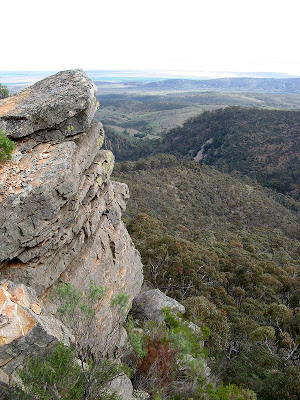
What we didn’t see was much of the Coorong. Although the trail follows the Coorong it does so at a quiet distance, only at its very southern end does it venture near the sand dunes or the shore line. There it also makes its passage over the water via the 42 Mile Crossing.

On Saturday, after setting up our campsite near the southern end of Loop Road, we set off bush bashing to find the illusive Coorong shore. In windy conditions we found the body of water choppy, and far too wide to attempt to cross.

On Sunday, beyond the picnic area at 42 Mile Crossing we battled the wind and brief driving rain to cross the seemingly endless dunes to reach the coast. The waves were being lashed by the wind and the strong waves were eroding the beach. It was, as this beach often is, spectacular.

We were disappointed that following the trail meant we infrequently visited or caught glimpses of the Coorong and its distant sand dunes, but the looking and listening was rewarded with some great wildlife sightings. For the most part the trail passes between the main bitumen highway and the dirt Loop Road, with the Coroong water and iconic Younghusband Peninsula further west. Only infrequently did we hear or catch glimpses of the roads. The trail passes beside many shallow lakes, which are separate from the main Coorong water body. During drier times these would be dry salt pans.

The trail is reasonably well maintained, and is signposted, but isn’t well travelled, so occasionally we did loose sight of the trail. Doing so wasn’t unpleasant, the areas were often covered with fine green grass. Often when we misplaced the trail we followed the tyre prints from a recent ATV vehicle, presumably from a maintenance ranger. Without that I think we would have spent much more time wandering the scrub.

View photos on Google+.


View in full screen format
Download GPX file of the Nakun Kungun Trail (corrected) - for use as a navigational aid in a GPS unit
Download KML file of the Nakun Kungun Trail (corrected) - view in Google Earth

Monday, June 11, 2012

Dibber Dobber Dabber

Well no-one dibber dobbed, but we did finish off our three day trek hiking up Mt Dib and Mt Dab, and um, Dob, and a little of Deb. Leaving our campsite, we started our summit attempt on Mt Dab, until it became clear it was Deb, or at least not Dib or Dab. Progressing across the saddle to Mt Dab, then onto Mt Dib, which was most certainly Mt Dab... oops. Every time we reached a summmit we saw another, readjusting our minds to exactly which ones were Mt Dib and Mt Dab.

SUMMARY - Aroona Valley to Blinman Pools, return via Wild Dog Creek
Start Aroona Valley Campsite
End Aroona Valley Campsite
First Night The Cascades
Second Night Pigeon Bore
Time 3 days
Distance 57km
It wasn't the only navigational challenge we experienced, but our uncertainty added minimal distance to our three day trek. Navigation across the landscape is an element that makes a trek so good, opening up the possibilities of where we could go. Camping at The Cascades, a cross-country hike to Blinman Pools, hiking through the Wild Dog Creek canyon and summiting Mt Dib and Dab were the highlights of the weekend.


When we reached the Cascades mid-afternoon on Saturday, it was clear, even without a vote, that no-one was keen to continue on that afternoon to Blinman Pools. The Cascades were beautiful, it was clear, flowing water, the first water we had seen in a creek. Even more amazing, just a few hundred metres upstream, the creek was dry. The source was a spring - the water was warm, and there was plenty of it. We enjoyed our early camp with a camp fire and salmon and soft cheese crackers. Following the previous night's late arrival by bus, and our day's 20km hike, we retired early, to our already icy tents.

Sunday morning was cold, very cold, minus three. In the cold we set off with our daypacks, armed with Kate's 1:33 333 map and landscape familiarity from a recent rogaine, crossing the countryside to Blinman Pools. There was plenty of water in the pools, a stark contrast to what I saw when I was last here in the drought during 2007 - no horizon pool back then. The large, deep pool was irrestible, Ros and I jumped in for a swim - maybe the wrong verb, it was very cold, an instant brain freeze, so we scrambled out pretty quick.

We returned to our now dry tents, grabbing our packs and trying our hand at some creek navigation, always difficult in the Flinders Ranges. We lunched in a creek bed, each of us with varying degrees of lunch envy, before walking through Wild Dog Creek and onto the Heysen Trail, wandering south to Pigeon Bore. We made it in late, just after sunset, just managing to set up our tents before seeking out our torches.

We joined two other ABW groups around the fire, sharing our last rations of alcohol and chocolate.

Early on Monday, five dedicated walkers of the 12 strong group tackled Dib and Dab. We were rewarded with spectacular views of the Heysen Range, Wilpena Pound, and the landscape east all the way to Patawarta, all soaked in the early morning sun.

Maybe some more photos to come soon...


View in full screen format

Download GPX file - for use as a navigational aid in a GPS unit

Download KML file - view in Google Earth

Stats

Aroona Valley to Blinman Pools and return via Wild Dog Creek
Saturday Sunday Sunday Monday
09/06/2012 10/06/2012 10/06/2012 11/06/2012
Aroona Valley campsite to the Cascades The Cascades to Blinman Pools and return The Cascades to Pigeon Bore Pigeon Bore to Mt Dib and Mt Dab, return to Pigeon Bore then to Aroona Valley campsite
Distance 19.9km 8.33km 18.93km (total 27.26km Sun) 9.51km
Start Time 8.43am 8.08am 11.33am 10.04am
End Time 2.37pm 10.45am 5.33pm 11.05am
Moving Duration 4h04m 2h0m 4h19m 2h31m
Stationary Duration 1h34m 1h01m 2h09m 36m
Moving Average 4.9km/h 4.4km/h 3.8km/h
Overall Average 3.4km/h 3.1km/h 3.1km/h
Oodometer 19.9km 28.23km 47.2km 56.9km

TRACK NOTES - Aroona Valley to Blinman Pools and return via Wild Dog Creek
Download larger version of track notes

Sunday, June 3, 2012

Mt Crawford Forest

A wander through Mt Crawford Forest with the under 40s group from Adelaide Bushwalkers. Hot potatoes on the campfire and warm mushie bananas with infused chocolate, Kate set a high benchmark for our first hike.

SUMMARY - Mt Crawford

with ABW u40s group
Start Hale Conservation Park
End Lucky Hit Farm
Time 2 days
Distance 27km
Oh, it's true, she cheated with the potatoes and bananas. No-one, well no sane person, would carry 12 potatoes and 12 bananas in their pack into the campsite of the first night for our two day hike. She smuggled them there with her car, caching them away behind a tree. We all approved of her cunning though, smart move.


There were 12 in our group, after the usual formalities of the car shuffle, we hiked our way through the southern end of Hale Conservation Park, somewhere I have never quite seen due to a too-deep river crossing last time I was there. A bit of scrub, a deep valley, a snack and rest on a ridgetop spur looking over the rolling farmland and forest - all very nice. Some of Warren Conservation Park - great scrub and views - then some country laneways, and eerie forest (forest is always good eerie, as the wind gently blows through the pine needles.) It's true, some of the intruders amongst us complained when bits of trail were overgrown, that every plant in Australia was sharp, overly pointy and liable to kill by a slow death of infection or annoyance (who can argue), but we all managed with it.

We camped overnight on the Heysen Trail's Scotts Camp. A nice shelter with water tank, fancy pants toilet (no pants required?), a sweet pine-needled forest floor for a soft mattress beneath the tents, and a nicely set up picnic table and circle of stones for a campfire.

We put the campfire to good use, as the wind came and went, and soft rain fell. The usual alcohol rations were pooled and divied up - no cheating there, it was all carried in. Some served at outside temperature (what's room temperature when you are camping?) and some warmed up, nice work Mark! I barely needed to eat my dinner with baked potatoes from the coals, and our cheese snacks - thanks for supplying the dual use cheese platter board hut-maintaining-people!

We sat around laughing, poking fun at each other and talking the shit, as one-by-one people slid off to their tents, as weary hikers are wont to do. A couple of newbies in our midst - new to hiking in Australia anyway - won the peoples' choice award for both lunch and dinner: fresh salad baguettes, steak on the campfire coals and freshly cooked vegies (who's jealous?).

Sunday morning, after a bit of rousing, we trundled out down the lane, following roads and fire tracks through forest, farmland and into the very nice Cromer Conservation Park. Yes, there were more fence crossings then promised, but it did not dimish from Kate's perfectly scored walk leading.

Not many photos for this one...


View in full screen format

Download GPX file - for use as a navigational aid in a GPS unit

Download KML file - view in Google Earth

Monday, June 13, 2011

Swimming strokes through the scrub

In the words of our leader Mark, we swam through the dense scrub of Wilpena Pound. Whatever your technique, breaststroke or freestyle, we pushed our way through the scrubby bushes from Rawnsley Bluff to Moonarie Gap, and out to Bridle Gap.

Rawnsley Park Station and Wilpena Pound


Mark from Canada remarked on how well marked the trail from Rawnsley Park Station up to Rawnsley Bluff was, a clear made trail with markers every 100 metres, noting the distance from each end of the trail. Well, was this typical of Australian trails, he asked. Mmm. Well, no. After lunching beside the old survey cairn at Rawnsley Bluff, we started those swimming strokes through the scrub, along the ridge to the north into Moonarie Gap. In the Gap we eventually decided to set down our packs and split up, four to go get water, two to continue to look for the illusive sandy campsites Mark, our leader, had seen on Google Earth, the same that I recalled seeing on a hike up to Iluka Peak a couple of years ago. It took Dave and I just three minutes to find the first of the sandy areas and select a suitable campsite. The following day, hiking up to the base of Iluka Peak, we came across the actual site we both knew of, broad and sandy in the upper reaches of the the Gap.

This was another Adelaide Bushwalkers hike, a trip up to the Flinders. There were three groups, in my group there were six of us - Mark our leader, Trevor, Dave, Mark - recently from Canada, Ben and myself. A great group, sharing leading the way through the scrub bashing, and had no trouble walking together.

Sunday morning we set out to the north, leaving our heavy packs behind, to try Point Bonney. I think we all knew we would did not have the necessary time to reach the summit and return, but hoped we would be able to at least achieve Iluka Peak. Defeated once before, back in 2009, due to a rather half-hearted effort - we were awaiting updated road reports to travel further north to hike - and slow progress. We took a different approach route this time, last time we went west from the Pound rim, following a terrace up to climb over the hill between Moonarie Gap and Iluka Peak. This time we climbed but not as much, following the contour around the rim face into the next saddle. Approaching the saddle a strong wind picked up behind us, warm air being sucked in from the valley floor up to the summits of Iluka Peak and Point Bonney, a fierce cold wind forming dense foggy clouds above us. Although slowly the clouds retreated upwards, revealing the summit of Iluka Peak, we soon realised we had insufficient time to even achieve Iluka Peak. Instead we climbed the hill upon which we had given up our Iluka Peak ascent last time. Unnamed, we decided to name the peak Mark's Nob after our leader. There's a few nobs around the Pound. Although the cloud was slowly receding, we could see new cloud being constantly formed just east of the peaks.


Grabbing our packs from Moonarie Gap, we followed the creek down to Wilpena South Creek. Plenty of water around at the moment, slowly the creek opened up with less dense scrub and the occasional native pine tree. Out on the Pound floor, we strode out to meet up with the Heysen Trail near Bridle Gap, before ascending Dick Nob. We raced the sun down from the Pound rim along the Heysen Trail to Black Gap - the sun won btw, we came a close second. From here Davo was waiting, rather patiently it would seem, with his van to take us back to our campsite. Black Gap is on Arkaba Station, the station was sold a couple of years ago. The new owners have set up a new venture, a luxury top-end resort with luxury safari hikes. There have been a number of changes with the new owner; camping is no longer permitted along Moralana Scenic Drive; the Heysen Trail's Red Range campsite has been moved out of sight of the luxury hikers; bushwalkers are not permitted to camp anywhere on the Arkaba Station property, outside of the Red Range campsite on the Heysen Trail. I can't say I agree with Arkaba's stance. It is a pastoral lease rather than freehold, so they are stakeholder in the property - no doubt though a very important stakeholder. I think it is a loss to the community that camping is no longer permitted on the property. That said though, they are making a good innovative go of turning the property into a profitable one. Its history as a pastoral property has long since shifted to providing tourist accommodation, the new owners have taken that to luxury stance. Make no mistake, accommodation here is luxury with a matching pricetag, on a par with Kangaroo Island's Southern Ocean Lodge. However, they are generous stakeholders in the Heysen Trail, as quite a distance of it traverses their property from north of Hawker to Wilpena Pound.

Next morning Davo dropped us back, and we set off to complete our circuit back to Rawnsley Park. Following the valley between Wilpena Pound and the much smaller Ulowdna Range we strode across the open plains, finishing our hike by mid-morning. A fantastic weekend.


View in full screen format
Download GPX file - for use as a navigational aid in a GPS unit
Download KML file - view in Google Earth


Stats

Wilpena Pound
Saturday Sunday Monday
11/06/2011 12/06/2011 13/06/2011
Rawnsley Station to Moonarie Gap Moonarie Gap to Black Gap Black Gap to Rawnsley Station
Distance 12.55km 18.94km 8.86km
Start Time 8.36am 8.08am 8.12am
End Time 4.11pm 5.39pm 10.44am
Moving Duration 4h10m 6h11m 1h57m
Stationary Duration 3h26m 3h24m 35m
Moving Average 3.0km/h 3.1km/h 4.5km/h
Overall Average 1.6km/h 2.0km/h 3.5km/h
Oodometer 12.5km 31.5km 40.3km

Monday, October 6, 2008

On its best behavior

Walkers: fog and very cold conditions occur on the plateau anytime of year. Be prepared.

ABW Grampians trip - Major Mitchell Plateau

Translation, cos really, I've never seen a sign like this before whilst hiking, basically Plateau Subject to Alpine Conditions. Really? Yup. An unprotected windswept high plateau can be pretty bloody cold. But, Major Mitchell Plateau was on it's best behavior. Sunny days which seemed warm, despite the vapour coming from our mouths (turned out it was 9 degrees on Saturday during our plateau ascent). Simon declared it was the coldest he had ever slept (that's a big call for him), turned out it was 0.2 degrees overnight, one of his water bottles froze. But there was no wind, so really, the weather was perfect, indeed on our descent it turned windier (very very cold wind) and Monday morning it rained, as we were on the bus leaving the Grampians the plateau was shrouded in dense fog.

Amazing views. Excellent camping, so weird to camp next to flowing creeks. So much water. The Grampians and me are gonna make good friends.


Stats:
Saturday
  • Distance: 13.2km
  • Start time: 8.42am
  • End time: 3.52pm
  • Moving duration: 4h 12m
  • Stationary duration: 3h 04m
  • Moving average: 3.1km/h
  • Overall average: 1.8km/h
  • Max speed: 10.9km/h
Sunday
  • Distance: 14.6km
  • Start time: 8.59am
  • End time: 4.23pm
  • Moving duration: 4h 29m
  • Stationary duration: 2h 47m
  • Moving average: 3.2km/h
  • Overall average: 2.0km/h
  • Max speed: 7.2km/h

Sunday, April 13, 2008

Newbies trying out Adelaide Bushwalkers

An easy weekend doing some pack-carrying hikes - ideal for beginners - with Adelaide Bushwalkers

Kuitpo Forest


Since I have only done one hike with Adelaide Bushwalkers (ABW) before, back in July in Mt Remarkable National Park, and with the new hiking season just started, I thought I would join in on this "beginner's hike". This year I'm doing two weeks with the Friends of the Heysen Trail, but apart from that only 3 other walks with them, and a handful of catch-up walks with friends so I can finish the Heysen Trail on August 16. So I will have more weekends available to hike with ABW, especially after August. I quite enjoy pack carrying, and camping out overnight. Also, there seem to many more young people in ABW than in the Friends of the Heysen Trail.

There were eleven of us, 6 beginners - Debbie, Joyce, Sam, Liz & Steve, and myself (who had hiked once before with ABW) - and the rest regulars. Debbie, Joyce and Sam were all pretty new to pack-carrying and camping out overnight. It was great to meet so many newbies, and I think they found much comfort in each not being the only one.

The hikes were fairly easy, only 3-4 hours each, although a little faster than I would normally walk with a pack. Of course the newbies found them more difficult, carrying a full pack isn't easy. There is also very little in the way of hills around Kuitpo Forest. On Saturday, once we had set up camp at Chookarloo Campground - nice - and I found one of the newbies using a very heavy item to in setting up their tent - no wonder the pack as heavy - we did some orienteering nearby with a map and compass. Pretty cool stuff, although thanks to the work of my secret agent my feet were bloooody painful by now.

Fun times that night cooking our meals, all the regular hikers getting a bit of a laugh watching the newbies try to master their hired trangiers, when we all had easy-to-use fuel cell burners. Cruel trick that. Still being the fire ban though we had no campfire, but sat around a candle instead - seriously - it was the only light though and surprisingly bright.

Sunday was easy hiking too, although Liz dragged it out a bit because we weren't that far from the cars, although that's a credit to the newbies though who were obviously coping well. For lunch we rendezvoused at the bakery in Meadows - nice one.

Hiking with ABW is cheap, the weekend cost us each $3 - the cost of camping in the forest. The newbies who hired their gear from ABW would have paid $3-$5 for each item (pack, tent, trangier) which is also very affordable.


Stats: Saturday
  • Distance: 14.7km
  • Start time: 10.00am
  • End time: 2.20pm
  • Moving duration: 3h 12m
  • Stationary duration: 1h 08m
  • Moving average: 4.6km/h
  • Overall average: 3.4km/h
  • Max speed: 8.5km/h
Stats: Sunday
  • Distance: 12km
  • Start time: 8.30am
  • End time: 11.30am
  • Moving duration: 2h 36m
  • Stationary duration: 24m
  • Moving average: 4.6km/h
  • Overall average: 3.9km/h
  • Max speed: 6.6km/h

Tuesday, July 17, 2007

Seven Minutes Past Monkey

The monkey laughed, Dan, or a leader-by-proxy, had pulled it's legs - it now squawked with laughter. It was the signal, time to move out - in seven minutes anyway.

Alligator Gorge to Mambray Creek

Monkey featured highly in Dan's leadership style. This little toy monkey, with it's elastic legs, woke people who overslept and signaled the time to move out.

It was my first overnight hike - well, since PE camp in Year 9 - and my first hike with the Adelaide Bushwalkers. I had only recently joined this hiking club, in order to experience some overnight hiking and camping out, and to meet some new people - hopefully people my own age (the cross section of ages in the hiking club Friends of the Heysen Trail is older).

Yes, there were younger people. It was good. I also enjoyed the relatively organic style in which everything was organised, being a smaller club it is not as organised as the Friends of the Heysen Trail. This is good, more of a grass-roots approach.

We were hiking in Mt Remarkable National Park, from Alligator Gorge to Mambray Creek. There were two overnight camps, and two days of hiking. With 17 hikers, we divided into two groups, one group spending Friday night camping in the north, at Longhill Camp near Alligator Gorge, and the other group camping in the south, at Mambray Creek.

I grabbed a lift with David, and Jeff and Karen. We parked our car, and in the dark hiked a few hundred metres down into the valley to our campsite. The forecast temperature was a mere four degrees, but it didn't feel that cold yet. We joined the others and set up our tents, people seemed impressed with my $70, 2.05kg hiking tent. Best value-for-money. The next morning we hiked north through Alligator Gorge, up past The Terraces and out of the gorge to The Battery. It was tough, but mostly due to the 16kg pack I was carrying. Even though I thought I had my waist belt tight, it wasn't until the following day, with my bruised shoulders, that David show me a few tricks to get it even tighter - so it would carry more load and be much more comfortable.


The views from The Battery were spectacular, much better than the views from The Bluff back on the Heysen Trail in the south. From our vantage on the spectacular escarpment, we could see to the head of Gulf St Vincent, to Port Augusta and Baxter Detention Centre, and across the gulf to Port Lowly. Wow. It was an awesome view.


We reached camp after climbing down the steady but long Fricks Track to Kingfisher Flat. We met the other group who had hiked up from Mambray Creek in the south. It was a cold night, no fires were allowed in the national park except in Mambray Creek. Unusual for a national park.

The next morning we parted ways again, hiking down to Mambray Creek via Hidden Gorge. We had swapped keys that morning, so we grabbed each others cars and rendezvous at the bakery at Stone Hut. The food and beer was to it's usual excellence (the Coopers Pale Ale was a little old though), and the staff were in their usual grumpy form (don't let that put you off - the food and atmosphere is fantastic).


View Google Map in full-screen mode