Showing posts with label Mt Remarkable National Park. Show all posts

Sunday, August 29, 2010

Water at home

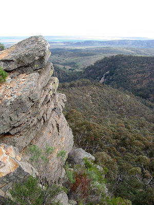
Having just returned from four months travelling around Western Australia and the Northern Territory - hiking over 600km of trail through gorges with waterfalls - I was a little surprised by how much water we saw in Mt Remarkable National Park, and, by how much I enjoyed this hike near home.

Mt Remarkable National Park


I have hiked here three or four times over the past five years. I was impressed. Green was everywhere, the creeks flowing, even large waterfalls. Lots of roos munching on green grass. A winter wonderland.

A great weekend hiking a track I had wanted to do for a number of years. We hiked from Mambray Creek campground along Mambray Creek Track, over Black Range - climbing up 500 metres - through to the Racecourse Track in the shadow of Mt Remarkable summit. We walked along Spring Creek, strongly flowing, we crossed the creek more than a dozen times. In all, we did water crossings over twenty times, far more than I had done in the entire 1,200 kilometre Heysen Trail.

We spent the night at the very nice Grays Hut, in the Racecourse clearing. A modern hut built around the ruins of an old dairy farmer's hut.


Download kml file to view in Google Earth or adapt to use as a navigational aid in a GPS unit


Stats

Black Range Trek, Mt Remarkable National Park
Saturday Sunday
28/08/2010 29/08/2010
Mambray Creek campground to Grays Hut via Sping Creek Grays Hut to Mambray Creek campground
Distance 22.1km 16.1km
Start Time 8.15am 8.20am
End Time 3.30pm 12.25pm
Moving Duration 4h50m 3h24m
Stationary Duration 2h30m 41m
Moving Average 4.2km/h 4.5km/h
Overall Average 2.8km/h 3.7km/h
Oodometer 22.1km 38.2km

Sunday, April 26, 2009

Mt Cavern Trek

Well two weeks ago Judith and myself found ourselves racing against the sun to return to camp before dusk fell. Today, we found ourselves wandering off the pathway and attempting to find our way safely down from Mt Cavern.

Mt Cavern trek, Mt Remarkable National Park


The second time in as many weeks we had found ourselves in a challenging situation. We needed to complete today's hike within a tight timeframe, but that mattered for nothing once we found ourselves off the pathway and lost. We backtracked a little but for a while, were certain we were still on track. Later, of course, it was obvious we had stumbled off the track, so we spent 30 minutes more or less in silence navigating our way down to the safety of the valley below.

A really fantastic hike though, despite the rain, mist and cloud on the way up to the peak of Mt Cavern, the views would be very good on a clear day. Despite what the signs said, I think there would be views from the peak. The walk down the other side of the Mount was truly breathtaking.
Mount Cavern Trek
(11 km return; 6 hours return. Or 3.6 km return; 2 hours return to Black Range Lookout only)
From Mambray Creek day visitor area, a demanding trek crosses the high ridges of the Black Range to the summit of Mount Cavern and then descends steeply into Mambray Creek. The view from Mount Cavern is restricted by tall trees but there are fine vantage points along the route. If your time is limited, an hours walk along the Mount Cavern Trek trail will lead to the Black Range Lookout. This lookout provides magnificent views of the plains and towns of upper Spencer Gulf. Return along the same route to Mambray Creek.


We had camped at Mambray Creek campground on Friday night, a stop-over for our drive up to Parachilna. Saturday afternoon, after our Mt Cavern trek, we drove up to Parachilna for the Shorts Outback film festival, held at the Prairie Hotel. Ideally, it is held under the stars with a gourmet feast, but due to heavy rains and wind over much of the state over the last couple of days, they went to plan b, using a marquee.

On Sunday we explored Blinman a little. This cute little one flew over the car almost immediately fluttering between each of the side mirrors in a seemingly unending obsession. Name it? Narcissus perhaps. Very cute.


Download kml file to view in Google Earth or adapt to use as a navigational aid in a GPS unit


Stats

Mt Remarkable National Park
Saturday
25/04/2009
Mt Cavern Trek
Distance 12.3km
Start Time 10.51am
End Time 3.07pm
Moving Duration 3h19m
Stationary Duration 55m
Moving Average 3.7km/h
Overall Average 2.9km/h

Tuesday, July 17, 2007

Seven Minutes Past Monkey

The monkey laughed, Dan, or a leader-by-proxy, had pulled it's legs - it now squawked with laughter. It was the signal, time to move out - in seven minutes anyway.

Alligator Gorge to Mambray Creek

Monkey featured highly in Dan's leadership style. This little toy monkey, with it's elastic legs, woke people who overslept and signaled the time to move out.

It was my first overnight hike - well, since PE camp in Year 9 - and my first hike with the Adelaide Bushwalkers. I had only recently joined this hiking club, in order to experience some overnight hiking and camping out, and to meet some new people - hopefully people my own age (the cross section of ages in the hiking club Friends of the Heysen Trail is older).

Yes, there were younger people. It was good. I also enjoyed the relatively organic style in which everything was organised, being a smaller club it is not as organised as the Friends of the Heysen Trail. This is good, more of a grass-roots approach.

We were hiking in Mt Remarkable National Park, from Alligator Gorge to Mambray Creek. There were two overnight camps, and two days of hiking. With 17 hikers, we divided into two groups, one group spending Friday night camping in the north, at Longhill Camp near Alligator Gorge, and the other group camping in the south, at Mambray Creek.

I grabbed a lift with David, and Jeff and Karen. We parked our car, and in the dark hiked a few hundred metres down into the valley to our campsite. The forecast temperature was a mere four degrees, but it didn't feel that cold yet. We joined the others and set up our tents, people seemed impressed with my $70, 2.05kg hiking tent. Best value-for-money. The next morning we hiked north through Alligator Gorge, up past The Terraces and out of the gorge to The Battery. It was tough, but mostly due to the 16kg pack I was carrying. Even though I thought I had my waist belt tight, it wasn't until the following day, with my bruised shoulders, that David show me a few tricks to get it even tighter - so it would carry more load and be much more comfortable.


The views from The Battery were spectacular, much better than the views from The Bluff back on the Heysen Trail in the south. From our vantage on the spectacular escarpment, we could see to the head of Gulf St Vincent, to Port Augusta and Baxter Detention Centre, and across the gulf to Port Lowly. Wow. It was an awesome view.


We reached camp after climbing down the steady but long Fricks Track to Kingfisher Flat. We met the other group who had hiked up from Mambray Creek in the south. It was a cold night, no fires were allowed in the national park except in Mambray Creek. Unusual for a national park.

The next morning we parted ways again, hiking down to Mambray Creek via Hidden Gorge. We had swapped keys that morning, so we grabbed each others cars and rendezvous at the bakery at Stone Hut. The food and beer was to it's usual excellence (the Coopers Pale Ale was a little old though), and the staff were in their usual grumpy form (don't let that put you off - the food and atmosphere is fantastic).


View Google Map in full-screen mode