Showing posts with label Simon. Show all posts

Sunday, April 22, 2012

Mawson Plateau traverse

A remote wilderness area in the Northern Flinders Ranges, the Mawson Plateau is almost untouched by people and their activities. There are no roads or tracks, no buildings or fences, and unlike much of the Northern Flinders Ranges, no history of mining.
Mawson Plateau, Northern Flinders Ranges

SUMMARY - Mawson Plateau traverse
Start Mt Shanahan - northern tip of plateau where Granite Creek meets Hamilton Creek. Dropped off by heli-charter from Arkaroola.
End Arkaroola
Time 6 days
Distance 90km
Mountain Ranges Mawson Plateau and broader Northern Flinders Ranges
Topographic maps 1:250 000 scale Frome SH54-10; 1:50 000 scale Yudnamutana 6737-1; 1:50 000 scale Wooltana 6737-2
Pastoral Stations Mt Freeling Station; Arkaroola Wilderness Sanctuary
La Nina, one of the weather phenomenons that so drastically affect Australia's weather patterns, brought the gift - as she is wont to do - of a huge downpour of rain to the deserts back in early March. Over five days 247mm fell at Arkaroola. It brought the rain we needed to make this hike possible. There are no rain gauges on the Mawson Plateau, which is a couple days walk north of Arkaroola Village, but it is thought that rainfall on the plateau is similar to the Gammon Ranges, both being of higher elevation than Arkaroola Village, so more rain falls.

Almost all the dirt roads across outback SA were closed in the days after the March deluge, and many had to be graded to be reopened. This kept grader operators busy, so the runway at Moolowatana Station, the first station and servicable runway north of the Mawson Plateau, was still damaged. So like last year, we had to charter a helicopter to drop us out. More expensive, but being able to drop us almost anywhere it saved us two days walking in from Moolowatana Station.

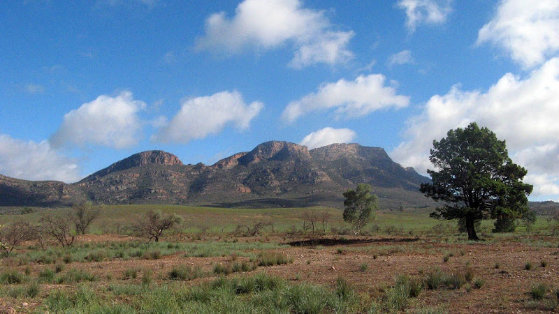
The plateau spans an area seven kilometres wide and 30 kilometres long. The area is littered with large areas of exposed granite, capturing water in numerous rockholes. Granite Creek and its many tributaries drain the plateau, flowing to the north to meet Hamilton Creek before making their way out to Lake Callabonna - one of the many large salt lakes that form a horseshoe around the Northern Flinders Ranges. Its highest point is Freeling Heights, a bluff on the south-western corner of the plateau. Originally the plateau was named Freeling Heights, but was later renamed in honour of Douglas Mawson.

The plateau is largely untouched, it's quite hard to find any sign of human impact. There are no roads or tracks, no buildings or fences, quite possibly no weeds (I've heard tell, I'm no expert), and little impact from feral animals, even goats (which are rampant in the Gammon Ranges to the south.) We found a couple of stardropper stakes in a clearing on our way up to Freeling Heights, marking the site of a government photo survey of vegetation. On stardroppers, one of the waterholes on upper Granite Creek is called Star Dropper Waterhole, so named after the single stardropper there that marks a corner boundary of the Arkaroola and Mount Freeling pastoral leases. We knew of this waterhole, we had seen photos, but did not know its exact location as the pastoral lease boundaries are not usually shown on the topographic maps. We did, unbeknownst to us at the time, see the waterhole on our return from the summit of Freeling Heights. In the back corner of a photo of the waterhole the star dropper can clearly be seen!

A single old track makes a small incursion on the plateau just south west of Mt Shanahan, an old mining track, the type such as litters the Northern Flinders Ranges. Without maintenance these tracks suffer from washaways and soon become undriveable. This one stretched a few hundred metres onto the plateau. It's unusual to hike in the Flinders Ranges somewhere that no 4WD could possibly travel, or has ever travelled.

There were are few other signs of human impact. Behind a rock above the Tee Junction Waterhole, one of the few permanent waterholes on the plateau (after decent rains it is thought to last ten years or so) we found an emergency cache of food and essential items. You know the essential things one might need: coffee, chocolate, cigarettes, toilet paper. From the logbook it seems to have been first placed there by Reg Sprigg in 1987, and has been well stocked since, very little was out of date. As the permanent waterhole, and one of the few named ones, it is a popular spot with hikers to camp at. That said, there were few entries in the logbook, but that may be due to hikers, such as us, not knowing the cache was there; we stumbled upon it on our second night there.

A couple of old stone cairns built by surveyors mark summits, there is one on Mt Shanahan, a summit which seems remarkably insignificant, and on Freeling Heights. Towering drystone structures, they never cease to amaze me in how well the surveryors of old constructed them. The Freeling Heights one, like all good summit cairns, is complete with a logbook of sorts, in this case loose paper in an old jar. Of all the notes in there, and there were not many - it seems there was only one, sometimes two, visits each year. Some year had no visits. Tafe was a common visiting party - the outdoor education course - they also featured quite well in the cache at Tee Junction Waterhole. Up at the Freeling Heights summit there were several cleared campsites, perhaps most clearly noticable by the large slabs of stone that had been carefully positioned to form chairs and even side tables.

The March rains filled all the rockholes, even after seeing so many waterholes we did not grow tired of them. It's hard to imagine what hiking here might look like in drier times. The waterholes were often an obstruction, a few times we had to scramble around them, many times over and around them. There were upsides to this though, by lunchtime on the first day we were already swimming in a vast waterhole. Every day on the plateau featured a good swim.

On our second day we decided to leave Granite Creek, with its many obstructing waterholes. We followed a spurline for two kilometres up to the escarpment edge, from here we had dramatic views over the eastern plains and Lake Frome. Following the escarpment to the south west, the escarpment grew increasingly dramatic. We crossed back across the plateau, which was no easy navigation task, to Granite Creek and its rockholes.

The views from Freeling Heights were also dramatic, we had a very clear day, one of the clearest I have seen up there. We could easily see Mt Painter, which we climbed in 2011, and further south Benbonyathe Hill (2010), Mt McKinlay, Patawarta Hill (2009) - 110km away - and Rawnsley Bluff on Wilpena Pound - 180km away.

On the fourth day we hiked to the escarpment, dropping off 400 metres in elevation down a long spur line to a creek. From here we followed it downstream to the hot springs at Paralana. The days were all hot, and most sunny, and we often sought out the shade of trees, no matter how small. A Paralana Hot Springs we sat in the cool reeds beside the hot flowing spring water. It was here we saw our first people since leaving Arkaroola, a couple visiting the springs in their 4WD. An offer of a cold beer would have been nice. Alas, unrefreshed we hiked on in the hot sun.

We camped beside a waterhole every night, and it was only one night where we forewent a swim, in that case to preserve the water from contamination for drinking. Our last night was possibly the best swim, in Bararranna Waterhole. Here the creek was flowing and the waterhole large, it reminded me of some of the rocky vegetationless gorge waterholes in the Kimberley, it was enormous.

On the sixth day we sidled into Arkaroola, and showers, cool drinks, food and chairs. Ah the things you miss hey.


View in full screen format
Download GPX file - for use as a navigational aid in a GPS unit
Download KML file - view in Google Earth

TRACK NOTES - Mawson Plateau traverse
Download larger version of track notes
Label Location Grid Ref Time Note
Sunday 15/04/12
Start NE of Mt Shanahan GR 559 770 8.20am drop-off (15min flight from Arkaroola) on hill NE of where Granite Creek meets Hamilton Creek. Hike along Granite Creek.
1 waterhole on Granite Creek GR 542 747 12.01/1.05pm Lunch + swim
2 Break GR 535 731 2.05pm
3 Turn around - too far GR 533 726 2.50pm Gorge narrowing, gorge exit missed
4/Campsite Campsite day 1 GR 535 731 3.10pm. Day's hike was 9.2km/6hr walk Camp beside creek on sandy area beside large shallow waterhole
Monday 16/04/12
4 Campsite day 1 GR 535 731 7am Leave camp, hike up spur to escarpment (5)
5 Escarpment GR 547 717 7.56am Follow escarpment to pt 7
6 Break GR 538 700 8.50/9.18am
7 Leave escarpment edge GR 520 686 10.35/10.55am Begin to cross plateau from escarpment edge back to Granite Creek
8 Break GR 513 682 11.45/11.57am
9 Lunch at head of creek GR 505 282 12.25/12.55pm
10 Rockholes on Granite Creek GR 498 681 1.19pm Lots of rockholes here, continue up creek to point 11
11/Campsite day 2 Tee Junction Waterhole GR 489 678 2.15pm. Day's hike was 13km & 7h15m Explored further to tee junction, waterhole a few hundred metres downstream from junction.
Tuesday 17/04/12
11/Campsite day 2 Tee Junction Waterhole GR 489 678 6.50am Leave camp with daypacks for hike up to Freeling Heights summit and return to camp here again
12 GR 8.36am Proceed up southern arm of Granite Creek, contour around to more open flatter area to west. Yes got a little sidetracked turning too far north when cross-country.
13 Clearing GR 458 665 8.50am Break in open clearing. Proceed across clearing, then following creek lines to vicinity of 449 655. Proceed up spur to flatter ridge near summit
14 Freeling Heights summit GR 448 643 10.30/11.10am Summmit marked by stone surveyors cairn in SW corner of ridge. Numerous campsites near summit, some shady.
15 Clearing GR 457 664 12.35pm Lunch. Follow creek lines across clearing and open country. Easiest way is to continue following creeks into major Granite Creek. Last 1.5km into Tee Junction difficult due to waterholes.
11/Campsite day 2 & 3 Tee Junction Waterhole GR 489 678 2.15pm. Day's hike 16.9km, 5.5hr moving, 7.5hr total Camp here again for a second night.
Wednesday 18/04/12
11/Campsite day 2 & 3 Tee Junction Waterhole GR 489 678 7.10am Leave camp. Proceed up SW branch of Granite Creek to waterfall
12 (oops duplicated) Waterfall GR 479 667 8.07am Contour around hills beside creek, hills clearer than creek here
13 (oops duplicated) Break, clearing and stand of trees GR 473 655 9.09/9.27am Clearing in creek
13 (oops duplicated again) Escarpment edge GR 473 650 9.50am Proceed down long spurline
14 (oops duplicated) Start of steep spur GR 478 642 10.28am Continue down spur, this section is very steep
15 (oops duplicated) Hot Springs/Paralana Creek GR 484 630 11.40am/12.20pm Lunch in creek at base of long spur. Proceed downstream along creek to Paralana Hot Springs.
16 Paralana Hot Springs GR 499 607 1.45/2.15pm
17 Exit Yudnamatana Creek GR 483 588 3pm Proceed up Nicolls Spring Creek, go right at major creek junction after a narrow gorge
18/Campsite day 4 Camp north of Nicholls Spring GR 482 578 4pm. Day's hike was 17km, 5.5hr moving, 9h overall Camped beside two-step waterfall, pools of water under each, pink granite rock
Thursday 19/04/12
18/Campsite day 4 Camp north of Nicholls Spring GR 482 578 7.07am Proceed up creek
19 Nicholls Spring GR 477 573 Marginal spring, spent sometime verifying location
20 8am Spring found, returned to packs, continue following creekline up
21 Head of creek 8.45am Break. Proceed up to saddle and ridge, skirt around 450m peak, proceed down long spur to East Painter Creek
22 East Painter Creek GR 457 5444 10.30/10.45am Break. Follow East Painter Creek downstream to East Painter Bore and tank.
23 Old Mine Track An easier start to tackling Humanity Seat? No, doubt it, track not long enough.
24 11.30am
25 East Painter bore GR 479 521 12.00/12.40pm Bore and tank. Creek enters plains here. Proceed along 4WD track to Paralana Hot Springs road, south past Lady Buxton Mine for 1.25km, turn south-west along an Arkaroola 4WD track past White Ants Mine
26 Top of hill GR 469 492 1.40pm A real bastard this track. Why didn't we navigate around it? Continued down track.
27 Creek/Road T-junction 2.20pm Take south track to Bararranna Waterhole
28/Campsite day 5 Bararranna Waterhole GR 457 479 3pm. Day's hike was 19km, 5.5hr moving, 7.5hr overall. Very large waterhole in gorge. Two waterholes at present. Carpark at end of road, but road looks out of service since March rains.
Friday 20/04/12
28/Campsite day 5 Bararranna Waterhole GR 457 479 6.50am Leave camp, proceed along track back to Arkaroola, track follows creek
29 Echo Camp Waterhole GR 429 497 8.10am
30 Arkaroola Bore 9am Break
31 Arkaroola (reception) GR 400 455 10.15am. Day's hike was 14km, 3h moving, 3.5h overall

Monday, July 11, 2011

Three lil' hikes

Three lil' hikes - with steep hills - led by Simon


Three recent afternoon hikes which Simon led, we enjoyed some sunshine and rain and exploring some of the hills, and, of course, some tough hills.

Sturt Gorge

Sunday 19 June 2011

View in full screen format
Download GPX file - for use as a navigational aid in a GPS unit
Download KML file - view in Google Earth


Cleland Conservation Park

Sunday 26 June 2011
Found a tough new hill.

View in full screen format
Download GPX file - for use as a navigational aid in a GPS unit
Download KML file - view in Google Earth


Gandys Gully

Saturday 11 July 2011

View in full screen format
Download GPX file - for use as a navigational aid in a GPS unit
Download KML file - view in Google Earth

Sunday, April 10, 2011

Beyond the Heysen: Stage 3, Mt Hopeless to Arkaroola

Like last year, the La Nina weather effect transformed this hike - flowing creeks, full waterholes, green vegetation.

Mt Hopeless to Arkaroola, 7 days - 2/4/11 to 8/4/11


The average rainfall for Arkaroola for January through to March is 99mm, 375mm fell in that same period this year, and that on top of high rainfalls late last year, and a wet season the year before. Rain falls in this area during the summer months, the weather the left-overs of the wet season from the northern tropics of the continent.

This was a difficult walk, walking across gibber plain, along creeks, bush bashing along steep hills, hard to follow tracks and several summit climbs - difficult but all good.

The start point was Mt Hopeless, so named not due to it's diminitive size, but because the explorer Eyre declared it a hopeless situation. A giant horseshoe shaped lake surrounded the northern Flinders Ranges, blocking access to the north of the contintent. He was wrong, but it was a good while before anyone discovered that. It was not a continuous lake stretching for many hundreds of kilometres, but a series of lakes, which would have allowed Eyre to travel through them to the north of the continent. Alas, perhaps the mirage of a hot day tricked him. He had named Mt Hopeless before he even climbed it, it rises just 50 odd metres above the surrounding gibber plain, the last bastion of the Flinders Ranges. Arguably, it could be Mt Babbage to the south, I'm no geologist expert on these matters.

Access to Mt Hopeless was difficult, it is not that far off the Strzelecki Track, but due to the recent heavy rains it was only partially open. We had planned to charter a plane from Arkaroola to Moolawatana Station, just a day's hike south of Mt Hopeless, but their runway was rain damaged. A tourist helicopter service has just resumed it's season up at Arkaroola a couple of weeks ago, so we chartered that to fly us out to Mt Hopeless, which also saved a day, albeit at a greater cost - in part due to the two trips required, it was only a four seater, there were four of us and the pilot of course. We could have walked from Arkaroola north to Mt Hopeless, this finishing our six year adventure at the northernmost point of the Flinders Ranges, but it would be difficult for the helicopter to find us out there on the open gibber plain.

From 2006 through to 2008 I walked the entire Heysen Trail from Cape Jervis, south of Adelaide, to the start of the Flinders Ranges in Crystal Brook, through to the end of the trail at Parachilna Gorge. A week in 2009 we walked from Parachilna Gorge to Angepena Station, a week the following year we walked to Arkaroola, and now, we have completed that walk all the way to Mt Hopeless, a distance of some 1,500 kilometres.

The first three days walking was on a 1:250,000 scale map. It took some used to getting used the map reading, the map being five times smaller than the regular 1:50,000 most of the southern and more populated part of the state is mapped out in. The contours are only shown at 50 metre increments, I tell you, at that separation mountain peaks can hide in between those contours lines. The 1:50,000 map has 10 metre contour increments. It took us a day and a bit to reach the real mountains of the Flinders Ranges, those easily discernable from the gibber plains. Mt Babbbage, once suggested as the northern trailhead of the Heysen Trail - it was far too remote for that - was hidden between some of these contour lines. We realised this when we summited a false summit, which we knew to be a false summit, to see not one but two possibilities before us that might be the actual Mt Babbage summit, only one clearly shown on the map.

Mt Hopeless and Mt Babbage both had stone cairns on them, but both had collapsed. Photos from the 1960s showed the Mt Hopeless cairn as being taller than a man, now it was just a collapsed heap of loose stones. The logbooks for both, of which we know Mt Hopeless certainly had one, lay buried deep under the fallen stones. Dissapointing for us not to be able to write such an important entry into them. Later in the week we climbed the Armchair and Mt Painter, both had logbooks, although interestingly no-one had written in the Armchair logbook since 2006, indeed there were only three entries - all from 2005 or 2006, and no-one had written in the Mt Painter logbook at all last year, and we were the first for 2011. There were pens in the logbook box, so no excuse for someone who summited not to sign it.


The Armchair was a challenging hike, from the base it was difficult to establish how we would reach the summit at the top of the large bell-top that was the top of the mountain. Getting to the ridge a hundred metres from the summit seemed possible, if it were not for knowing that other people had climbed it I'm not sure I would have been keen to even try. When we reached the ridge, the base of the bell-top, we could zigzag up the bell-top, slowly spiralling around to the very top.

Hamilton Creek, which we walked along for three days, was flowing, a real treat that made our hike logistically easy. Not just that, but also very enjoyable, we swam in the cold, rock bounded waters of Terrapinna Springs, camping and swimming beside a waterhole. In Yudnamutana Gorge we camped beside a waterfall, the water flowing strong well above our heads. Each night, and often during the day's hike, we could easily find good water to refill our water stocks with. Others who have undertaken this hike before have had to rely on bores and either driven or flown in water drops.

We walked into Arkaroola after seven days, having seen no-one, not even footprints, no cars, just a single plane. The first person we saw, just as we walked in with our large packs, asked us if an old lady like herself could undertake a hike like we just did. I rather suspect she thought we had spent a couple of hours wandering out to the nearby Arkaroola waterhole, and not 130 kilometres from Mt Hopeless.


View in full screen format
Download GPX file - for use as a navigational aid in a GPS unit
Download KML file - view in Google Earth


Download our walking route drawn onto topographic maps.


Stats

Northern Flinders Ranges
Sat Sun Mon Tue Wed Thu Fri
2/4/11 3/4/11 4/4/11 5/4/11 6/4/11 7/4/11 8/4/11
Mt Hopeless to Twelfth Station Creek Twelfth Station Creek to Brindana Springs Brindana Springs to Mt Shanahan Mt Shanahan to Greenhill Well Greenhill Well to Clean Chaps Waterfall Clean Chaps Waterfall to Mt Gee/Mt Painter Mt Gee/Mt Painter to Arkaroola
Distance 19.53km 20.19km 17.16km 21.94km 18.67km 12.42km 18.71km
Start Time 8.30am 7.19am 7.37am 8.01am 8.02am 7.43am 7.48am
End Time 5.02pm 4.10pm 3.15pm 4.47pm 3.46pm 4.41pm 3.37pm
Moving Duration 4h31m 4h51m 4h34m 5h33m 4h44m 4h45m 4h59m
Stationary Duration 2h25m 3h58m 3h03m 3h08m 2h56m 4h11m 2h59m
Moving Average 4.3km/h 4.2km/h 3.8km/h 3.9km/h 3.9km/h 2.6km/h 3.8km/h
Overall Average 2.8km/h 2.3km/h 2.2km/h 2.5km/h 2.4km/h 1.4km/h 2.4km/h
Oodometer 20.2km 40.4km 57.5km 79.5km 98.2km 110.6km 129.3km
Temperature 21.7 21.8 22.4 25.4 26.9 27.8 28.9

Sunday, November 14, 2010

Tackling the Peaks of Wilpena

The plan was a simple one, walk into Pound, tackle some of the peaks on the south-western rim - pack light so we could camp at the summit or saddle. Easy. Flexible.

Wilpena Pound, Flinders Ranges National Park


The southern side of Wilpena Pound taken in 2009. This drought ravaged scene contrasts with 2010's very green season.

Photographer: The Sentimental Bloke

However. Simple it did not turn out to be. Our packs only weighed in around 13 kilos, we had some basic light-weight wet weather gear just in case of rain. But rain it did not, pour it did. On the Friday night, we camped in the carpark near Arkoo Rock. Some hours into the night the heavens opened and it rained, a lot. Unfortunately, one of our party's tents failed. It had had a long reliable life, but I guess the water proofing had just worn out, the heavy rain causing a dramatic equipment failure.

Not detered, we continued with our plan. We had some notes from others who had tackled the peaks - Beatrice Hill (1148m), Pompey Pillar (1168m), Dorothy Peak (1016m), Harold Hill (1073m) and Greig Peak (1044m). Most had tackled them from the inside, one from the outside of the pound. As it turns out, perhaps we too should have tackled it from the outside. The vegetation was dense, very dense, progress was slow - around 1km/h. From the track near Cooinda Camp we followed a creek west, then a ridge south, but I think it was more an exercise is slapping each other with wet laden branches in each other's faces than it was in hiking. By lunch time we had made little progress, the peaks around the rim of the pound were still shrouded in mist, there was no hope of drying out the wet sleeping bag. Our light weight weather gear hadn't feared too well either, it wasn't cold, but it could be a cold night if you have wet gear.

All these factors combined, it was unanimous, we retreated. We would return another time, better prepared. For one thing, it seemed prudent in future to bring other wet weather gear in the car, and leave it there, but have it there just in case the weather turns prior to leaving the carpark. Further research showed that people who had used the in-pound route had done so years ago, in drier seasons where vegetation had not had the opportunity to grow so thick, or where fire had cleared the vegetation.

Sorry, no GPS map this time around, no photos. Had a house break-in, lost it. Pity. Below is a generic map of the peaks of Wilpena Pound.

View in full screen format
Download GPX file - for use as a navigational aid in a GPS unit
Download KML file - view in Google Earth

Friday, April 16, 2010

Beyond the Heysen: Stage 2, Arkaroola to Angepena

Water. It had transformed this hike. We slept beside creeks, we could hear the water trickling. It was the first signigicant season for rain in 10 years, the greenest the area had looked in 20 years.

Arkaroola to Angepena, 11/4/10 to 15/4/10


The water almost kept us out. We had been monitoring the rainfall, there had been good rain in November, December and February. But as we packed our things on Thursday night and drove up Friday morning more rain fell, 80mm in Arkaroola and 100mm in Leigh Creek. By the time we reached Hawker all the dirt roads north of Blinman had been closed, the bitumen road to Copley closed shortly after. Waiting between road status reports, we did a short hike up Illuka Hill in Wilpena Pound.

Saturday night at the Hawker pub we were despondant. The roads remained closed, the extent of road damage was becoming clear, the roads wouldn't be reopening anytime soon. We were locked out of the best walking season in 20 years in the Gammons. We had missed out by just half a day from being able to enter, closed roads wouldn't affect us when we were walking.

A plan was hatched. Calls were made, deals done. We chartered a plane from Rawnsley Park to Arkaroola. We would hike in reverse, south-west back to Angepena instead of north-east to Arkaroola from Angepena. From Angepena we would get a 4WD tour operator to pick us up and drive us back to our cars at Rawnsley Park. After five days of walking the roads were sure to be open to allow the 4WD tour operator to access us. The flight and transfers came to just under $400 each. It was a unique time to walk in the Gammons, so we seized the opportunity.

Our plane trip took us over flooded creeks, a good sign as we were relying on creeks as our water source. From the Arkaroola airstrip we were driven to Arkaroola Village by Doug Sprigg and his son, an informative commentary along the way. It transpired he would have flown down and picked us up for a lot less than what we had paid as he is a smaller operator than the Rawnsley Park one.


After a last meal at Arkaroola, a pasty and chips, we set off on our five day trek into the Gammons and south to Angepena Station. We had quite some miles to cover on this first day as we had not departed until after lunch, as it was we raced the sun into camp. It was spectacular walking through the sunset. Yeah, it felt like we walked through it, we did not merely see it. It surrounded us, I spent quite some time walking looking at the clouds above me. There were three levels of clouds, each reflecting a different sunset colour. The higher wispy clouds shone orange, higher clouds shone bright yellow, the lower ones in shade. All this interspersed with patches of bright sky blue sky.

For five days we marvelled at how green everything was, months of good rainfall ensured the green extended everywhere. I hadn't been in the Gammons before, but it is similar to the Flinders, indeed, the rainfall is usually lower, and right now this land stood in stark contrast to the normal Flinders scene. The bright red rocky ground was covered in green vegetation.


With the recent rains creeks flowed, at our first campsite, Mainwater Well, the creek flowed past us as we slept. Surreal to hear trickling water. Walking along creeks we had to negotiate mud and debris, and something rarely required in South Austalia, we had to walk along some wet creeks in ankle deep water!

On our second day we made camp by midday, again by Mainwater Creek. Leaving our gear and heavy packs we climbed Benbonyathe Hill. The climb wasn't complex, but the vegetation, especially near and along the ridgetop, was dense. Lower down it was easy enough to walk through. Reaching the summit and the stone cairn, we found a primitive steel frame for setting up a telescope. In the 1960s the British and Americans sought out possible sites to set up a telescope, both Benbonyathe Hill and Mount Mackinlay were tried. A rough road was constructed up each. On our hike along the ridge we saw no sign of the road, fragments of it were allegedly still visible some years ago, although the road came from the south before travelling along the ridge, we had hiked up from the north before going along the ridge. The site chosen for the observatory was Siding Springs in NSW.

In the logbook at the summit we found a note left in 1986 by a school undertaking the Jubilee Trek. This was a trek undertaken from Mount Babbage, north of Arkaroola, to Cape Jervis. Each school did a section, this was done prior to the completion of the Heysen Trail. Just last week, upon returning from Kangaroo Island I had first heard of this walk, reading a plaque at Cape Jervis near the ferry terminal.

For the second and third day we followed Mainwater Creek through Mainwater Pound. After navigating through the pound using our map reading and dead reckoning skills using the GPS only as a double check, we made our way up a side creek to Yackie Waterhole to collect some water. From here we climbed out of the pound, camping up at Arcoona Saddle. We selected the best spot we could in the saddle to camp, clearing rocks and branches.


The following day we hiked along the ridgetops, seeing many campsites more suitable than the one we had camped at. A short distance from Gammon Hill we dropped our packs to reach the summit. Gammon Hill was an easy walk, the gradient is easy and the vegetation wasnt dense. Here we found the logbook canister, but it was empty for all but one note. It seemed the last people here had removed the contents in order to transcribe them, promising to return them soon.

From Gammon Hill we chased some goats along the ridgetops, passing by Arcoona Saddle before rapidly descending back to the plains and our campsite at Arcoona. Refreshed with tank water from the car accessible campsite, we made our plans for our final day.

Our last day we walked through Owieandana Station, recently purchased by Operation Flinders, sighting our first person in five days. We stopped by Painter's Baseline, a cairn erected by a surveyor in 1857 and used to undertake the first surveys on the area.

Reaching Angepena Station we found that the road out to Copley remained closed, but 4WD vehicles were using the road. We arranged our pick-up for first thing the next morning, and made ourselves comfortable in the newly restored Shearer's Quarters of the station, enjoying another spectacular sunset and star filled sky.

More photos to come from Nick and Graham


Download kml file to view in Google Earth or adapt to use as a navigational aid in a GPS unit


Download our walking route drawn onto topographic maps.


Stats

Beyond the Heysen: Stage 2 - Arkaroola to Angepena
Sunday Monday Monday Tuesday Wednesday Thursday
11/4/2010 12/4/2010 12/4/2010 13/4/2010 14/4/2010 15/4/2010
Arkaroola Village to Mainwater Well Mainwater Well to Mainwater Creek Mainwater Creek to Benbonyathe Hill & return Mainwater Creek to Arcoona Saddle Arcoona Saddle to Arcoona campsite Arcoona campsite to Angepena
Distance 20.5km 7.4km 9.4km 14.6km 16.3km 22.9km
Start Time 12:56pm 8:17am 12:22pm 8:19am 8:23am 8:25am
End Time 6:29pm 11:46am 5:12pm 4:29pm 5:15pm 3:17pm
Moving Duration 4h39m 2h18m 3h09m (5h11m) 6h04m 5h00m
Stationary Duration 58m 55m 1h18m (50m) 2h45m 1h51m
Moving Average 4.4km/h 3.2km/h 3.0km/h 3.1km/h 2.7km/h 4.6km/h
Overall Average 3.6km/h 2.3km/h 2.1km/h 1.8km/h 1.8km/h 3.3km/h
Oodometer 20.5km 27.9km 37.3km 51.9km 68.2km 91.1km

Saturday, April 10, 2010

Illuka Peak, Wilpena Pound

Waiting for updates to road reports, we decided to tackle on of the 1000 metre peaks on Wilpena Pound. Another peak for our KMclub.

Illuka Peak, Wilpena Pound


This hike started from the Arkaroo rock carpark on the outside of the pound, we walked first to the rock then off the track, up the pound wall through Moonarie Gap. The vegetation was dense, so our movement slow. We entered the gap, then passed over the saddle on the 950m+ hill to the south of Illuka Peak. But we were defeated, it had taken us more time than we though, and we were eager to return to Rawnsley Park in the early afternoon to check the road status report, eagerly expecting some of the roads north to Arkaroola to be reopened for our five day Angepena to Arkaroola trek.


Download kml file to view in Google Earth or adapt to use as a navigational aid in a GPS unit


Stats

Illuka Peak
Saturday
10/4/2010
Distance 7.8km
Start Time 9:33am
End Time 1:55pm
Moving Duration 2h29m
Stationary Duration 1h54m
Moving Average 3.2km/h
Overall Average 1.8km/h

Monday, July 13, 2009

Beyond the Heysen

It took two attempts to summit the optimistically named Patawarta Hill, two nearby mountains of similar height had achieved mountain status. And amongst them Patawarta was the most prominent. When we reached the cairn at the top we sought out the log book, stored in a steel container donated by ABW. "Sophie and Kelly were the only girls who didn’t cry, " a recent entry left by a school group of year sevens said. Oh ok, crying or not, there must have been an easier way up here then the way we came, so we sought it out descending by a different route.

7 days hiking, Parachilna Gorge to Angepena Station


Our first attempt the previous day had a few lessons contained within. We had made camp about 3.30 in the afternoon, set up our tents, and set out to walk along the flat pound floor, following the edge of the range until we reached a pre-determined spur, from where we would start climbing. Patawarta Hill would be ours within an easy hour. After climbing the spur for some time, we headed to the saddle that would get us to the summit, only to find ourselves looking at the cairn atop the peak from across a valley. Opps. We should been walking and comparing with the map, we ascended one spur too early. Map reading without a marked trail requires an altogether new skillset, one which none of us had except Simon.

Patawarta Hill was painted by Hans Heysen in 1932 in a painting titled The Land of the Oratunga, and the painting which supposedly* inspired Warren Bonython to walk the Flinders Ranges, which later led to the creation of the Heysen Trail. * Supposedly just means I haven’t researched this to verify it.

We were hiking for seven days beyond the Heysen Trail. The trail ends at Parachilna Gorge, 1200 kilometres from Cape Jervis where it started. Most of us had already finished the trail, and this mission was about walking beyond the marked trail. Warren Bonython inspired the Heysen Trail, the original concept being that the trail would follow the entire Flinders Ranges, from it’s southern point near Crystal Brook to it’s northern end at Mt Hopeless. The walk from Parachilna Gorge to Mt Hopeless would take about three weeks, this was our first week, the following two be tackled next year. There is no trail to follow, so some very careful planning is needed, especially in respect to water supplies. We camped along the way, carrying our packs, just leaving a car at each end of the week’s walk. We gained permission from station owners to walk across their land. We had carefully read Warren Bonython’s book, Walking the Flinders Ranges (published 1971, reprinted 2000) for potential route details.

We climbed a further two peaks, Mt Tilley and Mt Hack, which it must be said involved more map planning and map to real world comparisons. From the summit of each, clear sunny days allowed us to see the 100 kilometres to Wilpena Pound in the distance, the distinct twin peaks of St Mary Peak and Mt Boorong** clearly visible on the horizon. Every other direction other than south though, pretty clueless really as to what we were looking at, this was new territory for most of us. We were the first people to reach the peak of Mt Tilley in 2 years, although that was difficult to verify with certainty. Perhaps the truer statement would be that we were the first people to reach the peak of Mt Tilley carrying a pen, as the logbook box contained no pens. Again we descended by a different route, eager as always to explore this great land.

On our ascent we had stumbled across an emu, who only took it’s so called flight moments before reached it. It had been guarding it’s eggs, a half dozen or so large black eggs.

Our third peak, Mt Hack, reminded me of climbing Mt Ossa in Tasmania in that our final ascent was to a large gently sloping plateau that we wandered up to reach the stone cairn and the highest point. From here we marvelled at the distant Wilpena Pound, and looking north took guesses at peak names. Again we discussed our Peak Bagging Plan. I don’t want to go into too much detail yet, but Nick had the idea several weeks earlier that we should climb all of South Australia’s peaks over 1000 metres in height. A good idea, I thought, as we researched mountain heights on Wikipedia. Ten or so of them, seemed pretty easy. The only one I had already climbed was St Mary Peak, in Wilpena Pound. We have had year-long plans to climb Mt Aleck in Elder Range, and we had just climbed three peaks on this walk - all over 1000 metres. Simon, delighted with our idea, was kind enough to add half a dozen or so other peaks, also mentioning the dozens of unnamed peaks in the Musgrave Ranges. Back in Adelaide doing some more research, we have now compiled a list of 36 peaks over 1000 metres, confined to three locations – Wilpena Pound (and Elder Range just south of it), the Gammons (and the three peaks we just climbed to the south of them) and the Musgrave Range in the far north of the state which holds no less than 19 of the peaks. This has turned into an ambitious goal, one which will require great planning. Meanwhile we enjoyed the warmth of the sun and the views from Mt Hack. Scouring the logbook Steve was keen to get a glance of Warren Bonython’s entry from 1969. From an earlier logbook, now in small pieces, we found an entry from 1967, but finding Warren Bonython’s entry would require the careful skill of a fine art or antiquity restorer.

Our party numbered 5 – Simon, Graham, Nick, Steve and myself. Saturday we drove up, Nick and Steve leaving Graham and myself to set up the tents and chat amongst ourselves. We compared pack weights to confirm my suspicion that my pack was heavy. Much to my relief Nick’s proved to be heavier. After their three hour car shuffle, to ensure one car was left at the end of the week’s walk, and one here at the start, we drove down to Parachilna to have tea at the famous Prairie Hotel.

I think it wasn’t so much a week of walking but a week of comparing food. Nick had the yummiest and by far the most food, but also the heaviest pack. Steve on the other hand had next to no food (and somehow not the lightest pack either).

Graham bought a new super-lightweight air mattress, and every time he turned or moved on it as he slept everyone within 500metres could swear they were in a coffee shop listening to a coffee grinder if it were not for the lack of the fresh coffee smell. It took us the full seven nights to find a solution which didn’t involve banishing him to the far side of the valley.

For two of the days Graham strode out far ahead of us, somewhat courageous you would think given we were free-walking cross country without a track, trail or markers. On his second stride-out day we reached our determined point to drop our packs to ascend Mt Tilley, and Graham was nowhere to be seen. After scrutinising our maps to plan our ascent of Tilley and several name-shouts, he returned. The rest of the week he never strayed from the walking group.

Enjoyed some good campsites with pretty good water, perhaps they only bad one was Claypan Dam which even when filtered wasn't a great colour, but still tasted kinda ok. We filtered and treated all dubious water. Had lots of nice campfires, making a regular routine of wood collection. Collecting wood though was surprisingly easy, I think mainly because I am so used to camping in areas where people always camp, where they collect every last scrap of firewood within 500 metres. We had a full moon early in the week so star gazing was limited to the couple of hours after sunset and before the moon rose. Nothing like a starlit night camping to remind you of just how many stars there are to be seen.

Saw next to no-one if you choose to ignore the cavalcade of six 4WDs that passed us near Artimore Station. Geez these guys have never heard of car pooling? In Hannigans Pass that same day we watched a 4WD pass us, evidently neither the driver nor the passenger saw us all lined up against a nearby rock eating lunch. He stopped at the top of a hill and sauntered back down to have a closer inspection of an old rusty car nearby, still showing no signs of having seen us. Sweet moment. We saw no-one again until the Alan, the local farmer at Narinna Pound, sought us out by following our footsteps one night for a hello.

**Is it really Mt Boorong? I don’t think so, I will check that out.


Download kml file to view in Google Earth or adapt to use as a navigational aid in a GPS unit


Download our walking route drawn onto topographic maps.


Stats

Beyond the Heysen
Sun Mon Tues Wed Thurs Fri Sat
5/7/09 6/7/09 8/7/09 9/7/09 10/7/09 11/7/09 12/7/09
Parachilna Gorge to Oratunga 1st Spring Oratunga 1st Spring to Patawarta Gap Patawarta Gap to Narrina Spring via Patawarta Hill Narrina Spring to Clayplan Dam via Mt Tilley Clayplan Dam to Christmas Goldfield via Mt Hack Christmas Goldfield to Muglapena Gap Muglapena Gap to Angepena
Distance 17.7km 25.0km 15.0km 17.6km 19.5km 19.5km 7.4km
Start Time 12.25pm 8.21am 8.40am 8.42am 8.25am 8.39am 8.12am
End Time 5.17pm 4.45pm 4.05pm 4.12pm 4.50pm 3.03pm 10.00am
Moving Duration 3h46m 5h54m 4h40m 4h58m 5h14m 4h9m 1h35m
Stationary Duration 1h4m 2h12m 2h36m 2h19m 2h53m 1h46m 4m
Moving Average 4.7km/h 4.2km/h 3.2km/h 3.5km/h 3.7km/h 4.7km/h 4.8km/h
Overall Average 3.6km/h 3.1km/h 2.1km/h 2.4km/h 2.4km/h 3.3km/h 4.5km/h
Oodometer 17.7km 42.7km 57.7km 75.3km 94.8km 114.5km 121.8km