Showing posts with label Overland Track. Show all posts

Tuesday, December 23, 2008

The Overland Track: Entry #3 (of 3)

The five of us - Tim, Kate & myself and Andrea and Theo - have camped together for the previous 4 nights, and we have climbed Mt Ossa together. We have been doing everything together.

The Overland Track, Tasmania
6 day hike: this blog entry the 5th, 6th and 7th days
Sunday 21 December to Tuesday 23 December 2008
Kia Ora Creek to Pine Valley Hut to Narcisus Hut to Cynthia Bay


We had lunch on a tent platform at Windy Ridge Hut, a one-point something million dollar hut that no-one seems to stay at, instead having lunch there. From there we walked halfway to Narcissus Hut before taking a sidetrip to Pine Valley Hut. From Pine Valley we hoped to climb the Acropolis, some of our eager members hoped to walk that afternoon, allowing time the following morning to explore the Labyrinth. By lunch my feet had declared climbing the Acropolis that evening as a non-option.

As it turned out, the hike of 1.5 hours off the main track was exhausting and Pine Valley Hut couldn't come soon enough. The walk out to the main track the following day we found to be quick and easy - a sure sign of how exhausted we were the previous afternoon. The campsites at Pine Valley Hut were small and sheltered, with rain forest soaring high above us and a creek meandering through the campsite.

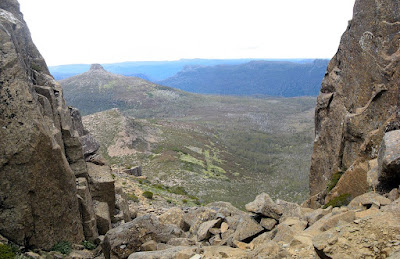
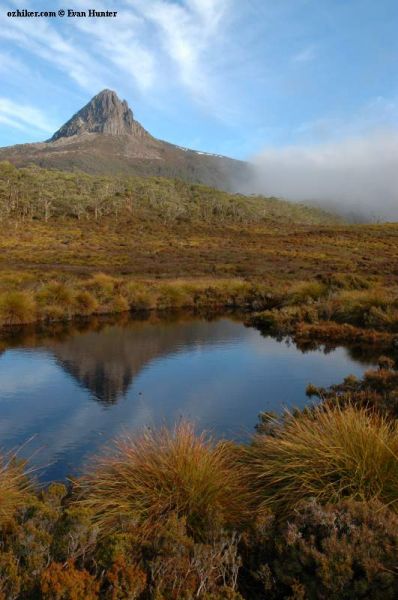
The morning of the 6th day, Tim, Theo and myself set off to climb the Acropolis as the girls had a well deserved sleep-in. The Lonely Planet guidebook said it was a 4 hour return walk, but the sign in the hut said it was a 5 to 7 hour return walk. We didn't have heaps of time, so decided to be back at the hut within 4 hours. The ascent to the midway plateau was very steep, and we reconsidered if we would still have time to make the peak from there. We decided to cross the plateau and reassess the situation. The Acropolis loomed closer, and with Tim's optimism it seemed to be close enough to achieve. There were a few difficult sections, but all in all it was easier than Mt Ossa had been. Again the peak was a plateau, and we had magnificent views of Mt Geryon and down to the Labyrinth. Despite the wind, we made our obligatory contribution to XXXXXXXXXXXXX (more details later) and returned to Pine Valley Hut. The final descent was steep and very hot, so I quite enjoyed my splash around in Cephissus Falls. We made it back to the hut in 4 hours and 4 minutes, where Kate and Andrea had prepared lunch.

The hike to Narcissus Hit was quite easy and flat. After confirming our ferry booking for the following morning via radio-speak in the hut, we set up camp beside the river. There were no tent platforms tonight, and despite the river it was a hot shadeless campsite. Once again Andrea got to see a snake as it crossed out campsite.

The following morning we walked the 300 metres to the ferry for the short trip to Cynthia Bay, where we all ate breakfast in the cafe before the bus trip to Hobart.


Alternatively, visit the Overland Track website to view the official Google Earth kml file. Download kml file to view in Google Earth or adapt to use as a navigational aid in a GPS unit


Stats

Overland Track:
Days 5-7
Sunday Monday Monday Tuesday
21/12/2008 22/12/2008 22/12/2008 23/12/2008
Kia Ora Creek to Pine Valley Hut Pine Valley Hut to Acropolis and return Pine Valley Hut to Narcisus Hut Narcisus Hut to Cynthia Bay
Distance 19.3km 6.5km 8.8km 300m (the rest by ferry)
Moving Duration 4h47m 1h53m 1h51m
Stationary Duration 1h13m 1h24m 24m
Moving Average 4.0km/h 7.3km/h 4.8km/h  
Overall Average 3.2km/h 1.9km/h 3.9km/h  
Oodometer 96.2km 102.6km 111.5km  

Saturday, December 20, 2008

The Overland Track: Entry #2 (of 3)

It was some climb to Mt Ossa, 4 hours return, and we weren't quite sure which mountain it even was. Was it this one in front of us (it was huge), or was it one looming behind somewhere?

The Overland Track, Tasmania
6 day hike: this blog entry the 4th day
Saturday 20 December 2008
New Pelion Hut to Kia Ora Creek


After climbing 150m from the main track up towards Mt Ossa we asked a passing tour guide who was bring his group back down. Yep, we couldn't see it yet, it lay behind the distinct mountain we could see before us. We had to go up, where we could re-evaluate.

"We've only climbed 300m, we still have 200m to go," I said to the others. "Yeah, we've climbed 300m, only 200m to go," replied Tim, ever the optimist. On we climbed up this mountain through a gully between two larger pillars of rock. It wasn't easy, I gotta tell you I was scared when I looked down. At the top of this formation I sat admiring the view. "I'll climb up there," I said, "it looks easy enough. From there we can see how much further it is to the peak." By this time Andrea and Theo had caught up with us, and Tim and Theo set off up the next ascent. I asked someone coming down how much further it was - I hate asking that - and it quickly became apparent that it was Mt Ossa that lay before us. So I raced up after the other two guys, climbing up through the snow patches, to reach the summit of Mt Ossa. The summit is a plateau, hence our reasoning as to why it wasn't Mt Ossa.


It was such a clear day we could see everywhere, and this being Tassie's tallest peak at 1617m, we were rewarded with views of peaks everywhere. I made a contribution to Theo's friend's website - a website Theo and his friends had all put in together for to pay for the programming and set-up costs as a birthday gift. Perhaps more on that later.

The descent was quick, just 45 minutes, and despite how scary the ascent was it was easy to return back down. We arrived at camp at 6pm at Kia Ora Creek, our tent platforms placed overlooking the creek with the sun setting on a distant rock face. After a refreshing swim - the waterfall was icy cold - we all ate dinner together and talked with the park ranger Jenny.


Alternatively, visit the Overland Track website to view the official Google Earth kml file. Download kml file to view in Google Earth or adapt to use as a navigational aid in a GPS unit


Stats

Overland Track: Day 4
Saturday
20/12/2008
New Pelion Hut to Kia
Ora Creek
Distance 14.4km
Moving Duration 3h45m
Stationary Duration 3h36m
Moving Average 3.8km/h
Overall Average 2.0km/h
Oodometer 76.8km

Friday, December 19, 2008

The Overland Track: Entry #1 (of 3)

It's the buttongrass. And the water. I'm sure of it. This is what makes this place so special. Almost fairytale.

The Overland Track, Tasmania
6 day hike: this blog entry the first 3 days
Wednesday 17 December to Friday 19 December 2008
Ronny Creek to Waterfall Valley Hut to Windermere Lake to New Pelion Hut


The Overland Track, it's a Designer Trail I tell you. Well, that's what I thought on the first day anyway. A shuttle bus to the start, boardwalks and graveled pathways, all through swamp, lush rainforest, lakes and mountaintop panoramas. But it ends, in mud, amongst the remnants of thirty year old rotten timber walkways. Water is everywhere it seems - always in abundance on the muddy track - but also in streams and lakes. For a South Aussie, it is at first unnerving only carrying 1L of water, but it seems everytime my drink bottle came close to empty another source of wonderfully clear water appears.

The view of Cradle Mountain on climbing to Marions Lookout is quite something, after a hard ascent the mountain suddenly appears before you. We were very lucky with clear skies, bad weather is common here it seems.

Day 1 ended at Waterfall Valley Hut, where we camped on the timber platforms above a waterfall. Andrea (pronounced On-dri-ah) and Theo, who we first met on the bus from Launceston, camped with us. Whilst we chatted, a couple of small spotted quolls explored our tents. None of us were too sure about how to set up our tents on the timber platforms with the cables instead of tent pegs. The strategically placed cables, and sometimes not so strategically placed, weren't so easy to master. How to keep the tension so the tent would remain waterproof if it rained. Luckily the first night it didn't, and by our second night we had learnt a bit because it not only rained, but snowed. The snow was special, it not so much fell as floated down onto our tents. At 4am when it started, I didn't care too much as the possums had been busy searching out food. But waking again later to a tent burdened with snow, I snuck a look to confirm my suspicions.

The view at the end of day 2 coming down to Windermere Lake was breathtaking, the yellows and purples. We saw two wombats, one crossing our path quite undisturbed by us.

Day 3 was longer at 17km. The view of Mt Oakleigh held us spellbound all day as we walked in a large arc around it. There was a lot of mud on this day, so our new gators were well used. They are so hot and uncomfortable which is why I hiked they whole Heysen Trail without any. Eewwk. But they are practical in the wet.

Tim and I went for a swim in Douglas Creek near the Old Pelion Hut. It was about a 20 minute walk from the new hut, maybe shorter if Tim hadn't worn his crocs there. The trail to the old hut was in very bad condition, but new timber materials lying stacked around indicated it was soon to be replaced. I think perhaps Tim needed the 4WD crocs we saw the park ranger Matt have earlier in the day. The swim was cold, but well worth it.

Again we camped with Andrea and Theo, the spotted quoll providing more amusement. The quoll soon lost interest in our tents, and upon hearing a group of guys playing hackie in the distant, it climbed upon a log to get a clearer yet distant view. Very amusing to watch.


Alternatively, visit the Overland Track website to view the official Google Earth kml file. Download kml file to view in Google Earth or adapt to use as a navigational aid in a GPS unit


Stats

Day 1-3: The Overland Track
Wednesday Thursday Friday
17/12/2008 18/12/2008 19/12/2008
Ronny Creek to Waterfall Valley Hut Waterfall Valley Hut to Windermere Lake Windermere Lake to New Pelion Hut
Distance 11.8km 11.0km 14.6km
Moving Duration 3h20m 2h35m 3h41
Stationary Duration 1h48m 1h04m 1h49m
Moving Average 3.5km/h 4.3km/h 4.0km/h
Overall Average 2.3km/h 3.0km/h 2.6km/h
Oodometer 36.8km 47.8km 62.4km

Tuesday, July 10, 2007

Introduction

I started getting into hiking back in 2006, and have been hiking the 1200km Heysen Trail from Cape Jervis to Parachilna Gorge in South Australia. I've been hiking a couple of weekends a month each year during April to October, I expect to complete the trail in August of 2008. All of my blog entries for this are located in a dedicated Heysen Trail blog.

Meanwhile, Kate and Tim suggested we hike The Overland Track, in Tasmania, in January of 2009. The Overland Track is a six-day, 65km trek through Tasmanian Wilderness World Heritage Area from Cradle Mountain to Lake St Clair.

We've done a little preparation for this carry-all-your-stuff and camp out trek, but we need to do a lot more yet. That "don't worry - it's 2 years away" complacency has set in! So I have decided to include some of this hikes here, some I've done with Kate and Tim, and some I have done with bush walking clubs.

Now, for a few inspirational photos of The Overland Track: