Showing posts with label The Lavender Federation Trail. Show all posts

Sunday, January 20, 2008

Wet Socks

Meh, not such an interesting day, walking with wet socks through too much farmland on the Lavender Federation Trail

Pyms Rd to Tungkillo


A 4.45am alarm. Beep-beep--beep-beep. A nasty noise, I'm sure you'll agree. I hiked today, like last Sunday, with Graham and Steve. They're both nuts, this can't be disputed. I already knew this before agreeing to walk some of the Lavender Federation Trail with them. Last week, we met on the freeway at 6am. I was smart that time, I helped Tim and Kate with their kitchen on Saturday, and slept over at their house in Nairne, so I could get up at reasonable time. The early start was allegedly to avoid the heat of the day. However, neither day got hot, and it rained on both days (although was not cold).

So I planned to walk a third day with them too, which would finish the trail in Springton, the current end of the trail (the trail currently starts in Murray Bridge, and is planned to finish in Clare, a distance of some 550km). Anyway, yep, that third day, meeting at 5.30 am in the morning on a pretty average hike, nah, I'll skip that thanks. I'll do it with the Friends of the Heysen Trail when they walk this section on 3 August.


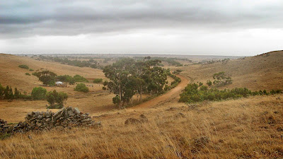
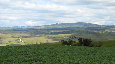
Yeah so today included some spectacular views from Mt Beevor, definitely the highlight of this section. Although... starting so early... there perhaps wasn't as much to see as the sign claimed. Beyond that to Tungkillo the trail was very much average, just farmland and fences. Although a quick tip for you, don't dress up in your favourite hay-bale costume, the cows will charge after you. Ok so I don't have a hay-bale costume, it's true, but that bright yellow backpack rain cover certainly attracted some unwanted interest - thankfully we were all armed with trekking poles. Otherwise I don't think I would be here to type this now... those cows were menancing.


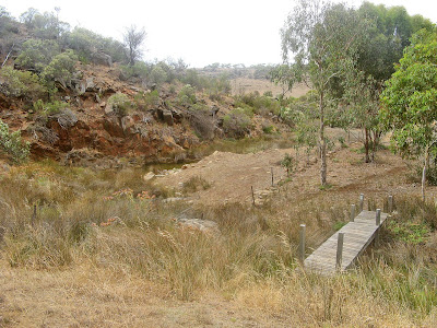
We had lunch near a creek, quite nice. A bit of a surprise. And we argued about how come we had already walked some 22km or so, and how come the walk was only meant to be 23km yet the car was still at least 7km away.


View photos as full screen slideshow


Stats:
  • Distance: 29km
  • Start time: 6.50am
  • End time: 1.22pm
  • Moving duration: 5h 31m
  • Stationary duration: 1h 01m
  • Moving average: 5.2km/h
  • Overall average: 4.4km/h

Sunday, January 13, 2008

Rainbow in a Sunrise

I've never seen a rainbow in a sunrise before. It was beautiful. Though I'm ashamed to admit it didn't occur to me it would rain.

Preamimma Mines to Pyms Road
Lavender Federation Trail


And rain it did. For the record though, the four of us walkers - Graham, Steve and Krystina - not one of us expected rain in early January. The weather forecast didn't include rain, so none of us had even the most basic rain protection. Thankfully, it wasn't very cold. And of course, by the time we finished and were driving back in the car, it was bright and sunny. As expected.


I think this is my favourite section of the Lavender Federation Trail. The first two sections I did, were ok, not great (Murray Bridge to Monarto, Monarto to Preamimma Mine).


Lots of water around too, which was a nice surprise. And lots of rocks too. Pity to see so much moss rock mining occuring, the pot-marked landscape wasn't so great to see.


View photos as full screen slideshow


Stats:
  • Distance: 23.5km
  • Start time: 7.20am
  • End time: 12:51pm
  • Moving duration: 4h 27m
  • Stationary duration: 1h 04m
  • Moving average: 5.3km/h
  • Overall average: 4.2km/h
  • Max speed: 11.9km/h

Sunday, August 19, 2007

Here's Hoping for Summer

Saturday was a clear, sunny day. Last weekend was hot. Obviously (?!), today would be likewise, so out with my really small backpack, shorts and a t-shirt. Not long until summer now, but was I getting ahead of myself?

The Lavender Federation Trail
Day 2: Monarto to Preamimma Mine


Well, it was, luckily, hot cos with my small backpack I hadn't packed anything much extra to keep warm, no rain stuff either. Everybody was rugged up when we met, ok, the morning was cold, but they all set out on the hike like it - jackets, beanies. And me? Shorts and t-shirt. Yes, it was cold in the shade, but not for long. Soon, everyone had those jackets, jumpers and beanies off, it was a clear, windless, sunny, warm day. Although someone did remind me it was, in fact, still winter, and not really that close to summer. But there was me longing for the hot summer days. Can I make summer come sooner by dressing summer-like? I think so (you may not).

Starting at the entrance to Monarto Zoological Park, we followed an old rusty railway. Yes, I've seen the Don't Play with Trains tv ads, clearly the railway could still be used, but it wasn't in too good a shape, so I walked along the tracks whilst the others walked along the track next to it.


Surprisingly, there were lots of photo opportunities today as we walked along little-used dirt roads and across paddocks and along creeks. Good views from Highland Road in both directions - to Mt Barker and over to the River Murray.


We walked across a paddock, past a sign that left us in no doubt we were not to wander off the trail at all, and hiked past the remains of Preamimma Mine, complete with a chimney, ruined buildings and some tailings. But we couldn't have a closer look, which was disappointing. Looking in the Google Map (map view) below you can see that the trail at this point is following a public right-of-way, but as is often the case with these trails, no actual road. Bev said she had read somewhere that this chimney was somewhat unique because of it's square base. From a quick google search, the remains are considerable, and it was an arsenic mine in 1854, 1862 and finally in 1899.
Website: www.aussieheritage.com.au.


An easy walk, but surprisingly scenic. Looking forward to future hikes along the Lavender Federation Trail, the next scheduled one is October 21 (2007). Pity they aren't more regular, I heard murmurings that perhaps George would seek to schedule some extra ones in during November.


  • Distance: 15km
  • Duration: 4.5 hours (9.45am - 2.15pm)
  • Weather: 17 degrees, clear, sunny (hoping for summer!)

Sunday, June 17, 2007

Just a 15km Hike

Just a 15km hike, pretty flat, not very interesting, a few tracks. Well, that's what we were led to believe. Perhaps George Adams was trying out some reverse psychology. Yes, it was pretty flat, yes, it was only 15km, yes, it was predominately tracks, but no, it wasn't boring.

The Lavender Federation Trail
Day 1: Murray Bridge to Monarto


The hike started after some car shuffling, starting at the Murray River. Even though it was about 9.15am, there was still a morning mist over the river, but it lifted quickly. I think it had been -1C here in Murray Bridge last night. After posing for some photos beneath the sign marking the official start point on the Lavender Federation Trail, we headed off along the old wharf area. Lots of history about: old railway locos and carriages, old riverboats - both floating and sunken - old bridges, old machinery and old buildings.


After leaving the wharf area we walked through the wetlands, and through some streets on the outskirts of the town out into the open farming land. We followed the Adelaide to Melbourne railway, stopping for a morning snack.


Next up was Rocky Gully - a real highlight of the day's hike. George led us the rock which features on the front cover of the official map, so we sent some people up to recreate the photo. We meandered through the gully, the creek and railway also meandered through. As we passed out of the gully, we ate lunch.

We walked past the Monarto Zoological Park, seeing some giraffes in the distance, perhaps also some bison (Bev saw some) and something else I can't remember.

George laid on some coffee and biscuits, as two cars were sent back to Murray Bridge to get the cars. Just in time too, not so soon after we all got into the cars but it started raining. Thanks for George organising today's hike, and organising the car pooling and lollies enroute - not to mention his contribution through South Australian Recreational Trails. A good hike.

Did today's hike through Friends of the Heysen Trail, and will do the next hike on August 19 (2007) and a third one this year on October 21 (2007).
  • Distance: 15.5km
  • Hike time: 4 hours

Saturday, June 16, 2007

The Lavender Federation Trail

The Trail
The 105km Lavender Federation Trail traverses the eastern flanks of the Mt Lofty Ranges, from the banks of the Murray River at Murray Bridge to the wine growing area of the Barossa at Springton in South Australia.

When complete, the trail is envisaged to continue over the Mt Lofty Ranges via the Barossa Range, past Angaston, Truro and Kapunda, to Clare, a journey of some 550km.


Trail Description
Beginning at Sturt Reserve, Murray Bridge on the banks of the Murray River, the Trail meanders past historic buildings, old riverboats undergoing restoration, past important wetland systems through to Rocky Gully Reserve on the outskirts of Murray Bridge.

This spectacular gully boasts steep rugged gorges with rocky outcrops and an abundance of native flora and fauna. At the northern side of Rocky Gully a loop trail provides rewarding views into the gully and a panorama across Murray Bridge. Allow at least three hours for this loop walk. Keep following the main trail and you may glimpse exotic animals as you pass the Monarto Zoological Park, an open range Bio Park.

Continue over grazing land and through forests to the eastern rim of the Bremner Valley. Then travel past abandoned stone farm houses, copper mines, along timeless creeks, over rock outcrops and ridges with views over the countryside.

The Trail makes its way to the summit of Mt Beevor, the most spectacular view of them all. To the north, the bush clad summit of Wirra Wirra peaks and the Barossa Range break the skyline, with glimpses of the Murray River to the east. On the edge of vision in the south, Lake Alexandrina stands out against the sand hills of the Coorong and the Southern Ocean while to the west, Mt Barker, Mt Lofty, Harrogate and the Bremner Valley complete the scene.

From Mt Beevor summit it’s a short walk via a spur trail to Diggers Rest north of Harrogate or continue to Tungkillo situated on the Adelaide to Mannum Road through quiet back roads, across creeks with an occasional glimpse of kangaroos. A loop trail north of Tungkillo allows a pleasant day walk or continue on the main track past spectacular rocky outcrops, open grazing country with views back to Mt Beevor and across the Murray Mallee. Gradually, glimpses of grapevines come into view as the trail reaches its current destination at Springton.

History of the Trail
The concept of the Trail came into being after a small group of walkers began to look for interesting walks in the hills to the west of Murray Bridge and found to their surprise a wealth of good walking country with high ridges, dramatic gorges, stately peaks and sweeping panoramas never before explored by walkers.

Since that time the idea of developing a trail between Murray Bridge and Clare has grown. Building of the Trail has been made possible with the financial and 'in-kind' assistance of State and Local Government authorities and local businesses and individuals. All track and administrative work has been performed by volunteers of South Australian Recreational Trails.

The Lavender Federation Trail is named in honour of the late Terry Lavender OAM, the architect of the trail and the first chairman of South Australian Recreation Trails.

Links