Showing posts with label The Heysen Trail. Show all posts

Monday, June 11, 2012

Dibber Dobber Dabber

Well no-one dibber dobbed, but we did finish off our three day trek hiking up Mt Dib and Mt Dab, and um, Dob, and a little of Deb. Leaving our campsite, we started our summit attempt on Mt Dab, until it became clear it was Deb, or at least not Dib or Dab. Progressing across the saddle to Mt Dab, then onto Mt Dib, which was most certainly Mt Dab... oops. Every time we reached a summmit we saw another, readjusting our minds to exactly which ones were Mt Dib and Mt Dab.

SUMMARY - Aroona Valley to Blinman Pools, return via Wild Dog Creek
Start Aroona Valley Campsite
End Aroona Valley Campsite
First Night The Cascades
Second Night Pigeon Bore
Time 3 days
Distance 57km
It wasn't the only navigational challenge we experienced, but our uncertainty added minimal distance to our three day trek. Navigation across the landscape is an element that makes a trek so good, opening up the possibilities of where we could go. Camping at The Cascades, a cross-country hike to Blinman Pools, hiking through the Wild Dog Creek canyon and summiting Mt Dib and Dab were the highlights of the weekend.


When we reached the Cascades mid-afternoon on Saturday, it was clear, even without a vote, that no-one was keen to continue on that afternoon to Blinman Pools. The Cascades were beautiful, it was clear, flowing water, the first water we had seen in a creek. Even more amazing, just a few hundred metres upstream, the creek was dry. The source was a spring - the water was warm, and there was plenty of it. We enjoyed our early camp with a camp fire and salmon and soft cheese crackers. Following the previous night's late arrival by bus, and our day's 20km hike, we retired early, to our already icy tents.

Sunday morning was cold, very cold, minus three. In the cold we set off with our daypacks, armed with Kate's 1:33 333 map and landscape familiarity from a recent rogaine, crossing the countryside to Blinman Pools. There was plenty of water in the pools, a stark contrast to what I saw when I was last here in the drought during 2007 - no horizon pool back then. The large, deep pool was irrestible, Ros and I jumped in for a swim - maybe the wrong verb, it was very cold, an instant brain freeze, so we scrambled out pretty quick.

We returned to our now dry tents, grabbing our packs and trying our hand at some creek navigation, always difficult in the Flinders Ranges. We lunched in a creek bed, each of us with varying degrees of lunch envy, before walking through Wild Dog Creek and onto the Heysen Trail, wandering south to Pigeon Bore. We made it in late, just after sunset, just managing to set up our tents before seeking out our torches.

We joined two other ABW groups around the fire, sharing our last rations of alcohol and chocolate.

Early on Monday, five dedicated walkers of the 12 strong group tackled Dib and Dab. We were rewarded with spectacular views of the Heysen Range, Wilpena Pound, and the landscape east all the way to Patawarta, all soaked in the early morning sun.

Maybe some more photos to come soon...


View in full screen format

Download GPX file - for use as a navigational aid in a GPS unit

Download KML file - view in Google Earth

Stats

Aroona Valley to Blinman Pools and return via Wild Dog Creek
Saturday Sunday Sunday Monday
09/06/2012 10/06/2012 10/06/2012 11/06/2012
Aroona Valley campsite to the Cascades The Cascades to Blinman Pools and return The Cascades to Pigeon Bore Pigeon Bore to Mt Dib and Mt Dab, return to Pigeon Bore then to Aroona Valley campsite
Distance 19.9km 8.33km 18.93km (total 27.26km Sun) 9.51km
Start Time 8.43am 8.08am 11.33am 10.04am
End Time 2.37pm 10.45am 5.33pm 11.05am
Moving Duration 4h04m 2h0m 4h19m 2h31m
Stationary Duration 1h34m 1h01m 2h09m 36m
Moving Average 4.9km/h 4.4km/h 3.8km/h
Overall Average 3.4km/h 3.1km/h 3.1km/h
Oodometer 19.9km 28.23km 47.2km 56.9km

TRACK NOTES - Aroona Valley to Blinman Pools and return via Wild Dog Creek
Download larger version of track notes

Sunday, February 6, 2011

Mylor to Aldgate circuit

A great half-day circuit, much of it within reserves, reserves I had no idea existed.

Mylor to Aldgate circuit


I had seen this walk on Everytrail by HeysenBarry. The photos showed a lot of reserve walking, I couldn't quite figure out how, but true enough, after following his GPS trace into a small path off of Stock Road, we were led through a long, peaceful reserve - the Valley of the Bandicoots (and more here) A few other dirt tracks, side roads, and then back along the Heysen Trail to Mylor. A good loop.

View in full screen format
Download GPX file - for use as a navigational aid in a GPS unit
Download KML file - view in Google Earth


Stats

Mylor to Aldgate circuit
Sunday
6/2/2011
Distance 10.9km
Start Time 8.28am
End Time 11.02am
Moving Duration 2h14m
Stationary Duration 10m
Moving Average 4.9km/h
Overall Average 4.5km/h

Sunday, October 17, 2010

Pewsey Vale to Greenock

A catch-up walk with Hilary, she is set to complete the Heysen Trail for a second time next year. We finished the Trail together back in 2008.

Pewsey Vale to Greenock


Today's walk was a sharp contrast to the conditions we did the original walk in back in December of 2007 when it was very hot.

Sorry, no photos or GPS map, stuff was stolen.

Sunday, September 26, 2010

Mt Bryan

Just a short wander up to the summit of Mt Bryan, doing some reconnaissance for another hike, so just drove along the roads at each end from Hallett and the old schoolhouse at Mt Bryan East.

Heysen Trail, Mt Bryan


View in full screen format
Download GPX file - for use as a navigational aid in a GPS unit
Download KML file - view in Google Earth


Stats

Mt Bryan
Sunday
26/09/2010
Distance 7.86km
Start Time 9.48am
End Time 12.22pm
Moving Duration 1h49m
Stationary Duration 39m
Moving Average 4.3km/h
Overall Average 3.2km/h

Monday, July 13, 2009

Beyond the Heysen

It took two attempts to summit the optimistically named Patawarta Hill, two nearby mountains of similar height had achieved mountain status. And amongst them Patawarta was the most prominent. When we reached the cairn at the top we sought out the log book, stored in a steel container donated by ABW. "Sophie and Kelly were the only girls who didn’t cry, " a recent entry left by a school group of year sevens said. Oh ok, crying or not, there must have been an easier way up here then the way we came, so we sought it out descending by a different route.

7 days hiking, Parachilna Gorge to Angepena Station


Our first attempt the previous day had a few lessons contained within. We had made camp about 3.30 in the afternoon, set up our tents, and set out to walk along the flat pound floor, following the edge of the range until we reached a pre-determined spur, from where we would start climbing. Patawarta Hill would be ours within an easy hour. After climbing the spur for some time, we headed to the saddle that would get us to the summit, only to find ourselves looking at the cairn atop the peak from across a valley. Opps. We should been walking and comparing with the map, we ascended one spur too early. Map reading without a marked trail requires an altogether new skillset, one which none of us had except Simon.

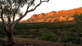
Patawarta Hill was painted by Hans Heysen in 1932 in a painting titled The Land of the Oratunga, and the painting which supposedly* inspired Warren Bonython to walk the Flinders Ranges, which later led to the creation of the Heysen Trail. * Supposedly just means I haven’t researched this to verify it.

We were hiking for seven days beyond the Heysen Trail. The trail ends at Parachilna Gorge, 1200 kilometres from Cape Jervis where it started. Most of us had already finished the trail, and this mission was about walking beyond the marked trail. Warren Bonython inspired the Heysen Trail, the original concept being that the trail would follow the entire Flinders Ranges, from it’s southern point near Crystal Brook to it’s northern end at Mt Hopeless. The walk from Parachilna Gorge to Mt Hopeless would take about three weeks, this was our first week, the following two be tackled next year. There is no trail to follow, so some very careful planning is needed, especially in respect to water supplies. We camped along the way, carrying our packs, just leaving a car at each end of the week’s walk. We gained permission from station owners to walk across their land. We had carefully read Warren Bonython’s book, Walking the Flinders Ranges (published 1971, reprinted 2000) for potential route details.

We climbed a further two peaks, Mt Tilley and Mt Hack, which it must be said involved more map planning and map to real world comparisons. From the summit of each, clear sunny days allowed us to see the 100 kilometres to Wilpena Pound in the distance, the distinct twin peaks of St Mary Peak and Mt Boorong** clearly visible on the horizon. Every other direction other than south though, pretty clueless really as to what we were looking at, this was new territory for most of us. We were the first people to reach the peak of Mt Tilley in 2 years, although that was difficult to verify with certainty. Perhaps the truer statement would be that we were the first people to reach the peak of Mt Tilley carrying a pen, as the logbook box contained no pens. Again we descended by a different route, eager as always to explore this great land.

On our ascent we had stumbled across an emu, who only took it’s so called flight moments before reached it. It had been guarding it’s eggs, a half dozen or so large black eggs.

Our third peak, Mt Hack, reminded me of climbing Mt Ossa in Tasmania in that our final ascent was to a large gently sloping plateau that we wandered up to reach the stone cairn and the highest point. From here we marvelled at the distant Wilpena Pound, and looking north took guesses at peak names. Again we discussed our Peak Bagging Plan. I don’t want to go into too much detail yet, but Nick had the idea several weeks earlier that we should climb all of South Australia’s peaks over 1000 metres in height. A good idea, I thought, as we researched mountain heights on Wikipedia. Ten or so of them, seemed pretty easy. The only one I had already climbed was St Mary Peak, in Wilpena Pound. We have had year-long plans to climb Mt Aleck in Elder Range, and we had just climbed three peaks on this walk - all over 1000 metres. Simon, delighted with our idea, was kind enough to add half a dozen or so other peaks, also mentioning the dozens of unnamed peaks in the Musgrave Ranges. Back in Adelaide doing some more research, we have now compiled a list of 36 peaks over 1000 metres, confined to three locations – Wilpena Pound (and Elder Range just south of it), the Gammons (and the three peaks we just climbed to the south of them) and the Musgrave Range in the far north of the state which holds no less than 19 of the peaks. This has turned into an ambitious goal, one which will require great planning. Meanwhile we enjoyed the warmth of the sun and the views from Mt Hack. Scouring the logbook Steve was keen to get a glance of Warren Bonython’s entry from 1969. From an earlier logbook, now in small pieces, we found an entry from 1967, but finding Warren Bonython’s entry would require the careful skill of a fine art or antiquity restorer.

Our party numbered 5 – Simon, Graham, Nick, Steve and myself. Saturday we drove up, Nick and Steve leaving Graham and myself to set up the tents and chat amongst ourselves. We compared pack weights to confirm my suspicion that my pack was heavy. Much to my relief Nick’s proved to be heavier. After their three hour car shuffle, to ensure one car was left at the end of the week’s walk, and one here at the start, we drove down to Parachilna to have tea at the famous Prairie Hotel.

I think it wasn’t so much a week of walking but a week of comparing food. Nick had the yummiest and by far the most food, but also the heaviest pack. Steve on the other hand had next to no food (and somehow not the lightest pack either).

Graham bought a new super-lightweight air mattress, and every time he turned or moved on it as he slept everyone within 500metres could swear they were in a coffee shop listening to a coffee grinder if it were not for the lack of the fresh coffee smell. It took us the full seven nights to find a solution which didn’t involve banishing him to the far side of the valley.

For two of the days Graham strode out far ahead of us, somewhat courageous you would think given we were free-walking cross country without a track, trail or markers. On his second stride-out day we reached our determined point to drop our packs to ascend Mt Tilley, and Graham was nowhere to be seen. After scrutinising our maps to plan our ascent of Tilley and several name-shouts, he returned. The rest of the week he never strayed from the walking group.

Enjoyed some good campsites with pretty good water, perhaps they only bad one was Claypan Dam which even when filtered wasn't a great colour, but still tasted kinda ok. We filtered and treated all dubious water. Had lots of nice campfires, making a regular routine of wood collection. Collecting wood though was surprisingly easy, I think mainly because I am so used to camping in areas where people always camp, where they collect every last scrap of firewood within 500 metres. We had a full moon early in the week so star gazing was limited to the couple of hours after sunset and before the moon rose. Nothing like a starlit night camping to remind you of just how many stars there are to be seen.

Saw next to no-one if you choose to ignore the cavalcade of six 4WDs that passed us near Artimore Station. Geez these guys have never heard of car pooling? In Hannigans Pass that same day we watched a 4WD pass us, evidently neither the driver nor the passenger saw us all lined up against a nearby rock eating lunch. He stopped at the top of a hill and sauntered back down to have a closer inspection of an old rusty car nearby, still showing no signs of having seen us. Sweet moment. We saw no-one again until the Alan, the local farmer at Narinna Pound, sought us out by following our footsteps one night for a hello.

**Is it really Mt Boorong? I don’t think so, I will check that out.


Download kml file to view in Google Earth or adapt to use as a navigational aid in a GPS unit


Download our walking route drawn onto topographic maps.


Stats

Beyond the Heysen
Sun Mon Tues Wed Thurs Fri Sat
5/7/09 6/7/09 8/7/09 9/7/09 10/7/09 11/7/09 12/7/09
Parachilna Gorge to Oratunga 1st Spring Oratunga 1st Spring to Patawarta Gap Patawarta Gap to Narrina Spring via Patawarta Hill Narrina Spring to Clayplan Dam via Mt Tilley Clayplan Dam to Christmas Goldfield via Mt Hack Christmas Goldfield to Muglapena Gap Muglapena Gap to Angepena
Distance 17.7km 25.0km 15.0km 17.6km 19.5km 19.5km 7.4km
Start Time 12.25pm 8.21am 8.40am 8.42am 8.25am 8.39am 8.12am
End Time 5.17pm 4.45pm 4.05pm 4.12pm 4.50pm 3.03pm 10.00am
Moving Duration 3h46m 5h54m 4h40m 4h58m 5h14m 4h9m 1h35m
Stationary Duration 1h4m 2h12m 2h36m 2h19m 2h53m 1h46m 4m
Moving Average 4.7km/h 4.2km/h 3.2km/h 3.5km/h 3.7km/h 4.7km/h 4.8km/h
Overall Average 3.6km/h 3.1km/h 2.1km/h 2.4km/h 2.4km/h 3.3km/h 4.5km/h
Oodometer 17.7km 42.7km 57.7km 75.3km 94.8km 114.5km 121.8km

Sunday, April 19, 2009

A little too far perhaps

31km each day, pack carrying. Yeah. A little too far perhaps.

Heysen Trail - Burra to Black Jack Shelter to Mt Bryan East


It was Graham's doing. I blame him. I don't want to talk about it right now. A couple of long days of pack-carrying. Met someone who went to school with my mum. Hurt my feet. Got to wear socks with sandals to work for 4 days. Not a good look.


Download kml file to view in Google Earth or adapt to use as a navigational aid in a GPS unit


Stats

Heysen Trail
Saturday Sunday
18/4/2009 19/4/2009
Burra to Black Jack Shelter Black Jack Shelter to Mt Bryan East
Distance 31.3km 32.1km
Start Time 8.36am 7.07am
End Time 5.25pm 4.16pm
Moving Duration 6h39m 6h49m
Stationary Duration 2h05m 2h21m
Moving Average 4.7km/h 4.7km/h
Overall Average 3.6km/h 3.5km/h
Oodometer 31.3km 63.4km

Sunday, August 17, 2008

The Heysen Trail - Complete

Yesterday I finished the Heysen Trail at Parachilna Gorge - a journey of some 1,200km from Cape Jervis. 64 days of hiking over the past 2 years.


Finished - August 16 2008 - at the end of the Heysen Trail at Parachilna Gorge

It seems a long time ago now, that fateful day when I started - April 30 2006. That morning was cold, I almost didn't bother getting up early.

It didn't go unnoticed today of my first End-to-End 2 weekend back in mid May 2006 when I hurt my knee on my first hike with that group. After six months or so of physio exercises, and lots of hike-bandaging and poles - well, let's just say I've come a long way since then.

It seems so surreal that I have finished the trail now, I can't imagine not doing it anymore. I might walk some days on the trail again with people, it may not be so easily done to untangle oneself from the trail. However I probably won't blog them here.

There may still some unfinished business looming with the Heysen Trail next year though, I'll get back to you on that one later. Secret squirrel.

The full blog of my 64 days on the Heysen Trail can be found here: www.jez-heysen.blogspot.com

Sunday, April 13, 2008

Newbies trying out Adelaide Bushwalkers

An easy weekend doing some pack-carrying hikes - ideal for beginners - with Adelaide Bushwalkers

Kuitpo Forest


Since I have only done one hike with Adelaide Bushwalkers (ABW) before, back in July in Mt Remarkable National Park, and with the new hiking season just started, I thought I would join in on this "beginner's hike". This year I'm doing two weeks with the Friends of the Heysen Trail, but apart from that only 3 other walks with them, and a handful of catch-up walks with friends so I can finish the Heysen Trail on August 16. So I will have more weekends available to hike with ABW, especially after August. I quite enjoy pack carrying, and camping out overnight. Also, there seem to many more young people in ABW than in the Friends of the Heysen Trail.

There were eleven of us, 6 beginners - Debbie, Joyce, Sam, Liz & Steve, and myself (who had hiked once before with ABW) - and the rest regulars. Debbie, Joyce and Sam were all pretty new to pack-carrying and camping out overnight. It was great to meet so many newbies, and I think they found much comfort in each not being the only one.

The hikes were fairly easy, only 3-4 hours each, although a little faster than I would normally walk with a pack. Of course the newbies found them more difficult, carrying a full pack isn't easy. There is also very little in the way of hills around Kuitpo Forest. On Saturday, once we had set up camp at Chookarloo Campground - nice - and I found one of the newbies using a very heavy item to in setting up their tent - no wonder the pack as heavy - we did some orienteering nearby with a map and compass. Pretty cool stuff, although thanks to the work of my secret agent my feet were bloooody painful by now.

Fun times that night cooking our meals, all the regular hikers getting a bit of a laugh watching the newbies try to master their hired trangiers, when we all had easy-to-use fuel cell burners. Cruel trick that. Still being the fire ban though we had no campfire, but sat around a candle instead - seriously - it was the only light though and surprisingly bright.

Sunday was easy hiking too, although Liz dragged it out a bit because we weren't that far from the cars, although that's a credit to the newbies though who were obviously coping well. For lunch we rendezvoused at the bakery in Meadows - nice one.

Hiking with ABW is cheap, the weekend cost us each $3 - the cost of camping in the forest. The newbies who hired their gear from ABW would have paid $3-$5 for each item (pack, tent, trangier) which is also very affordable.


Stats: Saturday
  • Distance: 14.7km
  • Start time: 10.00am
  • End time: 2.20pm
  • Moving duration: 3h 12m
  • Stationary duration: 1h 08m
  • Moving average: 4.6km/h
  • Overall average: 3.4km/h
  • Max speed: 8.5km/h
Stats: Sunday
  • Distance: 12km
  • Start time: 8.30am
  • End time: 11.30am
  • Moving duration: 2h 36m
  • Stationary duration: 24m
  • Moving average: 4.6km/h
  • Overall average: 3.9km/h
  • Max speed: 6.6km/h

Tuesday, July 10, 2007

Introduction

I started getting into hiking back in 2006, and have been hiking the 1200km Heysen Trail from Cape Jervis to Parachilna Gorge in South Australia. I've been hiking a couple of weekends a month each year during April to October, I expect to complete the trail in August of 2008. All of my blog entries for this are located in a dedicated Heysen Trail blog.

Meanwhile, Kate and Tim suggested we hike The Overland Track, in Tasmania, in January of 2009. The Overland Track is a six-day, 65km trek through Tasmanian Wilderness World Heritage Area from Cradle Mountain to Lake St Clair.

We've done a little preparation for this carry-all-your-stuff and camp out trek, but we need to do a lot more yet. That "don't worry - it's 2 years away" complacency has set in! So I have decided to include some of this hikes here, some I've done with Kate and Tim, and some I have done with bush walking clubs.

Now, for a few inspirational photos of The Overland Track:


Monday, April 9, 2007

Camping in Aroona Valley

Some photos of a camping trip into the Flinders over Easter, camped in Aroona Valley. Not strictly hiking the Heysen Trail, but a weekend of camping and hiking with a couple of friends. We walked a couple of small Heysen Trail sections near Aroona Valley, but also walked through Wilpena Pound to Malloga Falls in Edeowie Gorge, and to the Blinman Pools.

Here are the best 44 photos from the 300 odd photos taken (thanks to Tim for some excellent photos and photo taking expeditions). Might return later to write some funny comments and stuff...

Here I am back...

I really should have had some idea. I had been here before in the Flinders - for the first time - just a couple of years ago. We had driven along roads then where it was difficult to determine whether you were driving in a creek or on a road. It was 11.30pm at night, we had left the city at 5.15pm on Thursday keen to get out camping so we could enjoy every day of hiking. So like I said, it was late, and we still hadn't made camp, we were slowly driving along a creek - or road - or whatever in our little Ford Focus. Tim skillfully steered the vehicle around the rocks, whilst Kate skilfully provided warning and varying "eeks" as feedback to Tim's driving success. I hadn't been on this particular road before, but even in the dark it was spectacular - Brachina Gorge. If you like rocks this would be heaven. I think rocks are pretty. Tim later declared the Flinders as a diverse and rugged part of SA - all good. That's a good evaluation I think. Stunning geography, sunsets and camping.

Anyway, having paid our entry and camping fees at the self registration point, we snuck past the Campground Hosts. We had chosen to set up camp in Aroona Valley because of it's close proximity to various walking trails. We arrived past 12, and set up the tent without the fly or pegs, keen not to wake other campers. Kate pointed out that my method of closing the car doors was not consistent with that intention...

Next morning I took some sunrise photos, exploring the ruins of Aroona homestead. We finished setting up the tent and set out for a hike along part of the Heysen Trail. I've lost my map so I'm not quite sure what the loop trails we hiked were called, but we saw some really impressive stuff - including huge spiders - and got a bit lost. We walked about 11km, spending the arvo resting.

The next day we hiked through Wilpena Pound to Malloga Falls in Edeowie Gorge. Spectacular stuff. Being 23km, hikers were advised to allow 9 hours return. We did it in 6 hours. We were advised the track was unmarked, but it was marked with the same markers as elsewhere, marked every 200 metres, but piles of stones, footprints and arrows in the sand helped us find the way through the overgrown foliage. Kate really found her strength here, both Tim and I being taller seemed to cop more of the foliage in our faces. We were also informed to be wary of falling hikers from the clifftops above. We didn't see any. The falls were dry, just one stagnant pool. Found some disorientated hikers on the way back. We kindly informed them it was "a mere 8km" in the opposite direction back to the Pound entrance.

The mentally awful songs - not one finishing before another started - drove us off the information centre patio immediately after our icecreams were finished. Sawing our one bar of soap into portions we paid for a hot-warm-cold-warm-cold shower in the Wilpena campground - nice. Kate's shower was hot-hot-hot. Go figure. Regardless, rather appreciated the new smell (or lack of bad smell). Drove back to camp along the Bunyeroo scenic drive whilst the sun set - some cool photos and a resolution made for Tim and I to return next morning for sunrise. Tim reckoned the colours would reflect more spectacularly during sunrise - he was right. Clever maths man. We left camp at 5.30am and got some pretty cool photos. It's fun to have a photo partner. Loving my new camera, so much better than my old one. The following morning we climbed up a hill in Aroona Valley and Tim got some top shots of the sunrise on the Heysen Ranges. Must've been a good idea as we were joined by 3 other people for the same purpose, who later seemed to be contenders as spectators for Tim and I to shower under a fire hose fed by the local spring. Got to admire one of them though, getting up early, then climbing the hill to take photos with her broken camera, quite unsure if her photos would work. I reassured her it looked like just a cracked LCD screen, and she then seemed happy that the people at the photo shop would still be able to develop her film (in her digital camera!?!)

Over confident from our previous day's quick walk, we thought today's 5 hour hike to the Blinman Pools would be an easy 3 hours. It was already late in the morning. We thought we were close to the First pool, 5km in, when we reached the half way sign. Our confidence was shattered, and we were pretty tired from the previous day. Apparently 8-10 hours sleep wasn't going to save us. We psyched ourselves up to finish the walk - I found solace in eating, the others by gloating that later they would eat as I enviously watched on having already consumed all my rations. Whatever, there's nothing wrong with slurping a freddo frog out of it's wrapper like an ice stick (it was like 30 degrees). Near one of the larger and more inviting pools we found a family lost in giggles, seriously - they were. Standing behind a tree was an embarrassed girl tightly clinging to the towel around her, I think she felt quietly confident no-one else would be coming along. Beyond this pool we found that the official First and Second Pools weren't as inviting. The Second Pool was drying up, the First fed by a spring but still not so inviting. Tim tested out the durability of his new metal water bottle by dropping it from a cliff. It passed. Eating an icecream later at the shop in Angorichina Village we found a much better map than the rubbish one we had - one that would have allowed us to take short cuts on the way back!

Tim managed to re-establish his love for photographing kangaroos, a given both Kate and I had experienced long ago in Deep Creek. He got some good photos though, roos are such funny creatures, we got very close once when we stumbled across some unawares.

Enjoyed some good food, good wine, good beer and some good times. A very warm weekend, high 20's. Kept up our uncanny matching clothes to the end. The Focus proved to be an excellent car, I'm sure in part to Tim's skillful driving and Kate's always at hand feedback, but we saw many 4WD drivers being more hesitant with their cars. Typical. We should have had the right to swap cars. We drove home in 6 point something hours, a good run compared to our 7.5 hour drive there. Apparently previous clogged Pt Wakefield Road Easter experiences caused everyone to be fraidy cats and stagger their driving throughout the day. Nice. The jerks still drove at their regular time though. Disappointed to see survey markings out in preparation to seal the dirt road from Wilpena to Blinman, it can only mean the driving will get worse, and take a little of the magic away from the Flinders and the quaint town of Blinman. This hiking weekend renewed my love of hiking. I was thinking of not continuing hiking the Heysen Trail this year. I dunno, whatever. But I'm keen to hike and as always, camp.