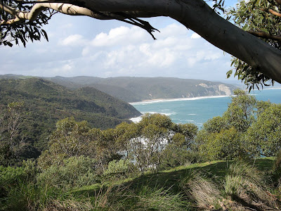
A 700-metre ascent from a humid, fern-filled valley onto an alpine summit could not be more of a contrast. Mt Bogong, Victoria’s highest peak at 1968 metres, lies in the Victiorian Alps near the 50s town of Mt Beauty.
Mt Bogong, the High Country, Victoria
The final of three blog entries for a week spent around Canberra doing three of the State 8 peaks - the highest mountains in each of Australia's eight states and territories.
SUMMARY - Mt Bogong hike
Start
Mountain Creek Picnic Area
End
Mt Bogong summit, re-trace steps to Mountain Creek Picnic Area
Time
3h15m up, 2h30m down
Distance
7km each way
Elevation gain
1370m
Topographic maps
1:30 000 scale, T8324-1-3-S
The alpine environment of Mt Bogong was quite different from the alpine environment of Mt Kosciuszko. Bogong has quite a lot of prominence, how much it rises above country around it. So the alpine area around the summit is small, contrasting with the large alpine area that surrounds the rather indistinct Kosciuszko.
Mt Bogong was the third peak on the week’s list of the State 8 summits – the highest peak in each of Australia’s eight states and territories.
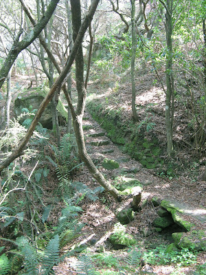
Starting from Mountain Creek Picnic Area, we hiked up the aptly named Staircase Spur. The most direct route, so the steepest, with a few short sections that taper off the constant ascent. We hiked up in the warm, humid afternoon to the halfway point, Bivouac Hut. The noisy school kids didn’t put us off for long, we set up our tents in the large clearing beside the hut – the hut itself is quite small and designed for emergency use. It does have a wood heater though, and a water tank. We did try and look further afield for some tent spots, but being on a steep spur halfway up a mountain meant there were limited camping options, so we settled down with the teenagers instead. Lightning rolled around us the sun set, but we sat outside cooking dinner as the rain spared us.
The following morning, with the summit shrouded in mist, we set off again to the top. Conditions changed as we got higher, we walked past the treeline into the cool breeze, and then into the mist. Nearing the summit paths led off to the right, but in the mist it may have been certain death, so we continued along the snow poles to the ridge, then walked the short distance to the summit. Marked by a large stone cairn which provided us with shelter from the strong, cold winds, Vicki did her little summit jig. We were thankful we had brought along extra clothes, not needed back near the hut but a life-saver up here. A small blue spot emerged through the clouds in the sky above us, but we soon gave up on waiting for any clearing of the weather, and instead started heading back down.
Finishing back at the cars Mountain Creek Picnic Area, we sniffed out a dozen tents that appeared, absent of people and cars, before enjoying a swim in the freezing waters of the creek.
I may have previously said some evil things about this walk, I take all those things back. Having now completed the 250km trail, it is, upon reflection of its entirety, the Great South West Walk is a fantastic trail. It is spectacular, with good facilities and well maintained.
We walked the eastern 100km back in Easter, and have just walked the remaining 150km western section. At Easter we walked from Moleside, down the Glenelg River to Nelson, then along the beaches to Mt Richmond. This time we walked from Mt Richmond, along the coastal cliffs and headlands to Portland, then through the forest back to Moleside.
The coastal section here is spectacular. The coastal section from Nelson to Mt Richmond had been dominated by long walks on the beach, perhaps that sounds like something from a dating website, but about half of the beach is avoidable with alternative inland routes. This trip's section was dominated by clifftop walking along headlands, and short beach sections in small bays. It is spectacular. A narrow national park follows much of the coastline. The waves pound at the base of the cliffs, so there is always something good to watch with awe-filled eyes, until a general giddiness and and lack of head-for-heights drags you back from the cliff edge. Much of this area has been formed by volcanic action, so there are different rock types which add much interest.
Our first campsite, at The Springs on Cape Bridgewater, provided a fascinating insight into local geology. Where were the springs, I wondered. The last place I expected! The fresh water is to be found on the large rock platforms a little above where the waves crash, at the base of the coastal cliffs. Yep! I did wonder how the water got that high. Freshwater seaps out of the cliff onto the rock platforms, some of the volcanic rocks is impenetrable, so it flows out horizontally to the cliff edges.
There are many wind turbines along this coast, but on the upside, and much to Graham's disappointment, popular opinion sees them as better to look at than a coal plant. If you are a bit down on not seeing a coal plant though, take heart, walking into Portland you walk three sides of a large aluminium smelter. Curiously, who knew this, depending on where you read though, this single smelter uses 18-25% of Victoria's electricity. It looms large on the horizon, quite why it is sits on a prominent headland I'm not sure, but clearly it needs to be close to the port facilities of Portland, and the large conveyor belt disguised as a massive pipeline from the port to the smelter gives a few clues as to why I suppose. Don't be discouraged though, it is only seen for one day, and if you pivot your head to the right the coastline is still spectacular, the first half of the walk out of Mallee campsite is stunning, you hardly notice the plant. And it's not like we don't all use aluminium, at the very least much of our hiking gear is made of it.
The track is well maintained. We met quite a few locals who knew someone who got out and maintained the trail. Much of the trail in this area needs to be mowed, yes, that will sound strange to a South Australian, but indeed it is mowed, and foliage cut back. The trail is well signposted, we had no trouble following it. There are many interpretive signs along the way, I really appreciated these, so many fascinating things to learn.
A good map, better than the map on the Great South West Walk website, is the map produced by Cartographics and Meridian Maps. It's 1:50 000 scale, topographic, recent, and very accurate with lots of good info marked. It can be purchased online or locally at Portland at the Portland Visitor Information Centre or Davis Newsagency.
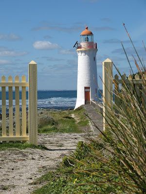
Hikers will be pleased to hear there are two cafes along this coastline, which is not bad for a four day section. One is at the beach and carpark called Cape Bridgewater, and another at the Cape Nelson lighthouse. Yum yum, no objections to supplementing our hiking rations here. The guys out at Cape Nelson lighthouse were so friendly and welcoming to us, even offering to top up our water supplies. Such a hiker-friendly attitude is so rarely seen!
The campsites were superbly set up. Each of the six campsites we stayed at, and the three we walked through, had a good size shelter with table and bench, picnic table in the open (for the sunny days), water tank, fire pit and toilet. Some were grassy, some had plenty of shade and protection from the elements, some tent pads, and one with a coastal viewing platform. Each of the campsites came equipped with several others hikers, which was good, I quite like that feature. It was good to chat to others hiking the trail, some were walking in the same direction, others the opposite, some for four or so days, some the complete trail. For the seven days on the trail we chased someone around the trail, but failed to ever catch them as they were walking super fast it seemed. From what I have read every campsite is being upgraded with shelter installations like these, certainly even back in Easter only half of these campsites were listed as having shelters.
We stayed at a motel in Portland, cheap at $100 per night. The Admella motel was good, it had a catchy tagline emphasing how cheap it was, it was clean and neat and had been renovated. Once again, a friendly crowd. A local told us that Mac's was good to stay at for trail hikers cheap at $70 a night for the older rooms in the motel behind the main pub. On the main esplanade too just off the trail, good if you are walking in from the south, and close to take-away foodies.
* Due to the GPS unit being inside at the cafe at Cape Nelson, this figure is probably 1km too high ** This is to our motel in Portland, not the Portland trailhead. The following day we walked back from the motel to the trailhead. These three things are not corrected for in the above mileage figures. The Google Map and GPS file downloads are corrected.
The Glenelg River in Victoria is gorgeous, a wide river meandering it's way through a gorge, limestone cliffs, surrounded by dense eucalypt forest and pine forest - and - barely a building or road in sight. It's here that we spent the Easter, walking the western half of the Great South West Walk.
Great South West Walk, Lower Glenelg National Park and Discovery Bay Conservation Park
I've paddled down the river three times before, I never imagined that dense eucalypt forest also held a walking trail and walker's campsites.
We walked from Moleside Picnic Area down to Murrells walk-in campsite, up, down, and along the meandering trail. The following day we pushed out the kilometres to reach Simsons walk-in campsite - not quite the isolated campsite that Moleside was, this one is only three kilometres from Nelson. People wandered past walking their dogs, a few 4WDs drove past on the dirt track. Dissapointingly - because I thought I had seen this campsite whilst paddling down the river before - there was no river view for this campsite.
The following day we divided into two groups, Graham and myself pushing out along the beach - after a stopover at the Nelson General Store - to Mo M Beong Lake campsite (also spent Mombeong, or Monibeong). Steve and Krystyna took a more leisurely pace, camping at a campsite midway along the beach. The beach walking was long but beautiful. The guidebook described the sand as "pleasurably hard" which sounds somewhat erotic - I can assure you it wasnt, erotic that is. We took the inland route into Mo M Beong Lake and the campsite, we really enjoyed that route and coming up to the lake. A swim was prevented by the lack of appropriate underwear or all the other car campers around (ok so that hiking underwear went in the bin after this walk).
We made the fourth day our final. We sat eating lunch at Swan Lake campsite, beside the lake, well we think, the location of the actual hike-in campsite was ambiguous, certainly of the campsites we had seen this one had the poorest facilities - all the others we had seen were very good. The nearby car based campsite and surrounding sand dunes were trashed by the tyres of dune buggies. Never have I seen this kinda of wanton damage to a national park from vehicles. We walked on, towards Mt Richmond. We were to camp somewhere ad hoc, to balance the days a little. As we decided to focus on the hours left to walk to the car at Mt Richmond, rather than the kilometres left, we were easily able to make it back to the car by around 4pm, and make that drive into Portland for a pub meal.
Someone asked how it compared with the Great Ocean Walk, well, it may not be a fair comparison. They are different environments. The Great Ocean Road didn't get that name by accident. I love the Glenelg River, but this walk comprises maybe four elements: river; beach; coastal cliffs; forest. In the western half of the trail we did, we walked the river and beach sections. The Great Ocean Walk passes through a more diverse range range of ecosystems, but Great South West Walk is still worth doing, perhaps just not something to rage about. It is much easier walking as the terrain is generally flatter. Despite being on my "To Do List" for a long time, we were only doing this walk now because we couldn't access Wilsons Promontory due to flooding. We met and camped with other walkers, they had intended to do some of the Grampians over Easter, but likewise, couldn't due to flooding. We will get back to finish the eastern half, but being so close to Adelaide I'm not sure when, Christmas maybe (being so close to home it isn't hard to organise a trip there, so I would prefer to use annual leave on trails further away.)
The climb up to Mt Difficult from Troopers Creek is a tough one, but rewarding. The loop around to Briggs Bluff via Long Point is also beautiful - all a very rewarding walk.
Grampians National Park
The 470m climb up to Mt Difficult, is, um, difficult. The trail follows follows the cliff face up. I guess it is a long, steep climb, which is where the difficulty comes in.
We hiked the circuit out to Long Point and around to Briggs Bluff, then back to Mt Difficult, in one day. It was a long weekend, there were many people out, some doing day walks, others camping overnight.
A three day canoe trek down the Glenelg River through the Lower Glenelg National Park with Alex and Bec. Highlight (apart from canoeing down an isolated, natural river) was seeing a platypus.
Friday March 6 to Sunday March 8, 2009 55km, Pines Landing to Nelson, Glenelg River, Victoria
The platypus is notoriously shy. We saw it one morning as we were packing the canoe the kayak. The river was still, dead smooth, and the platypus emerged amidst bubbles about 8-10m from us in front of the landing, before diving down again. "Shhhh!" as I pushed Bec in the back, this was no time for talk. The platypus surfaced twice more for another look around, before disappearing. Btw that's not my photo, I didn't want to loose the magic of the moment by mucking around with a camera, but this photo is the closest to what we saw that I could find on the internet.
We took Friday off work, driving down through Mt Gambier on Thursday night after work. We camped at the beach campsite at Piccaninnie Ponds. Next morning we drove into Nelson, and left our car there as the canoe hire guys drove us out to Pines Landing, from where we would paddle back to Nelson over four days. Pines Landing is where we started this little adventure last time I did it. I was struck by how much this place reminded me of that day four years ago, and of Stephen. From here we paddled 20km to Skipworth Springs, seeing almost no-one. It took a little while to get the canoe technique right, and we each tried out the kayak and canoe to see where we might fare well. The following two days we improved our technique, improving our 5.0km/h average to 5.5km/h. We paddled hard, only stopping to rest at landings, and not, as previously, at random spots to drift. I think was because this time we had the benefit of the GPS unit, so were able to estimate how much longer we needed to keep up the paddling before the next landing. Friday was planned to be our longest day, at 20km, with Saturday to be 14km, Sunday 7km and Monday 14km. We had booked the campsites late, not knowing it was also a long weekend in Victoria. So the short 7km day was unavoidable. But on Sunday, we reached our planned campsite at Bowds, 14km downstream. Since it was only 3pm, we decided to paddle the additional 7km to Lasletts, where we had planned to stay Sunday night. Even though we were only staying at canoe campsites, where space was more limited than the car-based campsites, it seemed likely there would still be space for our two small hiking tents.
Friday night we spent at Skipworth Springs, and had it all to ourselves. Small tents are an advantage at this campsite, as the sites are small since the campground is on a hill. Like all the campsites, there is a toilet, picnic table and at least one fire place. These facilities aren't always marked on the official map, not sure why. There is also rainwater available, except here where there is a natural spring. We hunted down some dry wood, from some dead fallen and not so fallen trees, for a campfire. Victoria is different than South Australia in that fires are permitted during the Fire Danger Season (except on days of total fire ban) and collection of firewood in a national park is permitted. We were visited by the ever fearless possums, who came to our picnic table to clean up our crumbs. For a few moments it looked like we might have a stand-off between two possums, but they resolved their differences and chased each other up a nearby tree.
Saturday night we camped at Lasletts, this time sharing the campsite with a group of eleven and a group of five. So we didn't get in on either of the fire places, but then we didn't actually have a booking for this campsite anyway. Bec's idea of bringing along a picnic rug, as we chairs were too cumbersome, was a real winner. We set up camp in the corner of the campsite, looking over the river and cliffs. These were the same cliffs that us boys had scaled last time to walk into Nelson to collect Julie's car so she could go home for work a day earlier than the rest of us.
We decided a swim was in order here, yet Alex stated he was off to test the water first. "What? Test the water? Whatever dude." You see, you just don't do that. You decide to swim, if it's nice then that's just a bonus. So Bec and I chatted, and a few moments later Alex emerged soaking wet. I was shocked, he was totally wet. He was surprised as neither of us had heard him bomb it in off the landing. Alex and I returned to the landing where I ran off the end. It was cool, but not freezing, and we both avoided touching the bottom. That night we used my little gas lantern I had found by chance on Friday. I car-camping size gas light with a 2-3kg gas bottle was too big to bring, but this tiny one fitted onto a 300g hiking gas canister, and was much better than a torch.
Now I include a random jaws video, it seemed it wasn't only platypus that occupied the waters of this river.
Australia being in drought, we weren't sure what to expect with the water level. We were surprised when we arrived in Nelson on Friday morning to find the river high, indeed, very close to some riverbank buildings. The canoe guy told us the river mouth had silted up just a few days previously, so the river wasn't flowing and was backfilling. At Skipworth Springs, the water level was a mere 10cm from the landing deck. Sunday lunchtime we had trouble finding Forest Camp North, another canoe only campsite. The shorter canoe camp landings can be harder to find, as they are simpler structures than the higher car-camping landings and boat ramps. This particular one even more so, the landing deck being about 10cm below the water surface. Last time we were here, I recall Julie rolling around in the mud beside the landing. Throughout the canoe trek we found a few other landings beneath the water surface.
Monday we paddled the last 14km into Nelson. We stopped at a cliff near Princess Margaret Rose Caves, and climbed part of the cliff to a cave entrance. It turned out this is part of the Princess Margaret Rose Caves network, but has been separated from it by cave-ins. At the main caves landing, we walked up to the shop to grab a cool drink and some food. We hunted around for a while to find a water tank that wasn't contaminated with too much eucalyptus, as Lasletts had also been contaminated.
I recall the stretch from the caves into Nelson as being particularly long and boring, there are not many landings to break up the day. Despite the head wind along Taylors Straight, which slowed us considerably down from 6-7km/h to just 4km/h, bringing our moving average down to 5.2km/h.
Back in Nelson a day early, I took Alex and Bec on their first tour of Mt Gambier's lakes and sink holes, before we returned to Piccaninnie Ponds to camp. We had the campsite to ourselves this time, or so we first thought, before the late night disturbances began. The pubs/nightclubs of Mt Gambier must have closed around 12-1am, as after that until dawn the car park near the beach was hoon central.
After a quick swim in Piccaninnie Ponds on Monday morning - well it was cold and Alex was a poopy head and didn't want to come for a swim so it's a pretty short one - and some yummy pancakes with Nutella, we returned to Adelaide. We stopped off at Bool Lagoon for a look-in, perhaps we could return here and camp for a weekend and do some bird watching, but despite the apparently recent photo on the RAA map, the lagoon was dry with no surface water. We wondered if it might fill a little in winter?
Download kml file to view in Google Earth or adapt to use as a navigational aid in a GPS unit
Nelson Boat and Canoe Hire Chris and Cheryl (08) 8738 4048 www.nelsonboatandcanoehire.com.au The canoe hire was $45 per day, and the kayak $40 per day, with a $40 drop off fee to Pines Landing - total cost $295. My car was securely stored in Nelson.
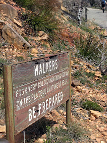
Walkers: fog and very cold conditions occur on the plateau anytime of year. Be prepared.
ABW Grampians trip - Major Mitchell Plateau
Translation, cos really, I've never seen a sign like this before whilst hiking, basically Plateau Subject to Alpine Conditions. Really? Yup. An unprotected windswept high plateau can be pretty bloody cold. But, Major Mitchell Plateau was on it's best behavior. Sunny days which seemed warm, despite the vapour coming from our mouths (turned out it was 9 degrees on Saturday during our plateau ascent). Simon declared it was the coldest he had ever slept (that's a big call for him), turned out it was 0.2 degrees overnight, one of his water bottles froze. But there was no wind, so really, the weather was perfect, indeed on our descent it turned windier (very very cold wind) and Monday morning it rained, as we were on the bus leaving the Grampians the plateau was shrouded in dense fog.
Amazing views. Excellent camping, so weird to camp next to flowing creeks. So much water. The Grampians and me are gonna make good friends.
A rail trail follows a former railway, so the track is always reasonably flat or has slight inclines or declines. And there's the trap for newcomers, ride the slight decline for 28km - barely even noticing the decline, then turn around and ride back - uphill all the way.
Old Beechy Rail Trail, the Otways, Victoria
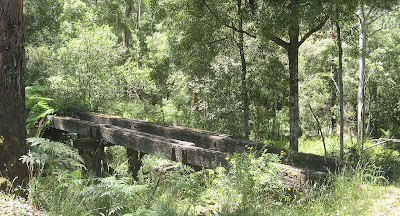
Remants of an old timber bridge
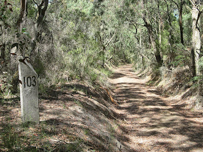
I spent two days whilst travelling along the Great Ocean Road in the cool shady forest. It was high 30's out there in the sun, but very cool riding in the forest. On the first day, I left my car in Colac and rode from the start of the rail trail, at the railway station, to Gelibrand, which is approximately half way along the track. It is uphill riding to Barongarook, which to be honest was quite tough. All of this section is along roads and not along the original railway alignment (the former railway did start in Colac, and the rail trail follows roads adjacent to the former railway). It was a very hot day to be out in the sun riding uphill on dirt roads, but after lots of rests and puffs of my ventolin, I made it to the start of the former railway just beyond Barongarook. Here the riding became very easy, being a steady decline to Gelibrand, with just a few off-the-former-railway-alignment sections. If I rode this trail again, I would start beyond Barongarook, the railway alignment starts at the 103 mile railway marker on Maggios Road. Part of the rail trail, just before Barongarook is on a bitumen road for several kilometres, could be a bit scary for the kiddies.
103 mile marker
Gelibrand was a welcome sight, enjoyed a nice lunch on the verandah of the general store. The ride home was quite a bit more difficult, mainly because it is uphill, and I didn't realise just how easy I had it riding downhill from Barongarook to Gelibrand. It's just that the incline is unrelenting, but you can see in the stats below that although it took me the same time to ride, I didn't need to rest for as long. I put that down to the uphill section being in the shady forest rather than the open sun, and being high on ventolin. The ridge from Barongarook downhill to Colac was easy.
The following day, having learnt something from the previous day, I left my car in Gelibrand. Gelibrand lies at the bottom of the valley, with the Colac at one end of the rail trail, and Beech Forest at the other end, both being at the tops of the ranges either side of Gelibrand.
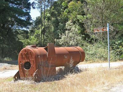
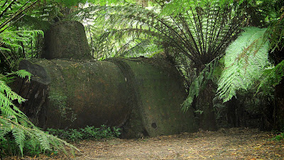
Old steam locomotive boiler at Dinmont
So I rode uphill towards to Beech Forest. I enjoyed this day much more than the first day, it was easier, and I was mentally prepared for it this time. The forest seemed much nicer, lots more bends, and much more riding along the former railway alignment rather than dirt roads. I stopped at Dinmont though, rather than the end of the rail trail at Beech Forest. From Dinmont to Beech Forest is entirely on dirt roads, so I didn't really see the point. No shops at Dinmont either, just a pub. I think future plans for the trail include the rail trail following the former railway from Dinmont to Beech Forest, and perhaps an extension to Lavers Hill and Crowes where the former railway terminated.
The ride back from Dinmont to Gelibrand was a lot quicker than the ride there. I did however fall for one trap... riding uphill from Gelibrand I came across a fallen tree which blocked the path. Trees in forests can be a bit difficult to move, I looked at trying to move it, but a chainsaw would really be needed. So anyway, you'd think I would remember it was there when I was riding back along that way later - because this time I would be riding much faster, being a long downhill run. I've got to say, in the dappled light of a forest, it is very difficult to see a single fallen log across the path when you are riding fast. I had to jump off my fast moving bike to save myself, and somehow I managed to get off and not take a tumble, although my bike got some damage from hitting the log and ground at such speed. It all happened slow enough though, as accidents do, for me to recall the log and realise how stupid I was. So I tried to mark the log a bit, to draw attention to it, but really, is there anyone else out there as stupid as me?
Old steam locomotive boiler near Triplet Falls
When I finished the ride, I enjoyed lunch again at the Gelibrand general store, and spent the afternoon wandering around some local sights - via car this time - like the town of Beech Forest and Triplet Falls. At Triplet Falls there was an old steam locomotive boiler hidden in the forest, amazing to think that all this area was completely cleared by the over-zealous settlers thanks to the railway, and that now you would have no idea that the land had been completely cleared at the start of last century.
I visited the Otway Fly, meh, it wasn't so great. $20 to get in, so not worth it. Although on the way out a couple of backpackers approached me for some tips as to how to avoid the entrance fee, ie in which direction to head to climb the fence. So I guess if they were successful it wasn't quite so expensive on a per-person basis.
Visit official Old Beechy Rail Trail webpage and download map and brochure.
I've completed Victoria's Great Ocean Walk, which follows the coastline near the Great Ocean Road from Apollo Bay to just beyond Princetown.
It's a 91km hike, suggested as a 7-night, 8-day hike. I did it over 4-nights and 5-days, combining 2 suggested hiking days at the start, and 2 at the end.
It was an amazing hike, I camped in the hike-in campsites - some very special places. Lots of coastal scenery, some quite dramatic, and also the forests of the Otways and coastal heaths, and yes a little, just a little, bit of farmland. I highly recommend the trail to those interested in multi-day hikes or trekking, or those who just want to pick out some of the best day hikes. Spectacular stuff.
The blog entries for my 5 days appear below, in reverse order, having been typed up from hand-written entries I made each night (start with Day 1: Apollo Bay to Blanket Bay). They are presented here largely unedited which shows my hopes for the following day, and then you get to witness those hopes shattered. No sorry, probably being a bit dramatic.
For those of you who are impatient or just otherwise uninterested, above in this blog entry I have included the 12 very best photos here. Also find the Google Map (suggest view in full-screen mode).
Driving down to Princetown from Adelaide on Saturday, I took this one rather good photo at Port Fairy. Nice place, lots of old colonial buildings, nice holiday spot one day.
It was a photo that I saw last year of an anchor from a shipwreck on Wreck Beach that inspired me to do this trail. Today I reached the Great Ocean Walk's iconic Wreck Beach.
Day 5: Ryans Den to Princetown
Rated 'hard', the hike from Ryans Den to Moonlight Head continues along the steep hills and high sea cliffs. Rated 'easy', the hike from Moonlight Head to The Gables Lookout heads inland along country roads, through Blue Gums and farmland. Rated as 'medium', the hike along Wreck Beach to the Devils Kitchen hike-in campsite passes the anchors of shipwrecks before climbing to the campsite. Rated as 'easy', the hike to Princetown follows an old coach road, a 4WD track through heathland and coastal scrub with fucking farms views to the north (ok I inserted the fuck bit).
It rained hard last night, after I had come down from sitting on the grassy knoll looking over where I had hiked over the past two and half days. I took a nap, and heavy rains and a thunderstorm came over. Ryan's Den is a bit scary for that, quite isolated, and high on a headland. Thankfully, as with all the hike-in campsites, the tent sites are sheltered from the wind. I cooked dinner in the shelter - they are so good when it rains - with the families I have seen at the last two hike-in campsites I have stayed at. Turns out they work in Search & Rescue, nice to know they were following me each day and staying in the same campsites!
I set out early for my final day's hiking. I had booked to stay in Devils Kitchen hike-in campsite, but had decided it would be easy to hike the extra 7.7km beyond that to my car in Princetown - then I could enjoy a nice cold beer, a shower and a change of clothes, preferably in that order.
Hiking from Ryans Den to Moonlight Head was difficult, it was rated as hard, only the end of yesterday and this section amongst the whole trail was rated as hard. It was, perhaps it was in my head too. Having finally reached Moonlight Head, it was a pretty tedious hike to Wreck Beach through farmland along roads. I really don't like doing farmlands, thanks to the Heysen Trail, but it should be noted this is only the second day I have really seen any farmland and it is fairly minimal.
Climbing down the 350 steps onto Wreck Beach, I met up with some of the fellow hikers from the family I camped with the night before. A few had hiked for the first 3-4 days, until car access was no longer possible.
Wreck Beach was incredible, I got there about an hour after low tide, but I still found myself having to make some made dashes to avoid the waves. Would be a nasty place at high tide. It was a no-brainer that I wanted to go there, so I was pleased the tides were going to work out for me.
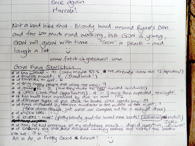
Ascending from Wreck Beach I had lunch at Devil's Kitchen hike-in campsite, where I would have stayed. I wrote a little note in the campsite logbook there.
Another hiker's logbook entry
The hike from there to Princetown was so boring, rated as easy, following an old coach road along the sand dunes. A long, straight sandy track. If it wasn't for the sound of the sea on one side, it didn't matter which direction one turned it all looked the same. I can't say I hiked this section, I trudged it. Knowing that the section from Princetown to Glenample Homestead - the end of the Great Ocean Walk - followed this same sandy coach road confirmed I wasn't going to tackle the remaining 6km tomorrow. Bugger that! Later, as I drove to Port Campbell to stay the night, I noticed that the trail ends at an information shelter beside the Great Ocean Road, the Glenample Homestead is no longer open to the public and the signs pointing it out have all been removed. What an anticlimax that would have been! I'm not sure why the trail doesn't end at the Twelve Apostles, they are only 3-4 km westwards beyond this point.
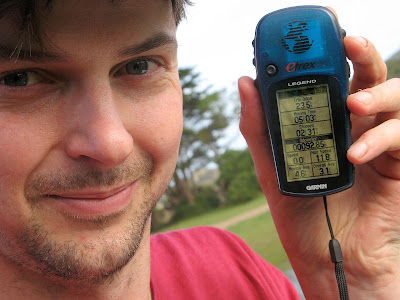
Despite finishing 6km prior to the end of the trail, I still hiked a total distance of 92.86km, so I was pleased I had hiked beyond the 91km figure the trail is meant to measure.
92.86km
True to form, no, don't roll your eyes, my pack got heavier and heavier as I walked along the sandy track closer and closer to my car. But the sight of my car - such relief!
Showering later, I discovered a huge bruise and swelling on my ankle. Well that explained the pain I had been experiencing for the last day and a half - didn't realise it looked so dramatic though.
A butterfly just landed at my feet - and it stayed long enough for me to get a photo. That proves beyond doubt that this place is magical.
Day 4: Johanna Beach to Ryans Den
Rated 'medium', the hike to Milanesia Beach features lush valley views and country roads through farmland and forest. Rated as 'hard', the hike through to Ryans Den starts on the beach the climbs steeply to the clifftops with sensational views, continuing through steep hills and coastal forests passing high sea cliffs.
I'm sitting in a grassy clearing, atop what can only be described as a huge, remarkable headland jutting out into the ocean. From my vantage point, I can see the beach were I had lunch today and the pine forest I walked through on the lands far above it. I can also see the campsite and beach at Johanna where I spent last night. Beyond that, I can see the outlet of Aire River - where I camped two nights ago. And in the hazy distance, quite distinctly, I can see Cape Otway Lighthouse, which I passed on my second day.
I'm on one of the two grassy clearings at the headland just metres from the Ryans Den hike-in campsite. Not only is this place magical - the views from my tent are amazing - but so too is the hike in from Milanesia Beach. It was a tough hike, the hardest section of the Great Ocean Walk - but this added to the magic. It was very isolated and the gullies seemed almost surreal - green moss covered rocks forming slab bridges and steps, all in the midst of an eeriely quite wet forest. All the time, the distinct headland of Ryans Den loomed far out in the ocean, it's shape like something out of a fantasy movie. The enchantment continued when I came upon a staircase that spiralled seemingly endlesslt upwards towards the campsite.
I left Johanna this morning a bit flat and tired. The wind had beem strong through the night, and the wind was unrelenting. THere was no sight og the sun as I hiked along an old coach road that winded through farmland. The rain came in fast and heavy, but eventually cleared. This part of the hike through farmland reminded me, perhaps a little too much, of the many farmland sections the Heysen Trail passes through. It was then I realised that I have a confession to make to you regular End-to-Enders on the Heysen Trail. It's quite a serious confession for a End-to-End hiker... no highlighter have been in my hand, or on my maps for this whole trek!
The farmland eventually gave way to pine forest, following what I think is the first car accessible road on the Great Ocean Walk. It then entered natural bush, thankfully, before descending to Milanesia Beach. In a stream that entered the sea here - finally - I had a refreshing wash. A swim would have been better, no doubt at all, but that sea had looked scary for days, and it was cooler now, and the sun not constant.
Tomorrow I will hike it home, along the Great Ocean Walk's iconic Wreck Beach, past my pre-booked hike-in campsite at Devils Kitchen back to my car - a beer, hot shower, a pub meal and a powered tent site. Perhaps Friday arvo I will complete the remaining 6km from Princetown to the Twelve Apostles.
I think the 21k pack - although I'm sure it's much heavier than that - is too heavy for me. They say you can carry 25% of your body weight, thats 18kg for me - you do the math. It get heavier - I'm serious now - the closer one gets to the campsite, or a landmark location or feature you have been striving for. Don't look at me like that - have you overnight hiked before with a 20kg+ pack? Can you disprove me? I think not. So yeah, like I was saying, it gets heavier. That's a given. Conversely, first thing in the morning, it's much lighter - if you keep pulling faces like that I won't go on, I can lip read to you know, you potty mouth. The pack was definately the heaviest for the first 2km along the road from Apollo Bay. Evidently something rather heavy fell out after that point, although I can't seem to account for what was lost - oh for goodness sake stop rolling your eyes.
My shoulders and hips seemed quite bruised the first day - but not since. My feet are pretty sore at night - definately sorer than anything else. But the single-use hand warmers work a treat inside my socks next to my toes - insert product promo here. They are small sachets with iron and salt in them I think, you shake one and minutes later it is toasty warm. It says it will last up to six hours, but lasts more like twenty-four hours.
Overall though I'm not too sore, the body really does adapt to this multi-day hiking much better than just to one or two days of hiking. As I type up my hand-written notes now, on Friday, I can say I feel really stiff now. How did my body suddenly become stiff after five days of hiking, when I have finished, on the sixth day, and not on the fifth day when I was still hiking? Clever stuff those bodies.
I've only had one blister, on my heel. But a blister pack and some sports tape is keeping that in check, a pretty minor blister. Unthinkable of course to those of you that know me, that I would hike without my lamb's wool on my heels, works a treat to prevent the inevitable hot-spot blisters I get. This product is so cheap and simple, forget the fancy blister products, this wool shits all over them. Thanks Leonie, I was a slow on the uptake in believing and trusting in them, but now, nothing else for me!
My hiking boots are working a treat - so glad I didn't opt for my hiking shoes like I wanted to. Lots of mud and creek and sea rock platform crossings, and lots of sand from beaches and sandy tracks to fall into lower ankled footwear.
My knees are tops, thanks for asking - OMG, how '80s is 'tops' - no pain to report. Perhaps largely in thanks to the trekking poles that have never left my side, not even my arms are hurting from them. The trekking poles an absolute must for carrying a 21kg pack, otherwise I only ever use one when I hurt a knee.
Btw, the transfer service I used (highly recommended) is as follows:
GOR Shuttle
Cape Otway
Providing a personalised 4WD pick-up and drop-off service to and from your choice of accommodation along the Great Ocean Walk
Ph: (03) 52 379 278 / 0428 379 278
email: gorshuttle@bordernet.com.au
Food drops
Backpack forwarding
Car shuffling for clubs, larger groups
Bicycle forwarding
Local knowledge and experience with all credentials
Tours: Maits Rest, Otway Fly, Triplet Falls, 12 Apostles, Loch Ard Gorge etc or tailormade tour
I love nothing more then experiencing life outdoors by man power - hiking, cycling and paddling. Camping along the way in remote and beautiful locations.
And I like the share what I find, so enjoy! Most trips have maps and track notes with them, and GPS files for downloading onto a handheld GPS unit (GPX files) or viewing in Google Earth (KML files).


