Showing posts with label day hike. Show all posts

Monday, May 20, 2013

Mt Woodroffe, #7 of the State 8

Is it OCD? That sees a list of the eight highest peaks in Australia's states and territories and then wants to tick them all off? Maybe. This one, Mt Woodroffe - South Australia's highest peak - was my number seven, of eight, the so-called State 8, or Aussie 8. Apparently I'm not alone in my affliction, there were 28 other people booked onto this tour.
SUMMARY - Mt Woodroffe climb/hike
Duration1 day hike (3 day trip)
Start/endNgarutjara (3 day trip to/from Uluru)
FridayDrive from Yulara, Uluru, to Ngarutjara camp (base of mountain)
SaturdayHike up Mt Woodroofe (Ngarutjaranya) 1435m
SundayDrive from Ngarutjara camp (base of mountain) back to Yulara, Uluru
AreaAPY Lands (permit required)
BookingsDiverse Travel Australia, SEIT Outback Australia
Topographic Maps1:250 000 Mt Woodroffe SG52-12: printed map, on-demand 1:100 000 print, free download (official map)

The only way to access Mt Woodroffe, in the remote APY Lands in northern SA, was via a tour group. Once a year they run a trip in, and it's the only one with permission from the Traditional Aboriginal Owners to do so. It's also rare for them to give anyone else permission, so the tour is the most practical way to do it. It makes Mt Woodroffe the most difficult of the State 8 to organise.

With the permission in mind, at our camp on the first night near the foot of the mountain, we were visited by Lee, one of the Custodians. As can happen in these situations, we took him all a bit too seriously, almost missing his first joke and his fine sense of humour.

When he first sat by the fire, he took his shoe off to warm his foot, complaining about the severe pain in his foot that a heel spur was giving him. Of course we doubted - I can hear your mocking cries now - that he would make it to the top of Mt Woodroffe. We were equipped with all our expensive hiking gear, when he looked more like he had come from fixing a car (he had, as it turned out). Of course, how wrong we were, it was Lee who led the charge up the first steep waterfall rockface. Few followed up the waterfall though, preferring to pick an easier route over a gung-ho approach. There was no doubt that Lee got into as much mischief now as he did when he was a ten year old boy.

Later Lee's father, aged 82, arrived. It quickly became apparent that he would talk in exchange of cups of tea, and if the tea disappeared so would he. He talked with a hint of humour in his slow words. He'd only been learning English in the last 10 years, evidently taught by the many school girls that came out here on school trips (SEIT tours core business is ten-day school Aboriginal cultural camps, this being one the campsites they use for that). I'm not sure how much that skewed his vocabulary, but in exchange he would teach them his language.


On our first day, after arriving at camp, we were taught how to not use the supplied swag, and a discussion ensued about the wisdom of camping in the creek bed, with it soft sand and shade. Normally, of course, this is a poor decision - to camp in a creekbed - but when you can see the headwaters, just a mere 7km away up the mountain, it's pretty safe to camp, even in a wide creek. I've done it before when the headwaters can be seen. If it rains, and especially if it rains a lot, then it's time to move. Pretty hard to miss rain in a swag.

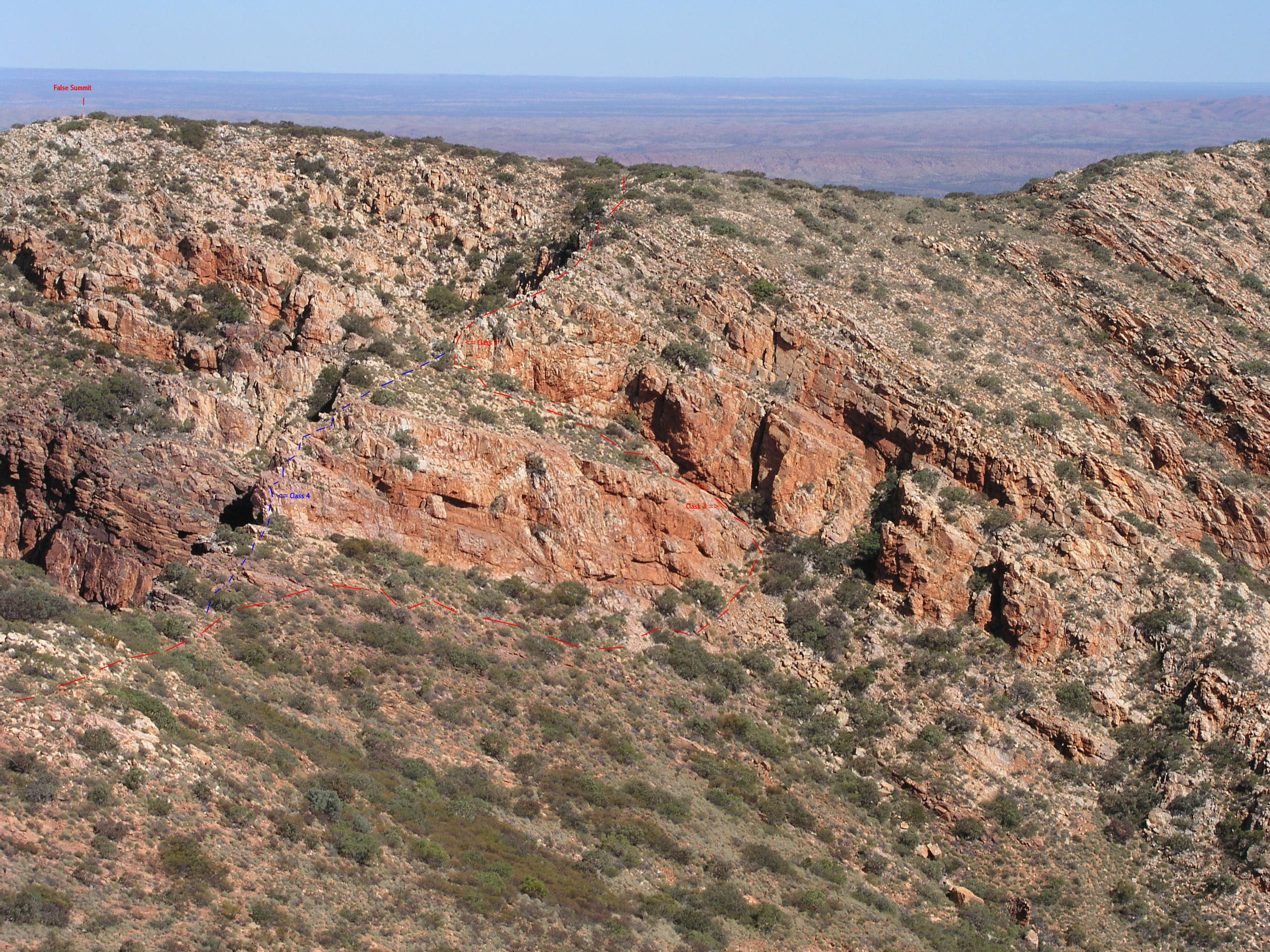
We drove over to the foot of the mountain, to assess routes to hike and climb up the following day. Being a rogainer, I was already formulating a few options into plans, and on the drive closer was able to clarify some of them. At the foot, with most of the mountain obscured behind the immediate base, advice was given as to the easiest routes, and as to where the harshest spinifex lay.

Before dawn the following day, we drove back to the base and at first light set out. It was a case of each to their own, or better still, in small groups. A few set out directly from the cars with a short but sweet route, a straight up the mountain. It was a route plotted through the harshest spinifex, but nonetheless a sound route. Most others followed Lee to the waterfall rockface, before quickly dispersing by a variety of routes. For a while there it looked like we would find about 29 different routes up the mountain. I took a gentle route around the waterfall, taking my plotted course up to the ridge in the east, before hiking up the long spur to the summit. It was the easier route, relatively free of spinifex, and easy to navigate. Although I got to the top first, even having taken the longest route, I had hiked alone, and no doubt that allowed for some speed. It was just seven minutes later that the next group arrived, having taken the most direct route up from the cars.

For all my efficiency and speed in getting to the top quickly and with minimal spinifex injuries, I must have banged my head on the way down - maybe I should wear a safety helmet on such climbs - for I momentarily lost my mind. I decided against taking the three additional people now hiking with me along the long distance ridge, and decided on a shortcut down. Ricky, perhaps sensibly, decided to hike on along the ridge to the western end and it's unnamed summit. It wasn't long down our shortcut that it became obvious - this was no shortcut, and indeed, it took us longer to complete then the distant route. Thankfully I brought those three companions to share the misery of my foolishness. Ricky, having completed his second peak climb, caught up with us near the base. So much for our shortcut. Encouragingly, it seemed that everyone was slower on the trip down, compared to their trip up.

The view from the top took in distant Uluru and Kata Tjuta, some 130km away across the NT border. The Musgrave Ranges spread out to the east and west, a mess of scraggly mountains. Many South Australians don't know what lies up here, thinking that St Mary Peak in the Flinders Ranges, on the Wilpena Pound rim, is the highest peak in South Australia. It's not. Here in the Musgrave Ranges lie 21 mountains over 1,000 metres, and the top seven mountains of the State. St Mary Peak comes in as the 8th highest. Mt Woodroffe rises 680 metres above the surrounding plains.

An old stone surveyor's cairn marks the top of the mountain. A famous photo, taken in 1933, with three Pitjantjatjara guides, shows how the cairn originally appeared. The mountain was named after George Woodroffe Goyder, the 1857 South Australian Surveyor General highly regarded - at least now anyway - for his work in establishing what became known as Goyders Line, the line across the state that marks arable farming land from that which is not sustainable farming land. He was mocked at the time, but hey, at least there's the odd thing around the state named in his honour.

My skills in the exploration of the stone cairn fell well short of my skills displayed in getting up the mountain, and it was someone else who found the logbook in a rusted old can buried deep in the stone cairn. The word 'logbook' is a somewhat generous description, it was almost entirely a collection of rotten indecipherable paper fragments, with the odd modern addition of single pieces of paper. Why some people feel the need to describe the 'marvelous' or 'spectacular view' they saw is beyond me, it's really quite self evident to others who have managed to get there to read the logbook. Anyone with the misfortune of climbing in poor weather, which really is misfortune in Central Australia's stable weather, would hardly find enlightenment with the description of the view in the few moments they spent huddled on the leeward side of the stone cairn before heading back down.

With 29 people on our tour, every one of them made it to the top of Mt Woodroffe that day. Whilst it's cliched to say "there's one in every crowd", it was nonetheless true. If there is one thing more fun than 29 people on a tour, it's this: 29 people offering advice to the one person who is scruffing around in the red dust under the vehicle with a car jack replacing a blown tyre. That wasn't quite true, we had two vans and a ute for the tour, so whilst there were plenty offering advice, it wasn't quite as bad as 29 people. It was a big tour group, I had been warned when I booked that if the tour didn't reach the minimum of four people, it would be cancelled. Last year it was cancelled, with just two bookings.

So in my State 8 pursuit I've been all around the country and found many hiking places to return to. My first peak, Mt Ossa, in Tasmania was mostly accidental, a side trip on the Overland Track. I almost gave up climbing it too, if it hadn't been for Tim's enthusiasm. Now five years later, only one remains. A crazy plan is in place to complete it - Queensland's Bartle Frere. We shall see my friend, we shall see.


View photo album in Google Plus (9 photos).

More photos to come


View in full screen format
Download GPX file of the Mt Woodroffe summit climb hike - for use as a navigational aid in a GPS unit
Download KML file of the Mt Woodroffe summit climb hike - view in Google Earth

My State 8 (Aussie 8)

The highest peak in each Australian state and territory:
  1. Mt Kosciuszko, New South Wales (NSW), 2228m, March 2012
  2. Mt Bogong, Victoria (VIC), 1985m, March 2012
  3. Bimberi Peak, Australian Capital Territory (ACT), 1913m, March 2012
  4. Bartle Frere, Queensland (QLD), 1622m, NOT YET DONE, June 2013?
  5. Mt Ossa, Tasmania (TAS), 1617m, December 2008
  6. Mt Zeil, Northern Territory (NT), 1531m, July 2012 (first attempt August 2011)
  7. Mt Woodroffe, South Australia (SA), 1435m, May 2013
  8. Mt Meharry, Western Australia (WA), 1252m, June 2010

Wednesday, September 5, 2012

25 hours hiking? Why not!

A 25-hour hiking race? Why not! We'd done a 12-hour and 6-hour rogaine, so now a 25-hour challenge. Rogaining is a team sport which involves cross country navigation and strategy. This time it was up in the forest and scrub of Wirrabara and Kate joined our team, bringing along her navigation prowess.
Rogaine, Wirrabara Forest


Our route marked with a red line (we travelled clockwise).
View larger map
While studying the map and planning our route in the hours before the rogaine, I made the comment that the scrub near the ridge line was, from memory, pretty thick. A big bushfire had burnt through much of the area in May, so we were hoping this would have cleared some of the dense ridge. It had, leaving a loose, sandy and rocky surface that was still hard to climb. Not all was clear though, through the untouched native scrub we managed about 1km/h, and gained lots of scratches for our efforts. We were pretty relieved when we finally made the ridge with its road!

On our way through the scrub, we spied a girl waiting on a distant hill, apparently for the rest of her team. But not so, over the other side some ten minutes later, we found a single person – this is a team sport btw – asking whether we might have seen a girl in a blue top! We had of course, but on the other side of the hill. A wee bit silly that they got separated, we met up with them later that night and they had spent an hour and a half finding each other.

We tackled the higher ridge and scrub in the daylight first, returning after dark via the lower forest with its gentle hills, open forest and easy to navigate service tracks.

A couple of the controls (point markers) were over the other side of the ridge, which meant climbing back up to the ridge again afterwards. That was a bit tough! At one control, number 71, we spent some time discussing where we thought we were, and each of our interpretations of the topographic map. Down we went, but we certainly weren’t coming back up the same way, pleasantly open that it was, we skirted across the side of the ridge to another track.

Seven hours into the rogaine we watched the sun set from the ridgeline, exchanging tips with teams coming the other way.

In the darkness we descended off the ridge and back into the forest, armed with our head torches of various brightnesses, and the full moon. At the furthest point from the Hash House – the base of the rogaine – we sat down at a picnic table on the summit of Mt Ellen and had a moonlit picnic. From here we trundled back to the Hash House, thinking of the enormity of our plan which still required a three-hour walk back to the Hash House base when we were dead tired.

At 2am we sat down for some hot food and in front of the warm fire at the Hash House in Wirrabara’s old schoolhouse.

Armed with four hours sleep, and with the warm sun up, we returned to our rogaining. This time we planned a shorter route, with more options to return early - and most of all - an easy walking route. We were back at ten past 11 in the morning, with 50 minutes to spare. We weren’t keen to climb a nearby scrub hill to fill our last 50 minutes, we were all limping in one form or another.

We scored 1760 points, covering 63km, and came 7th overall, and 4th in the mixed category. We spent 15 hours on Saturday, 11am to 2am (49km), and 3 hours out on Sunday morning (14km).

View all results on the SA Rogaining website.

Monday, July 9, 2012

Mt Zeil - NT's highest peak (The State 8)

Last year we'd tried to climb Mt Zeil, but with the summit cairn in sight, had to give up. We had hiked in from Redbank Gorge on a three day hike. This time we had permission from the NT Parks and the local pastoral station.
SUMMARY - Mt Zeil
State 8 Northern Territory's highest peak
Location West MacDonnell Ranges, west of Alice Springs
Access Glen Helen Station and West MacDonnell National Park
PERMISSION REQUIRED Contact both:
  1. Gary Weir,


    Deputy Chief Ranger, West MacDonnell National Park

    Gary.Weir@nt.gov.au

    (08) 8951 8273

    0405 603 152

    Fax (08) 8951 8290
  2. Ian Morton,


    Glen Helen Station - pastoral property (not to be confused with Glen Helen Resort)

    (08) 08 8956 8548

    or (08) 8952 3063
Maps
  1. 1:50 000 topographic Special map - contact Rangers at West MacDonnell National Park to obtain.
  2. 1:250 000 SF53-13 Hermannsburg (this map is not sufficient alone, use in combination with 1:50 000 map available from rangers)
Time 4 hours up
Route Follow long western spur
Start elevation 650m
Peak elevation 1531m

We drove the three hours in from Alice Springs, along the Tanami Track, Gary Junction Road (Papunya Road), then on station tracks through Glen Helen Station to the base of the western spur of Mt Zeil.

With the pre-dawn moon, we hiked across the plains to the base of the spur. As day broke, we climbed up to the plateau some 380 above the plains (at 1070m). There are various routes to choose from to access the grassy plateau. From here we tried following the official route provided by Parks NT, which is to skirt around the ridge peaks. We found this to be tricky: it was harder to navigate, psychologically harder, harder to walk on a constant side incline, and having to dodge obstacles such as patches of rocks or denser vegetation. Soon, we instead followed the ridge, it was much easier. It was easier to navigate, and the ridgeline was clearer of rocks and vegetation.

Reaching the summit in four hours, and whilst filling in the logbook, updated my Facebook status - yes, there was Telstra NextG coverage.

This summitting was my second attempt, I had tried last year to come in from Redbank Gorge as a three day trip, but did not quite reach the summit.

This was part of Ricky, Paul and my State 8 challenge - to hike the highest summit in each of Australia's eight states and territories. For all of us, this was Number Six, although we differ in which ones remain.

Thanks to my traveling companions, Ricky and Paul, and some of their photos are included below.

View photos on Google+.


View in full screen format
PERMISSION IS REQUIRED, and highly recommended, to access and climb this peak. Detailed maps and advice will also be provided when permission is granted.
Download GPX file of Mt Zeil climb - for use as a navigational aid in a GPS unit
Download KML file of Mt Zeil climb - view in Google Earth

Stats

Mt Zeil
Monday
9/7/2012
Up Down
Distance 10.3km 10.1km
Start Time 6.08am 11.52am
End Time 11.04am 3.14pm
Moving Duration 3h17m 2h52m
Total Time 4h47m 3h22m
Moving Average 3.1km/h 3.5km/h
Overall Average 2.1m/h 3.0km/h

Monday, August 29, 2011

Hiking Mt Sonder - the proper true summit

When I first did the Mt Sonder hike back in August last year, when I reached the top I discovered - much to my horror - that the trail lead to a false summit, not the true summit of Mt Sonder. Initially I figured it was for safety reasons, but later people replied to my blog, informing me that the Arrernte People had special beleifs about Rwetyepme (Mt Sonder), and that was the reason the trail did not reach the true summit.

Mount Sonder (proper), West MacDonnell National Park, Northern Territory


At Glen Helen a few days ago, having traipsed across the countryside for three days in search of Mt Zeil, I had flicked through a collection of newspaper articles in the cafe. I stumbled upon one from the Sydney Morning Herald from back in 2005, when a reporter did a story on the Mt Sonder hike. He had fished around, suspicious of the story of the false summit trail. Interviewing a park ranger, James Pratt, "he shattered one illusion when he explained that the supposed Aboriginal legend was 'just an urban myth'. ... He also confirmed that the official summit was not the real one. 'It was a decision made for safety.'" They held beliefs of the mountain, just not the one that is being thrown around, and it was not the reason the trail did not go to the true summit.


Enough said, I was convinced. We were off to reach the real summit. The newspaper article referenced a Norwegian professor, Petter E. Bjorstad (referenced below). He had climbed many mountains around the world, including the true summit of Mt Sonder. He had some track notes, we were set.

At the campsite on the dry sandy banks of Redbank Gorge the night before our hike, we met Jas and Kev, from Parkham in Melbourne. They had just completed 19 days on the Larapinta Trail, hiking out from Alice Springs. The wildfires had chased them down the trail. They had one final section left, the climb up to Mt Sonder. They were keen to reach the true summit. We shared our track notes.

The next we saw of them was when Graham and myself reached the false summit early the following morning. Off on the distant true summit, we could see a couple of silhouetted people wandering around the summit cairn. They were only about 750m away across the rocky cliff-sided saddle, but we could hear their voices. They had risen at 4.30am, so they could enjoy watching the sunrise from the false summit. We didn't care for the early rise and hike in darkness.

Reaching the false summit is easy, a 7.5km track along the rocky spur from Redbank Gorge. Reaching the true summit was another matter. We headed back along the track, down from the false summit cairn, then headed north to the cliff edge. From here we surveyed possible routes down. The Norwegian professor included a photo of possible routes down from the false summit peak to the saddle below. From there crossing the saddle and then climbing the true summit was straight-forward. We were watching Jas and Kev return down the true summit. We thought we might wait it out for their advice since they had just made the crossing. We shouted out our hellos, and they soon shouted back their directions.

We climbed down the steep slope along the rock strata, heading for the top of the steep gully. Halfway down, we met up. They looked maggotted. Truly. The steep gully was tough work, returning later to make the ascent was even tougher. This was the hardest bit of the climb from the false to the true summit. Having reached the bottom, we contoured around to a small saddle at the base of the true summit, then climbed the rock 'staircase' to the true summit.

Jas was right, it was glorious and well worth the hike over. There was more to see, and unlike the view from the false summit, no thumping big mountain in the way of a 360 degree panorama. We could see wide wildfires burning on the western horizon.

We did a few laps of the stone cairn searching out the illusive logbook. We kept up the search, there must be one. Then I caught a glint of plastic, there, buried deep from the top of the cairn was the logbook. Placed there in 1965, in quite a rustic steel container, we found lots of pieces of paper, no book as such.

Leafing through the papers, I was surprised to find none from this century. That's right, not this decade, but this century. Not for a moment do I think we were the first people up there in 12 years, I mean Jas and Kev had been here moments before. I think it was more a matter that the logbook had been lost deep in the cairn for a number of years. I really was eager to find it, you see, I knew there had to be one lurking around somewhere. The Larapinta Trail was opened in 2002, which would have included that trail up to the false summit. The number of people reaching the true summit probably would have dropped around then, but the sheer number of people who reached the true summit in the '90s was proof enough that many people would have been up here since then.


  • Have you hiked up to the true summit of Mt Sonder? What route did you take?
  • Did you find and sign the logbook?
View in full screen format
Download GPX file - for use as a navigational aid in a GPS unit
Download KML file - view in Google Earth


View full hike from Redbank Gorge to Mt Sonder South (the false summit) and onto the true Mt Sonder summit in full screen format
Download full hike in GPX file - for use as a navigational aid in a GPS unit
Download full hike in KML file - view in Google Earth

TRACKNOTES - Mt Sonder

Proceed back down the marked trail some 180 metres from the cairn on the false summit. The ridge is wider, the track having just come off from steep north-south cliffs facing the east. There is a number of small paths leading off the north (GR528901), some no doubt in part to take in the view of Mt Sonder proper. A number of rock stratems lead downwards to the west. 50m to the east there are three pines on the east facing cliff edge mentioned before. Study Petter E. Bjorstad's photo of possible routes, taken from the true Mt Sonder, looking back to the false Mt Sonder summit. It is easy enough to use his red marked route, you can ignore the blue rope-using route. Walking down the steep strata, proceed down the steep gully. Careful, there are lots of loose rocks on the slippery surface, plenty of spinifix and other hostile bushes you will need to be friendly with (they don't really want to be your friends.) The grid reference around this steep gully is 529 903. From the base of the steep gully, contour around to a small saddle at grid reference 533 904. From here, climb the rocky 'staircase' to the true summit. Return by the same path, being careful to pick out the right steep gully to climb. It took us 2.5 hours to hike from the false summit to the true summit, and return again. It is 2km return. I wouldn't tackle this section unless it is in the morning, without a breeze it can be insatiably hot climbing the steep gully with the northern sun.
Stats

Mt Sonder (proper)
Saturday
27/8/2011
Redbank Gorge to Mt Sonder South, then onto Mt Sonder proper
Distance 17.3km
Start Time 6.30am
End Time 12.50pm
Moving Duration 4h26m
Stationary Duration 1h47m
Moving Average 3.9km/h
Overall Average 2.8km/h

Monday, July 11, 2011

Three lil' hikes

Three lil' hikes - with steep hills - led by Simon


Three recent afternoon hikes which Simon led, we enjoyed some sunshine and rain and exploring some of the hills, and, of course, some tough hills.

Sturt Gorge

Sunday 19 June 2011

View in full screen format
Download GPX file - for use as a navigational aid in a GPS unit
Download KML file - view in Google Earth


Cleland Conservation Park

Sunday 26 June 2011
Found a tough new hill.

View in full screen format
Download GPX file - for use as a navigational aid in a GPS unit
Download KML file - view in Google Earth


Gandys Gully

Saturday 11 July 2011

View in full screen format
Download GPX file - for use as a navigational aid in a GPS unit
Download KML file - view in Google Earth

Thursday, March 17, 2011

Julian's tour of Gandys Gully

Another Thursday night, another tour, this time by Julian around Gandys Gully.

Gandys Gully


A gentle but steady climb up to the stone cairn on the summmit near Coach Road, then wander back down the fire track to the other stone cairn and down the hill. We've often done this hike in reverse, doing the steep walking track up to the first peak and cairn, then down the gentle descet in the valley. Again, plenty of blackberries and the odd koala.

View in full screen format
Download GPX file - for use as a navigational aid in a GPS unit
Download KML file - view in Google Earth


Stats

Gandys Gully
Thursday
17/03/2011
Distance 6.17km
Start Time 6.01pm
End Time 7.39pm
Moving Duration 1h38m
Overall Average 4.0km/h

Sunday, March 13, 2011

Hot, hot, hot

The hottest day ever? Well, hiking maybe. It was hot out in the sun and there were plenty of hills. By midday though it came over with full cloud, and a light rain started. Soon the temperature had dropped by eight or nine degrees, oh the relief.

Kersbrook, Mt Crawford Forest


This hike from the Push the Bush book is very good. Apart from a little main bitumen road walking at the start, it is almost entirely in native bushland or plantation forest, with the occasional small dirt road.

We only got a little lost once, and it was easily overcome. We got lost just before Point 3, we were following the creek from the main fire track which we had left at the first valley. After a 200 hundred metres, there was no obvious tributary turning sharp right. Consulting the GPS, we decided to make the short climb up out the valley onto the parallel fire track which we think is where the tributary would have led (if it existed.)

In this same area, on this warm, early Sunday morning, and off of any tracks, we saw small group of hikers battling their way through the undergrowth. It turned out to be Julian and Colin walking with some friends doing a reccie walk for ARPA. So funny to meet them not on a track.

Due to the heat, we didn't do Point 12, we stuck to the main bitumen road back into Kersbrook.

  • Have you walked here before?
  • Have you done any other walks in the Push the Bush book?
View in full screen format
Download GPX file - for use as a navigational aid in a GPS unit
Download KML file - view in Google Earth
Stats

Kersbrook - Push the Bush
Sunday
13/3/2011
Kersbrook loop, Mt Crawford Forest
Distance 23.6km
Start Time 8.36am
End Time 2.37pm
Moving Duration 4h33m
Stationary Duration 1h19m
Moving Average 5.2km/h
Overall Average 4.0km/h

Thursday, March 10, 2011

Chambers Gully

Back to Chambers Gully with the Thursday group. A couple of good hills and bush bashing, some of it made up as we went.

Cleland Conservation Park


View in full screen format
Download GPX file - for use as a navigational aid in a GPS unit
Download KML file - view in Google Earth


Stats

Chambers Gully
Thursday
10/03/2011
Distance 8.01km
Start Time 5.59pm
End Time 7.42pm
Moving Duration 1h35m
Stationary Duration 6m
Moving Average 5.0km/h
Overall Average 4.7km/h

Thursday, February 24, 2011

Gandys Gully

It's been awhile since I have walked with the Thursday evening group, this time it was over to Gandys Gully.

Gandys Gully


Good hiking, lots of tracks I have never been on before, this is an area I have only done a couple of short walks in. Good, steep hills, lots of blackberries in season.

View in full screen format
Download GPX file - for use as a navigational aid in a GPS unit
Download KML file - view in Google Earth


Stats

Gandys Gully
Thursday
24/02/2011
Distance 7.23km
Start Time 5.57pm
End Time 8.01pm
Moving Duration 1h44m
Stationary Duration 19m
Moving Average 4.1km/h
Overall Average 3.5km/h

Sunday, February 20, 2011

Montacute Conservation Park

A short but steep hike, a good test of hills-fitness.

Montacute Conservation Park

Update 2016: You can also view this hike, with photos and a map, on Walking SA's Find a Place to Walk directory.


It's only a month until our next instalment in the Beyond the Heysen trek, eight days hiking from Arkaroola to Mt Hopeless - the northern end of the Flinders Ranges. Good to know the hills are still quick and easy.


This hike is from 50 Real Bushwalks Around Adelaide by the late George Driscoll. It is hike number 42, titled 'ead for the 'ills - for whatever crazy reason.

View in full screen format
Download GPX file - for use as a navigational aid in a GPS unit
Download KML file - view in Google Earth


Stats

Montacute Conservation Park
Sunday
20/02/2011
Distance 6.23km
Start Time 8.35am
End Time 10.07pm
Moving Duration 1h20m
Stationary Duration 8m
Moving Average 4.7km/h
Overall Average 4.2km/h

Sunday, February 6, 2011

Mylor to Aldgate circuit

A great half-day circuit, much of it within reserves, reserves I had no idea existed.

Mylor to Aldgate circuit


I had seen this walk on Everytrail by HeysenBarry. The photos showed a lot of reserve walking, I couldn't quite figure out how, but true enough, after following his GPS trace into a small path off of Stock Road, we were led through a long, peaceful reserve - the Valley of the Bandicoots (and more here) A few other dirt tracks, side roads, and then back along the Heysen Trail to Mylor. A good loop.

View in full screen format
Download GPX file - for use as a navigational aid in a GPS unit
Download KML file - view in Google Earth


Stats

Mylor to Aldgate circuit
Sunday
6/2/2011
Distance 10.9km
Start Time 8.28am
End Time 11.02am
Moving Duration 2h14m
Stationary Duration 10m
Moving Average 4.9km/h
Overall Average 4.5km/h

Sunday, October 17, 2010

Pewsey Vale to Greenock

A catch-up walk with Hilary, she is set to complete the Heysen Trail for a second time next year. We finished the Trail together back in 2008.

Pewsey Vale to Greenock


Today's walk was a sharp contrast to the conditions we did the original walk in back in December of 2007 when it was very hot.

Sorry, no photos or GPS map, stuff was stolen.

Saturday, October 2, 2010

Grampians - Mt Stapylton and Mt Zero

A day walk up to the summit of Mt Stapylton and over to Mt Zero.

Grampians National Park


The track ends just below the summit of Mt Stapylton.

We followed up the day hike by a two day hike up to Mt Difficult and Briggs Bluff.


View in full screen format
Download GPX file - for use as a navigational aid in a GPS unit
Download KML file - view in Google Earth


Stats

Grampians National Park
Saturday
02/10/2010
Mt Stapylton and Mt Zero circuit from Mt Stapylton campground
Distance 16.8km
Start Time 7.14am
End Time 1.29pm
Overall Average 3.0km/h

Sunday, September 26, 2010

Mt Bryan

Just a short wander up to the summit of Mt Bryan, doing some reconnaissance for another hike, so just drove along the roads at each end from Hallett and the old schoolhouse at Mt Bryan East.

Heysen Trail, Mt Bryan


View in full screen format
Download GPX file - for use as a navigational aid in a GPS unit
Download KML file - view in Google Earth


Stats

Mt Bryan
Sunday
26/09/2010
Distance 7.86km
Start Time 9.48am
End Time 12.22pm
Moving Duration 1h49m
Stationary Duration 39m
Moving Average 4.3km/h
Overall Average 3.2km/h

Saturday, September 18, 2010

Blocked by the South Para River

We had planned to cross the South Para River and walk into Hale Conservation Park, but the river was swollen and a little too difficult to get over, especially since we would have to return by the same route later in the day.

Warren Conservation Park


I have crossed the river here before, what a delightful surprise to see it so full of water. We walked up and down the river a little, by now sign of an easy way to cross it.

View in full screen format
Download GPX file - for use as a navigational aid in a GPS unit
Download KML file - view in Google Earth


Stats

Warren Conservation Park
Saturday
18/09/2010
Distance 13.26km
Start Time 8.50am
End Time 1.12pm
Moving Duration 3h05m
Stationary Duration 1h14m
Moving Average 4.3km/h
Overall Average 3.1km/h

Sunday, September 12, 2010

Mt Lofty circuit

A classic walk from Chambers Gully up to Mt Lofty summit, then back down the Pioneer Women's Trail.

Cleland Conservation Park


A good catch-up with Vicki, we spied a group of walkers from the Heysen walking club.

View in full screen format
Download GPX file - for use as a navigational aid in a GPS unit
Download KML file - view in Google Earth


Stats

Mt Lofty circuit
Sunday
12/09/2010
Distance 16.48km
Start Time 8.55am
End Time 2.03pm
Moving Duration 3h24m
Stationary Duration 1h44m
Moving Average 4.8km/h
Overall Average 3.2km/h

Tuesday, August 17, 2010

Uluru - Kata Tjuta National Park

It's an image every Australian has been overexposed to. Uluru. The Rock. I didn't have high expectations, but when I first saw it on the horizon, I was still left breathless. It really is awe insprining.

Uluru - Kata Tjuta National Park, NT


The rock climb. I'd be interested to know, how many Australians who visit the park do the climb. Is it mostly internationals? The climb is not noted on the map amongst the other walks, the distances and times are not mentioned. There is no information on how to access the walk, only a request not to climb it, and safety advice should you wish to, including listing the symptoms of a heart attack.

The national park was created in the 1950s, the land excised from the adjoining Aboriginal reserves created in the early 1920s. In 1983 the federal government agreed to close the climb. In 1985 the park was returned to the local indig people, on the condition the land be leased to the government - to be jointly managed as a national park - and they reneged on the climb - it was to remain open. There is no longer any real discussion as to whether the climb should be open or not, it now a matter of when it will be permanently closed. Last year, in a draft of the next 10 year management plan, it was recommended that the climb should be permanently closed.

Uluru or Ayers Rock? Well, since dual naming was officially adopted in Australia in 1993, either, both. So in December 1993 Ayers Rock was renamed Ayers Rock / Uluru. Then, in 2002, the order was reversed, Uluru / Ayers Rock. Most Australians though simply refer to it as Uluru. The road signs are a real mixture, near Alice, Uluru or the dual name. Closer to the rock, they revert to using Ayers Rock. In the national park, exclusively Uluru.

Then there is Yulara, the town created in 1984 some 20 kilometres from the rock. When it opened, all the existing motels, airstrip and other buildings at the base of the rock were demolished and the land remediated. The road signs point to Yulara, but when you get there, you are left wondering if you are about to turn off into the town or not. There is no mention of the Yulara name, it is called Ayers Rock Resort. The town was created by the NT government - hotels, motels, caravan park, supermarket, all the hallmarks of a designer town. When the town in it's enterity was divested of by the government to a private company in 1997, that company adpoted the name Ayers Rock Resort. No Uluru, no Yulara.

Modelling the socks and sandals look, my feet were too injured for those hiking boots, I hiked the short circuits of Kings Canyon, Kata Tjuta / The Olgas, and a walk I was particularly looking forward to, the base walk around Uluru.


The Valley of the Winds walk, through Kata Tjuta / The Olgas, is pretty special. We are not overexposed to images of the Kata Tjuta, so it is all a pleasant surprise. Just 30 kilometres from Uluru, each visible from the other, they are similar, yet very distinct from each other. Uluru is an inselberg, the term monolith now frowned upon. Contrary to popular belief, it is not Australia's largest inselberg. Just down the road, it number three, Mt Cromer. Think western movie, Utah, the granite plug look. Over in WA, Mt Augustus claims the first prize. 1,000 kilometres inland from the coast, it looks every part a mountain, covered in trees and plants, and nothing like a single rock. Uluru, the second biggest, but every bit rock. Kata Tjuta is a different type of rock to Uluru, Uluru being granite, Kata Tjuta being conglomerate. It is a a series of 36 steep-sided domes, plenty of trees and grasses spread throughout it. Pretty special walking.

I saved the best till last for my four month holiday. I had been looking forward to this, the 10 kilometre base walk around Uluru. To see it close up, to see the waterfalls and vegetation that benefits from the rainfall running off the steep sides.


Uluru Base Walk map

Download kml file of the Uluru Base Walk to view in Google Earth or adapt to use as a navigational aid in a GPS unit


The Valley of the Winds Walk, Kata Tjuta

Download kml file of the Valley of the Winds Walk in Kata Tjuta to view in Google Earth or adapt to use as a navigational aid in a GPS unit

Monday, July 5, 2010

Mitchell Falls


The Gibb River Road cuts through the heart of the Kimberley. It is a 4WD dirt road. True, it is possible to drive a 2WD on it, we saw two in ten days - countless 4WDs though. Thing is, the two wheel drivers, they will see almost nothing. The attraction is not the road, it is the various rough 4WD tracks that lead off to gorges, waterfalls and pools. These tracks are rough, but every one is worth travelling down.

Mitchell Falls, Mitchell Plateau, The Kimberley, Western Australia


The track to Mitchell Falls is some 250km long and takes about five hours to drive. Walking a further 3.5 kilometres from the carpark one is struck by the immensity of the falls, cascading down from the river into three lower pools.

The 8.6km return hike on the Punamii-Unpuu Trail leads to Mitchell Falls, via Little Mertle Falls with the indigenous rock art behind the waterfall, and Big Mertle Falls.

View full Gibb River Road photo album and blog post.

Saturday, June 19, 2010

Mt Meharry - WA's highest peak

Mt Meharry is a relatively recent newcomer to the State 8 - the highest peak in each of Australia's states and territories. Mt Bruce was discovered by Europeans in 1861. Over a hundred years later, in 1967, detailed surveys were done of the area. A surveyor discovered a strange anomaly, 20 kilometres south east of Mt Bruce, the tallest mountain in Western Australia, lay an unnamed somewhat indistinct mountain which was 13 metres taller.


I have set myself the goal of climbing the State 8, although in no particular rush or timeline. So far the only peak I have climbed is Mt Ossa in Tasmania. South Australia's Mt Woodrooffe could arguably be the most logistically difficult, as I need to be Very Best Friends with Vicki, who in turn needs to be Very Best Friends with someone working in Ernabella, or that person being Very Best Friends with someone working there, and that person being Very Best Friends with a local, who is Very Best Friends with an elder. It quite isolated, some 300 kilometres off the bitumen road in a remote Aboriginal community in the state's north, near the border of the Northern Territory. From Uluru one can see Mt Woodroofe.


Mt Meharry is a strange one to access. Although in Karijini National Park, it can only be accessed from roads outside the park. I had read some magazine articles and online forums, it seemed an easy enough climb. Access was via some dirt roads off the Great Northern Highway. As a matter of courtesy, I asked at the national park visitor centre for the best way to access the peak. Contact the nearby pastoral station, they said, as you will need to cross their property. Armed with their phone number, but with limited phone reception, I managed to get their answering machine. At my chosen campsite, a rest area off the Great Northern Highway, I overhead some other campers talking about Mt Meharry. I sidled over to question them. They had already been up there today, having driven their 4WDs to the very top. They had asked no permission, they had followed the trip notes in a 4WD magazine. Having copied some of the details down, I could rest easy confident I was still able to do the climb the following day.

The road leading off the Great Northern Highway is a public road, but it is gated. There are no signs indicating Mt Meharry lies down this road. Hidden in the dry grass is a discarded sign stating that the road was only for access to the pastoral station, yet a sign beyond the gate had been erected by the local council warning of the road's poor condition. Deflating my tyres for dirt road driving, a mine worker pulled up. Yep, no worries, just don't get caught beyond the railway line. Rio Tinto's land, my advice, just don't get caught there.

Some 16 kilometres down this well made dirt road, shared by road trains and mine workers, is a simple sign indicating the track to Mt Meharry, to be tackled by 4WDs only. Carefully following the trip notes I had copied the previous night from the magazine, I proceeded down a series of roads. All 4WD but pretty easy going. I had no intention of driving to the summit, I am a bushwalker, not a four wheel driver. I drove to the base of the mountain, perhaps some two kilometres closer than what a 2WD vehicle could brave. I climbed the steep 4WD track, a 380 metre ascent, but an easy one. 45 minutes to the peak, a cairn marking the summit. Littered with trophies so easily brought here by 4WD, and a logbook buried in the stone cairn. Not much mention of people walking up here, but it was a lovely walk. The 4WD track immediately after the plain gets nasty quick, perhaps only negotiable by raised 4WDs.


Download kml file to view in Google Earth or adapt to use as a navigational aid in a GPS unit

Karijini National Park

Jaw dropping. Gob smacking. This park is simply stunning: it's deep gorges, it's cool permanent swimming holes, it's coloured shaped rock.


My introduction to Karijini National Park was Hammersley Gorge. "Going to a swim at the bottom, " asked a woman in the car park as I was getting ready for the short hike. Oh my goodness yes I am! The pools are refreshingly cool in the heat of the day, nestled in a gorge lined with the most beautiful rock.

The park really is a series of jaw dropping, gob smacking moments as one sets eyes on each gorge or it's cool swimming hole. Deep gorges, maybe over a hundred metres deep. The day I hiked up Mt Meharry, I was able to come into the park in the afternoon and have not one but two gorgeous swims in pools, each at opposite ends of a gorge. A short half hour walk along the gorge between them. A peak climb, a gorge walk and refreshingly cool swims! The best day ever!