Showing posts with label Yurrebilla Trail. Show all posts

Saturday, August 2, 2008

Finishing the Yurrebilla

It's been some 11 months since the last stage - gosh, it's only a 3 day walk - but now we have finally completed the last section of the Yurrebilla Trail.

Eagle on the Hill to Belair National Park


Enjoyed walking up Brownhill Creek, and the bits around Eagle on the Hill were quite pleasant. Tim was our tour guide for this bit, a wealth of information in him. I'm writing this a week later, so frankly, I've got nothing else to add.


Stats:
  • Distance: 14.8km
  • Start time: 10.10am
  • End time: 1.30pm

Saturday, September 1, 2007

15 koalas plus 1

Our next exciting installment of the Yurrebilla Trail. Kate brought along Marie, a Japanese student teacher exchange. She was keen to see some koalas. "Two. Tops, if we're lucky," we said. We saw 15. Plus 1.

The Yurrebilla Trail
Section 3: Norton Summit to Summertown
Section 2: Summertown to Eagle on the Hill


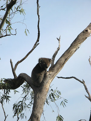
Seriously, she said she was keen to see some koalas. I suggested we make koala-mating sounds, you know, to bring out the koalas. Kate's was the best (I didn't even try). We had learnt 
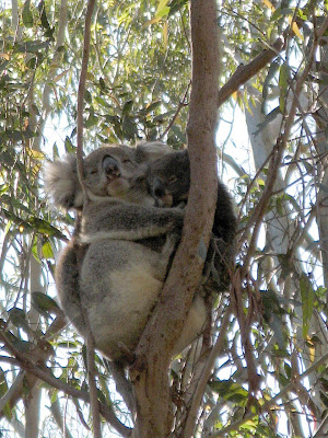
last hike on the Yurrebilla that they sound like wild pigs. Within fifty metres we came across our first koala, and, thanks to Kate's koala mating sounds, a wide awake one (any Aussie would know this is rare). After stopping and letting Marie take some photos, we hiked on, coming across another koala. It soon got tedious, another bloody koala. Although we saw two baby koalas too, very cool.


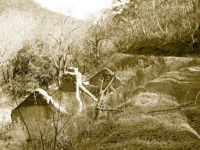
All the koalas, except one, were within about 500 metres of each other, on the descent into Horsnell Gully. I quite liked this gully, I've never been here before, beautiful. A couple of really cool ruins too. And Jenny had said it was a tough hike out of the gully, which it was, but not as hard as the one out of Ambers Gully near Athelstone.


The day's hike started with what looked like was going to be a long road hiking section. Hey, yeah cool, welcome to an real Aussie bushwalk Marie... not! Thankfully, the map was shit, and it ended up being not so far, relieved to see this arrow leading onto a secret winding path.


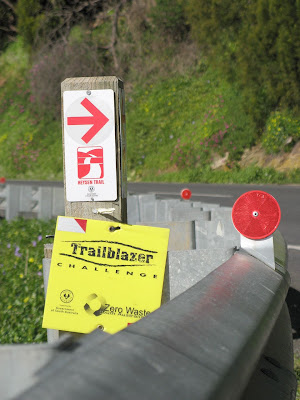
Good too, that much of today's hike was also along the 
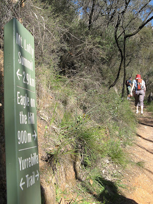
Trailblazer trail. Although we didn't walk very fast, we did the 16 km in 4.5 hours walking time (I think), that's 3.5 km/h. Jenny hiked the Montacute to Mount Lofty section, similar to what we did today, on Sunday, as in tomorrow, which was today, cos even though this post is labelled Saturday I am actually writing it Sunday night.

Walking through Waterfall Gully, from Mt Lofty to Eagle on the Hill, was beautiful. Now I know what you are thinking right now... "Jeremy, he's a keen hiker, born and lived in Adelaide, he would surely have hiked the Waterfall Gully to Mt Lofty summit hike before, if not many times?" Well, no actually, I never have. It's a real beauty though, but not so keen on the bitumen path.


Hiking up out of Waterfall Gully, we over-shot the car - because of my poor map... or poor map reading skills... I have purchased a GPS unit on Ebay, and had I been using it today (today as in Saturday - remember we're pretending I wrote this on Saturday) we would have known we were about 30 metres from the car and not have over-shot it. However my Express Post - "guaranteed overnight delivery to major cities" will take over a week to arrive ex Sydney, thanks to next week's APEC summit.

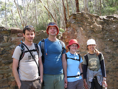
A good day's hiking. Nice photo below, but I think Tim and I should be on the far side, not the near side... we look like giants compared to Kate and Marie...


Oh, the plus one? Tim found a foetus on the track later on in the day. We figured it might be a koala, fresh one it was... but really hard to know.


Saturday, July 28, 2007

Tough hiking - but I didn't let on

I was accused of not letting on that I too, the well seasoned hiker, was finding this hike difficult. But that climb at the northern end of trail, along Ambers Gully, was bloody tough.

The Yurrebilla Trail
Section 5: River Torrens to Morialta
Section 4: Morialta to Norton Summit


We have had plans to hike the 54km Yurrebilla Trail for some time now, and our need to do some training hikes in preparation for doing the Overland Track in January 2009 (yes, 18 months away) was paramount (in the past 12 months, we'd only hiked in the Flinders for one weekend).

So we met in Norton Summit, leaving a car there before driving to the end of the trail, near Linear Park/River Torrens at Athelstone. The Yurrebilla Trail goes from Belair National Park to the River Torrens, some 54km divided into 5 sections. Today we hiked 2 sections, Section 5 and Section 4. Section 5 was listed as 'hard', 13km and 5 hours, and Section 4 was listed as 'moderate', 7.5km and 2.5 hours. The whole 19.5km we hiked took us 6 hours.

Ambers Gully was a delight (through Black Hill Conservation Park), albeit short lived perhaps as the steepness of the grade soon had us thinking second-thoughts. It was at this point, that perhaps, I should have let Tim and Kate know I too thought it was quite tough. Apparently Kate was too busy panting to notice me doing likewise. Tim and I heard what sounded like a wild pig, but turned out to be a koala. I'm not much of an animal spotter, and have never heard a koala in the wild before. I've only ever seen them all drugged up and sleeping. We hiked up to the summit of Black Hill, and down into the valley which Montacute Road passes. A steep climb down, I'm glad we hiked the direction we did than have to hike up this steep climb out from Montacute Road.


Following Montacute Road for a little less than a kilometre, we then hiked up into Montacute Conservation Park. There were a couple of tough sections. Tim grew increasingly quiet, so we fed him some Snickers and he pepped up. Entering Morialta Conservation Park, we ate lunch at the Deep View Lookout overlooking the fast flowing First Falls. A spectacular viewing platform, I was really impressed with hiking through Morialta Conservation Park. I had forgotten how good this place was. We hiked past the Second Falls and onto the Third Falls. It was here, we found a sign stating that the trail was closed due to washed out bridges and rock slides. We didn't know it at the time, but apparently it has been like this since at least August last year. We hiked on though, as we were committed with a car at each end of the hike.


Nearing Norton Summit, we took a short cut of about 150 metres, cutting out at least a kilometre of up and back. We saw the old barns, also part of the trail, from the road, and cut this section off too, saving perhaps another 300-400 metres. Arriving back at the car, we enjoyed some light snacks at the pub at Norton Summit.


The Old Barns which the Yurrebilla Trail officially passes through