Saturday, January 16, 2010

The Routeburn Track – Hilary’s Walk

Hilary suggested – no, demanded – that we include the Routeburn Track on this, our first tour of New Zealand’s hiking trails. Even half way through the first day’s hike I thought she might be right.

Three days on the Routeburn Track, New Zealand


These things can be subjective, the clear blue sunny skies could have played a persuasive part. The Humpridge Track, which we recently completed, yielded none of it’s views so dense was it’s fog. The Kepler Track tried hard with it’s gusty winds, blizzard and endless rain. But weather considered, the Routeburn Track was the best track – thanks for the tip Hilary.

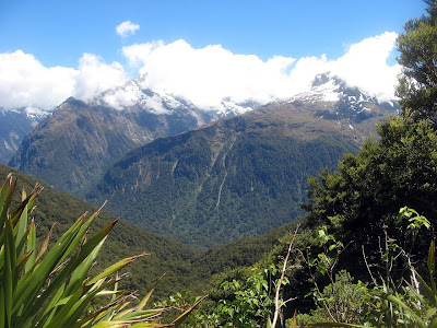
The trail – or, at least, our experience of it – was one that soaked the senses. Yes, the bright sunshine and cloudless blue sky we had seen so little of in Fiordland, but the trail seemed to tease us in and out of the treeline to show us silver beech forest and stunning mountain panoramas. The Hollyford Valley before us seemed to stretch forever, with the river winding it’s way along the valley floor. The trail was interspersed with waterfalls, both large and small. Even at the smaller ones one could breathe – smell even – the cool, moist air and feel it cool one’s lungs. Urged on I filled my water bottle from it so I could taste it delicious fresh pure mountain taste. These falls were a mere hint of the falls we could feel thundering around the corner. Could I feel the waterfall’s might underfoot? To stand and gaze up into the mist of a mighty fall as is shared all with you is quite something.

Green valleys, lakes, rivers, snow capped mountains feeding waterfalls – it’s so hard to describe. I’ve not taken many photos on this three week holiday, most have been taken by my travel companion. Quite why I have taken so few, even to the surprise of friends, I’m not quite sure. Maybe over the years I have taken too many and have reached my limit? Maybe I would prefer to remember a place rather than be busy photographing it. One can come across these places and spend time seeking out different angles and compositions – or indeed, just point and shoot – but perhaps all one takes away is photos and some poor memories, the photos further serving to backbone the memories. I would just stand and try to take in what was around me, trying to commit to memory this moment in time. Let me share an experience with you, a few mere moments of my day. For those of you unenlightened ones, I took some of the first photos since the early Milford Track, so just scroll down for a mere glimpse of what the Routeburn has to offer. Anyway, my day’s moment:

A hut downstream, I was sitting in a carefully chosen location which seemed so far way from it, but at the same time was only a short stroll upstream. The stream emerges from the dense, shady beech forest nearby. Far above I can see the water fall over the mountain edge from a long, hanging, valley to make it’s way past me. From the forest, the stream winds out into the valley, the steep mountain sides standing in such contrast to the wide, flat valley floor. The stream, it’s cool, aqua tinted waters passing quickly over it’s flat rocks riverbed, the water so clear and pure that without the noise and waves it would be hard to know it was even there. The stream sweeps a wide arc out into the valley to merge with the another arm of the river to create a larger stream – no, river.

The valley is filled with grasses, such a wide variety, the wind blowing waves through the longer grass. The trees on the mountain end abruptly where the steep mountain inclines meet the flat valley floor – nature has drawn a sharp line ad both the grass and trees know not to cross over into the other side. From these trees one can hear what seem like all manner of birds. The trees climb as high as they can, but altitude defeats them, and again as if a line has been cut, they grow no higher. They do not grow less dense, or smaller, but are densely treed until that line is reached. Above them the mountains soar, so high the clouds roll over the top of them. Only occasionally do we glimpse the snow capped peaks.

From where I sit I can see all this, as the wind brings the gushing water sounds from different parts of the valley as it chooses. The river has issued it’s invitation to join it, so I step into the cold water as it envelopes my limbs, finally sinking beneath it. The cold is not a problem, for I know that in a few moments I will be lying in the sun upon the grassy bank as the warm sun and cool breeze blows over me.

How was that my friend? Still itching for a photo, can our well trained minds visualise such a place without a photo? Well, I took no photos – none could do this place any justice, they would merely reduce it to a million flat pixels, just a portion of the enveloping panorama, and hint at nothing of how this place feels. Should I add a few other things such a photo – if there was one – might show? I hesitate to note these, these things perhaps I do not wish to remember. One is the humble sandfly, which cannot be escaped with so much skin being made available to them. Secondly, is the niggling thought, the bird cries – as numerous as they seem – are nothing to what they once might have been. Birds, once the king of animals in New Zealand, indeed, so dominant were they that many lost the ability and need of flight. These birds began their long journey down the extinction path when they first encountered man one thousand years ago. Even two hundred years ago when the European explorers sailed into Doubtful Sound in Fiordland, they could not hear themselves think for all the sounds of the birds.

There were many other sights and experiences, or course, camping beside a crystal clear mountain lake surrounded by soaring mountains; crossing the Harris Saddle; the Routeburn itself – the river – not the track); and the Routeburn Gorge with it’s moss wall of falling water, it’s illusions of glass green water. For these I suggest you follow Hilary’s advice and undertake this walk yourself. For those of you who skimmed over this text, as we are wont to do, I present – perhaps with some reservation – a small selection of photos.


The above map data does not come from my GPS unit, I accidentally deleted all files from my GPS unit losing this map. This is someone else's file.

Wednesday, January 13, 2010

The Humpridge Track

It rained all night, the morning was cloudy, windy and miserable. We had a rental car to access the Humpridge Track, the bus schedule had been to troublesome. Driving to the start of the walk seemed to heighten the foreboding, a bus trip is such a passive effort to begin a walk. Here, we had the choice to bail.

Three days on the Humpridge Track, New Zealand


The Humpridge Track has astounding views, although we only knew this from the postcards they sold in the huts. We saw no views from the moment we began our mountain ascent to the following day when we came back down. We did our biggest single-day ascent in our NZ trip, to reach Okaka Hut, just the other side of the mountain top. We did this without seeing the mountain either ahead, below or beside us. This hike was in clouds. It was a muddy ascent, which we had expected, and some 10 kilometres of boardwalk saved us some of the worst of the mud.


This is a private track, despite being in Fiordland National Park, crossing private land and Maori lands. The huts are a step up from the DOC huts – dining rooms, gas heated lounge/dining areas, all utensils and cooking equipment supplied, and breakfast provided too – all for the standard $45 DOC hut fee (the peak season hut fee on Great Walks.) There were drinks and snacks for sale, and, what is this, hot showers. There is more upselling here, heli-packing – your pack transported between huts by heli. Even a heli-exit if need be.

Near the hut there was a small loop walk around the sandstone tors and tarns which I had been particularly looking forward to, but to which the clouds yielded nothing. Perhaps of equal to the views – I wouldn’t know – is Port Craig. Here, down from the mountain and on the coast, was a former logging tramway and town. Four large timber viaducts span rivers, one of them, Percy Burn Viaduct, is purportedly the largest surviving timber trestle bridge in the world.

The tramway network had been built in the 1920s to a high standard, much higher than normal. Advanced technological machinery was brought in from the US, all part of an ambitious plan to log the area. The railway network, with it’s cuttings, square sleepers, low grades and bridges would serve as a foundation for the railway that would be built when the land had been cleared, and would service the new farming land. Spur tracks were built, with radial haul tracks, to clear the forest in the most efficient method.

The viaducts, in use for a mere five years, had a life expectancy of 50 to 70 years. The Percy Burn Viaduct, the highest in the world, bankrupted the contractor who built it. Built from Australian timber, it slowly decayed. By 1990 it’s state was so poor, and it’s collapse so imminent, complex engineering drawings were made of it, so it could live on in some form. The local community rallied together to raise the money to restore it and the other viaducts. The same community met rallied again years later to build the Humpridge Track, utilising the viaducts they had saved.

The mill’s capacity was high. Milled timber accumulated on the beach, the rough seas and boat loading mechanisms unable to keep up. This, even though the tree density was never as high as initially estimated.

By 1928 the mill enterprise collapsed in the face of the Great Depression. On the Friday night workers were told the mill was closing, and this being a company town, they were all to leave on a boat set to arrive at 9am Monday morning (there was no road access to the town). The company was wound up, sold for merely 10% of it’s value. The purchasing company, still in existence today, operated the mill for just 11 months before mothballing the mill and town. By 1939, the town and mill had been dismantled and shipped off for scrap. All that remains today are the ruins of the mill and wharf, and the school building. The school building came quite late in the town’s history, as is government’s tardiness. The company had built the first school, on the beach, and then surrounded it with a stockpile of timber. So much timber, that only the roof is visible in photos. So from there the government stepped in. The school today is a DOC hut for hikers. The Humpridge Track has a village like set-up of buildings, all new.

When we had nearly reached the hut, we passed a woman walking slowing. Testimony as to why every walker should carry a map, she had become separated from her walking partner and she had retraced her previous day’s steps. Her companion had walked the correct way, but soon realised she was nowhere to be seen. Retracing his steps. He found her back at the hut, the very hut they had spent the previous night. It seems she had set out first as he, being the faster walker, had swam at the beach.

I too, immediately upon setting my pack down beside my chosen bed, walked down past the mills ruins to Mussel Beach and the former wharf of Port Craig. I stood looking out to sea for a while, before going to a swim. I ran into the water, but retreated a little due to the intense cold. Moments later, still knee deep in water, fins appeared close to me. Being a South Australian, we act as if fins mean a shark first, think later. Yes, they were dolphins. I was a little freaked out, they swam around me in an arc. I think if someone else was with me, I would have actually swam, and I think the two dolphins would have swam right up to me.

I later discovered that these two dolphins are two of the three Hectors Dolphins that live in this small bay. Indeed, I saw the mother and calf. These Hectors Dolphins are endangered. Endemic to New Zealand, they are some of the smallest and rarest. Maori named them Tutumairekurai, which means ‘special ocean dweller’. They are the only dolphins with a rounded dorsel fin. They are also in the North Island of New Zealand, but are a separate sub species and are physically and genetically different.

The walk out on the third day was quite flat, but still good. I saw a tree I was quite excited to see, the Toothed Lancewood. I have an Icebreaker t-shirt, one of two I wore in NZ, which has a design on the front representing the leaves of the tree. I shall quote from the inside of my t-shirt:
The Toothed Lancewood (Pseudopanax Ferox) is a small endemic tree to New Zealand, it is sometimes referred to as Fierce Lancewood due to it’s sawtooth juvenile leaves.


The above map data does not come from my GPS unit, I accidentally deleted all files from my GPS unit losing this map. This is someone else's file.

Friday, January 8, 2010

The Kepler Track

“The Weka… pure evil.” Some thought this harsh, but really, as experience will show, the Weka are evil.

Three days on the Kepler Track, New Zealand


A native bird of New Zealand, like all indigenous bird species, they have had a predator-free experience. Which makes us humans, and in particular our disgarded boots and wet clothing left strewn along hut verandahs, susceptible to their wily ways.

Along the Milford Track they had been quite troublesome. Cartoon drawings left by hikers at Dumpling Hut depicted Weka dragging hikers aways by their boots. A seemingly unlikely tale but one that gaining credibility the more we heard.

Becky, for one, saw through their cute behaviour. Having returned to the car after a day hiking with Bill, her bf, they found one sitting atop their car, surrounded by pieces of apple. And a crowd of photographers recording it all, all claiming innocence in the part of having fed the Weka. Clearly there are some who do not heed the warnings not to feed the wildlife. The bird, it seems, are a whole lot smarter than some of us. In a magazine we found in the Kepler Track huts we read a story of Weka who having watched numerous hikers unlock and lock a Backcountry hut door, decided to do likewise in the wee hours of one morning. The hikers woke early to climb a nearby summit, only to found they had been locked in from the outside. Thankfully we were staying in a Great Walks hut, considerably larger and having conventional doors and multiple exits.

Now Becky asked me – this walk isn’t all about Becky, we did meet other people – which of the three walks we had done thus far was the best. The Kepler Track, it was clear. The Abel Tasman Track had lots of great beaches, but we are spoilt for them back in Australia. There were people everywhere, with so many water taxi, kayak and car access points. The Milford Track, the walking was very controlled, and almost all the walk is contained to two valleys. The Kepler Track though was special: beech forest, alpine terrain, river valley and lake side paths.

The walk starts at beside Te Anau Lake – New Zealand’s largest. Moving through flat, dense beech forest it reaches Brod Bay, seemingly infested with mice and sandflies. It ascends through different beech forest habitats, broken only by a line of dramatic cliffs, opening to a colder and somewhat different beech forest. All the more creepy with it’s various lichen, we walked higher to the edge of the treeline. Always – it seemed here – a sharp imaginary line cutting the forest from alpine. Standing just inside the treeline, a fierce wet wind blew in. From here we struggled through the cold, wet, windy – and viewless – alpine track to the first night’s hut on the side of Mt Luxmore.

Isobelle had joined us for this first day’s walk. We had met her in the carpark. As a lone walker from Germany, she was keen to undertake the walk with the safety of some of other people. My travelling partner had agreed, but no sooner had we been introduced but my mate had gone far ahead, not to be seen again until that evening’s hut.

In the carpark we had also seen our friends we had met on the Abel Tasman Track. Liz and Rick were beside their car making their final preparations for the hike. When we had me them at the campsite at Wharaheke Bay on the Abel Tasman Track we were disappointed to discover that we would miss them by one day on this track. Imagine our delight to see them here in the carpark, readying to set out.

Leaving them in the carpark to their last minute readying, we did not see them again until they stumbled into the hut later – dripping wet. Like a scene out of some western movie, everyone in the room stopped talking and turned to gaze momentarily upon the newest visitors, before returning to their drinks and conversations. It was the same welcome we had received, a rather uncomfortable experience. After walking determinedly through the alpine section with that fierce head-on wind, I had somehow imagined a warmer welcome.

The second day held much promise, especially when one disregarded the usual Severe Weather Warning. The Milford Track had been a series of Severe Weather Warnings, I was beginning to think they were routinely issued everyday to trampers here in New Zealand. We set out from Luxmore Hut into the cold, cloudy sky weather. However within minutes gentle snow started falling. Rain I first thought, being the Australian more accustomed to hot weather rather than these cold weather phenomenon, but soon I wasn’t so sure. Our new friend, Berta, who we had met the previous night in the hut, being a Belgian, declared it to be snow. I wonder if she noticed our uncertainty to make such a call. We walked through what soon became fierce snow for about an hour. Head down, following the footsteps in front , focusing on reaching the first of the two emergency shelters available today. Berta, like Isobelle the day before, had asked, as a lone traveller, if she could join us for today’s alpine section. Isobelle had decided she was ill-equipped for today’s alpine conditions and weather forecast, so opted to return back the way she had come. Today Berta was filled with a moment of terror as my travelling partner strode off quickly from the Luxmore Hut. She was relieved, trying to keep up, to turn around and see me some way behind her. Berta, we soon learnt, had also never hiked through snow. Becky and Bill, both being from the UK, later reliably informed us that we had not merely walked through snow, but through a blizzard.

The snow eased just before we reached the first emergency shelter, but we were still grateful to get out the cold wind and snow. Eagerly eating our snacks, the sun – quite unexpectantly – shone through the frosted glass windows of the hut. Emerging outside into the glorious sun, the clouds parted to reveal the valleys, burns, lakes and distant mountains surrouding us. With wonder we walked beyond the next emergency hut, eagerly taking photos of our new-found scenery. Berta stopped me once to point out to me the waterfall on the other side of the valley, falling over a steep cliff. The wind was strong, and we had already noticed that the water was swept away by the wind before reaching the pool below it. But now, for a few moments, the sun shone upon it and showed a most glorious rainbow in the water cloud.


By lunchtime we began the descent back down the treeline on the opposite side of the mountain, to be met by walkers just coming up from the second night’s hut beside Iris Burn. Waiting out the blizzard, they had just started their walk, in the reverse direction to us, now reaching the most dangerous part, the alpine section. Seemingly ignorant of the Severe Weather Warning issued for the afternoon – heavy snowfall – they set out now. No sooner had we descended past the treeline and the rain began to fall. No doubt there would snow falling high upon Mt Luxmore, indeed it rained constantly for the rest of the afternoon and night. The next day, from the safety of the hut on the valley floor, we looked up to see snow capped mountains surrounding us. The snow covered even the highest few hundred metres of the trees below the treeline.

We had booked only a campsite beside Iris Burn Hut, but were grateful for all the cancellations that allowed us to upgrade to a bed in the hut. Free of the burden of an afternoon spent in a tent with rain falling, we could spend the afternoon chatting and drinking warm drinks with our friends.

The final day, due to the 30cm of snow covering the alpine track, that section of the Kepler Track was closed. We were still able to walk out via our intended route along the Iris Burn, combining our last two planned days into one – we didn’t realise how short the final days would be – we walked out with Liz, Rick, Becky and Bill to Rainbow Reach. From here we caught a minibus service driven by what was quite possibly New Zealand’s grumpiest lady, back into Te Anau. We now had two days rest instead of our planned one day’s rest, which we suitably filled with a long sleep-in, a short scenic documentary and a delicious meal in a cafĂ©.


The above map data does not come from my GPS unit, I accidentally deleted all files from my GPS unit losing this map. This is someone else's file.

Tuesday, January 5, 2010

The Milford Track

A Severe Weather Warning was issued – we were surprised, of course, but should not have been. Later it transpired these were to be common during our time in New Zealand.

Four days on the Milford Track, New Zealand


This aside, it was a sunny afternoon when we collected our tickets and caught the afternoon bus to the ferry. With our 40 other independent walkers – albeit less three New Zealanders – we set caught the ferry to Glade Wharf aside Lake Te Anau to commence the four day hike. The first day was only an hour and a half – if that – but this walk is strictly managed and we could walk no further. Three New Zealanders had left their lodgings near the ferry wharf to wander down to the ferry in a timely manner, only to see the ferry disappearing over the horizon. Tickets on the Milford Track at this time of year were hard to come by, we had booked early, and had met many travellers during our stay in NZ who had missed out. Tickets and accommodation all booked, it seemed a waste to leave it at that, so they called in a helicopter to fly them to Glade Wharf. Expensive, maybe, but a credit card charge the father hoped to conceal from his wife who was back in Nelson. I hope he budgeted for the bribe money he would need to hand over to keep his two children on this walk quiet about the whole matter.

The first hut – Clinton Hut, was nicely sited. An attempted swim in the river was thwarted by the icy temperature, so I returned to the hut to sit outside and read awhile prior to dinner. Many of the indie walkers had joined the Hut Warden for a nearby nature walk – but not all had. So why was no-one else partaking in a pleasant seat outside prior to dinner? A Texan couple we had met and my travelling companion had all retreated inside. It took just a few moments of being still, the problem became all too clear. Sandflies, and lots of them, had come to check out their lone prey. They say much of the reason why the Fiordland remained untamed can be attributed to these little – but rather pesky – sandflies. The Abel Tasman Track had them in plague proportions, that we had been expecting, but this here we were not. On just one leg, my bite count had increased from the 42 bites from the Abel Tasman Track to the 87 by the third day on the Milford Track.

The evening was calm and warm, which just made the following day’s weather forecast even harder to comprehend. Rain, and a deluge of it. Rain overnight, followed by 30ml of rain per hour, sustained for six to eight hours. Some quick maths, yep, 180ml plus in one day, this on top of the 170ml that had fallen on the track the day before we had started out on it. This 350ml of rain, more than half of our hometown Adelaide’s annual rainfall. The track would be closed, almost certainly, so the following morning we awaited the updated 8.30am weather forecast. We weren’t permitted to leave the hut and proceed to day two’s hut until the report had been issued. As it was, it didn’t sound any better. In the end, it fell just short of us having to hold hands and skip down the track together. All 40 of us were led by the hut warden to the next hut along the track. Of course, this was meant to be an indie walk, no guides. But with the prospect of wet walking, no, swimming, we were guided for eight kilometres up the track. First through ankle deep water crossings, then through waist deep water. Some of it still, some of it a raging river torrent as the river broke it’s bank to make the river and track one. Halfway to the next hut he called it quits, no good, already waist deep we would be chest deep very soon. This would pose a challenge to the kids and the shorter members of our group.

So waiting in a large clearing created by a rockslide some years previously, and surrounded by a wall of waterfalls coming down almost every mountain fac, we waited for the heli evacuation. Soon the guided walkers arrived, but their premium fees to walk this track got them on the heli’s no quicker. I’m not quite sure why the need for the heli evacuation, we could have simply turned around and walked back to Glade Wharf and the ferry, but we were to be heli’d to the next hut. Does money talk? Facing losses of up to $90K per day, the $20K cost of the heli’s was nothing to keep the track open. $90K you ask? Well, we paid only $45 per night, but the guided walkers with their motel style accommodation paid $2,000 for the trip. Of course this is my cynical side talking, maybe the heli solution was just meant to ensure no-one would miss out. But strangely the offer was not forthcoming on any of the other smaller (and less income earning) tracks.

Our third day we were free to walk again as the track was crossing over the top of the two valleys, indeed an alpine crossing. The alpine heights offered us limited views as the wind and rain set in. Thankful for the emergency hut, we were not to see the famed views down the Clinton and Arthur Valleys.

Nearing the third hut, we could see much trampled grass. According to the flood indicator markers, this areas had been under two metres of water recently. After what can only be described as a bone chilling swim, I again attempted a reading experience on the hut verandah. I sprayed insect repellent on one leg but not the other – my controlled experiment – but it made no difference, indeed, I think the sandflies preferred the repellent sprayed leg.

The final day saw us walk out out of the Arthur Valley to another ferry, to take us across Milford Sound, to a bus which would take us back to Te Anau.

On the whole the guided walkers were more poorly equipped. On the ferry across Milford Sound, I sat beside one wearing her down jacket to keep warm and dry. Down jackets – as you may know – can be very warm, but will be neither nor dry if it gets wet. Of the indie walkers, only two were perhaps a little under equipped – two Zimbabweans dressed in rain jackets, but boardies and runners. The shoes were no less waterproof than our Goretex boots which are of no benefit at all beyond ankle deep water. Indeed, perhaps they are worse, as they do not let the water back out. The two Zimbabweans should be admired though, for in Sutherland Falls they went for a swim. I could not even get close to the base of the falls, such was the rain storm released by their recent water deluge.

Our bus ride back to Te Anau was filled with gruesome detail as the third night’s hut warden, having finished her eight day shift, was discussing with the bus driver the finer points of capturing, skinning and preparing a wild possum to eat.


The above map data does not come from my GPS unit, I accidentally deleted all files from my GPS unit losing this map. This is someone else's file.