With four sets of track notes we were almost assured of success in our plan to climb Mt Giles. The NT's third highest mountain, and as Wild magazine puts it, "For such a prominent peak, with relatively easy access and the best views in the MacDonnell Ranges, it was surprisingly little visited. Not being on the Larapinta Trail had, to a great degree, kept its secrets hidden."
Mount Giles, West MacDonnell National Park, Northern Territory
Over the last two summers it has rained an awful lot out here, unusually so. The rains here come in summer, not winter, the rain from the left-over tropical cyclones from the north. Ormiston Gorge was flooded, people wanting to walk the 7km/3hr Pound Circuit would be rewarded with a very cool swim through the gorge. I gather not many people took that reward, opting to hike in halfway along the circuit, into the pound, then return the same way.
We hiked in halfway, and as the track veered north-east we veered off the track. With Mt Giles in our sights, we trekked across the pound floor, which was by no means flat or easy going. We hopped over rocks, between spinifex and around other more deadly bushes, seeking shade under the occasional tree or, if we were super lucky, stand of trees in a dry creek bed.

Approaching the main Ormiston Creek, which we had not seen up close since our shortcut across the pound, I saw what looked like shimmering water. The mind plays funny tricks, I thought. I gather Graham may have been thinking similar things, neither of us confident enough of our own eyes to make a call about water. Just as I convinced myself the appearance of water was caused by a strange mix of shiny rocks and grasses, a bird landed on this strange surface and caused ripples across it. Strange rocks indeed. We couldn't believe it, none of the track notes we were armed with mentioned water in the creek, quite the opposite, they all mentioned the lack of it. Making a bee-line for the water, we were rewarded with what seemed like endless pools of water. We wouldn't need to search out the illusive springs on the side of Mt Giles, or any lingering pools elsewhere.
Following the creek upstream we got wet, muddy boots, most unexpected. We even caught sight of some fresh foot prints, there were others out here recently. Having chosen a nice campsite out of the hot sun, on the sandy banks of Ormiston Creek, aroundabouts where the national park people recommended you camp (there are no formal campsites out here in the pound), it seems we had lucked on the exact spot specified in the main track notes we were using. With a couple of nice pools of water, we relaxed in the late afternoon shade and contemplated the madness of climbing Mt Giles which dominated the view before us.
The following day, somewhat before sunrise and when it was still cold, we headed off carefully following a set of track notes.We sidled up to the mountain base, and sure enough the spur ahead of us looked like a good option. Up we went, it was very steep to start with, almost scarily so, but the hardest bit was this first section, each higher section was gradually flatter until we eventually came upon the false summit, large and rounded. Now Mt Giles and it's distinct tin-on-a-pole cairn visible in the distance, we strolled along the ridges and saddles and made the final climb up to the summit.

 From the top we looked around in every direction, generally ignorant of what we were seeing. I spotted a few landmarks, Mt Sonder, that so illusive Mt Zeil and Gooses Bluff in the distance. Scanning through the logbook, we were only the sixth party up here this season (there seemed to be seven to 11 parties each year), we noticed the many references to the south spur route up. People had been making some pretty quick times up. We had followed John & Lyn Daly's notes, from Take a Walk in Northern Territory's National Parks (referenced below), which could very well be the same route described by John Chapman in his Bushwalking in Australia book, although scanning through the book back in Alice we could find no mention of Mt Giles. A Wild magazine article from last year mentioned a quick, direct route up, but was lacking any good directions to find the base of the spur. Up here though, it seemed all to obvious, so down we went. Indeed it was quick and direct, the grade was steady and unrelenting, but easy enough. Both spurs offer numerous routes forward of each step, but the route up involved quite a few grade changes, flat spots, a false summit and much ridge walking. This southern spur was direct, constant and only 1.45km long (the route up was 2.2km). The grid reference for the base of the quick spur is 793827, for the longer spur 786827, check out the track notes on the topo map below.
Back at our previous night's campsite at lunchtime, Graham didn't take much persuading to convince him of the benefits of laying low in the cool shade under one of the big gums lining Ormiston Creek. So instead of hiking out, or over to Bowmans Gap in the other corner of the pound, we sat and read the afternoon away.
The third day, once again setting off super early, we made excellent time in the cool of the morning and were soon back at the car.
The sun had been bloody hot, the shade refreshingly cool, sometime positively cold. Hiking in the mornings had been a good thing. It seems only too evident now that last time I was here hiking the Larapinta Trail, I had benefited from the two months in the tropics of the Kimberley and the Top End to acclimatize to the heat. Dropped in here from the cool south's winter seemed to make the afternoon heat just a little too much.
- Overnight Walks or Ormiston Gorge, official national parks leaflet
- Take a Walk in Northern Territory's National Parks, by John & Lyn Daly, Take a Walk Publications 2006, ISBN 0 9577931 5 4. Walk article titled Ormiston Pound, Mt Giles, Bowmans Gap Circuit, pages 224-228
- Wild magazine, issue 119 September-October 2010, pages 24-28, article by Michael Giaometti from a hike on 25/7/07
- Mt Giles deviation in Ormiston Pound, a subsection of the page titled The Larapinta Trail, Central Australia by Roger Caffin
 References:
- Have you hiked up Mt Giles? If so, which route did you take?
- Where did you find water?
| View in full screen format Download GPX file - for use as a navigational aid in a GPS unit Download KML file - view in Google Earth |
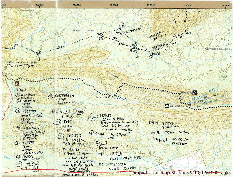
TRACKNOTES - Mt Giles
The route we took going to the basecamp follows the creek more, this is good for afternoon walking, and to find water.
The route we took returning from basecamp to the carpark is more direct, it is better for the cooler morning as it involves more cross country ups and downs, and less shade.
The down route from Mt Giles to the base is probably the better of the two spur routes to summit the mountain.
|
Day 1 |
|
|
Ormiston Gorge carpark to Mt Giles basecamp |
|
|
Waypoint |
Comment |
|
1 - Ormiston Gorge carpark |
11.20am |
|
2 |
GR709844 12.30pm/4.3km |
|
3 |
GR722844 Break (tree) 12.55pm/5.49km |
|
4 |
GR746843 lunch (trees) 2pm/2.30pm/8.12km |
|
5 |
GR758842 Ormiston Creek (water pools) 3pm/9.55km |
|
6 |
GR765831 3.40pm/11.01km |
|
7 |
GR772822 4.17pm/12.38km |
|
8 - Campsite |
National Park recommended campsite Ormiston Creek 4.30pm/12.65km |
|
Day 2 |
|
|
Mt Giles basecamp to Mt Giles summit and return |
|
|
8 - Campsite |
Leave 6.55am with daypack |
|
D2-2 |
GR783825 7.18am/1.29km |
|
D2-3 |
Base of mountain and spur GR786827 7.30am/1.72km |
|
Mt Giles summit |
9.30am/3.9km |
|
Mt Giles summit |
Return downhill, leave 10am |
|
D2-4 |
Base of direct south spur GR793827 11.20am/5.34km Plenty of suitable campsites here in creek |
|
8 - Campsite |
Arrive 12.20pm/7.86km |
|
Day 3 |
|
|
Mt Giles basecamp to Ormiston Gorge carpark |
|
|
8 - Campsite |
Leave at 7.15am |
|
D3-1 |
GR765829 Fence 7.45am/1.41km |
|
D3-2 |
GR757836 8.05am/2.58km |
|
D3-3 |
GR747843 8.30am/4km |
|
2 |
9.15am/7.8km |
|
Ormiston Gorge carpark |
10.50am/12.07km |
| GPS Stats |
Mt Giles | ||
| Wednesday | Thursday | Friday | |
| 24/8/2010 | 25/8/2010 | 26/8/2010 | |
| Ormiston Gorge carpark to Mt Giles basecamp | Mt Giles basecamp to Mt Giles summit and return | Mt Giles basecamp to Ormiston Gorge carpark | |
| Distance | 12.65km | 7.86km | 12.07km |
| Start Time | 9.07am | 6.46am | 7.13am |
| End Time | 4.32pm | 12.23pm | 10.53pm |
| Moving Duration | 3h15m | 3h14m | 2h51m |
| Stationary Duration | 2h00m | 2h21m | 44m |
| Moving Average | 3.9km/h | 2.4km/h | 4.2km/h |
| Overall Average | 2.4km/h | 1.4km/h | 3.4km/h |
| Oodometer | 12.65km | 20.5km | 32.6km |

2 comments:
Dear Jez,
we are doing Larapinta again in two weeks and want to do Mount Giles this time instead of Mount Sonder - your track notes are amazingly detailed and will be invaluable to us - many thanks for posting online -
Dear Jez,
we are doing Larapinta again in two weeks and want to do Mount Giles this time instead of Mount Sonder - your track notes are amazingly detailed and will be invaluable to us - many thanks for posting online -
Post a Comment