The wildfires were burning on the Larapinta, even the reopened sections of burnt out, smoke smelling bush didn't seem too attractive to hike. We opted for Plan B. Hike Mt Zeil, maybe Mt Giles and then some more.
Mt Zeil, MacDonnell Ranges National Park, Northern Territory
This blog post is about an unsuccessful climb of Mt Zeil.
I've since made a successful climb,
refer to this July 2012 post.
I've since made a successful climb,
refer to this July 2012 post.
I have planned to tackle Mt Zeil for a couple of years now. It's in the State 8 - NT's highest peak, the State 8 being the highest peak in each of Australia's states and territories. I was up here this time last year, but I was all lonesome, and that's no condition to set out off the track for a couple of days.
With Graham beside me, Mt Zeil presented a very viable option. Most people used to access the mount from the northern side, driving a 4WD - or a few brave souls 2WDs - along the Tanami Track, then along some isolated bore access roads until they or their cars could drive no more. From here it was a short 6km up to the summit. That route is no longer an option, that pastoral station on that northern side has closed that access route off.
I hadn't yet contacted the ranger here at West MacDonnell National Park, he is widely held to have the access info from Redbank Gorge, I had planned to do that later this year in preparation for a tackling of the summit next year. Plan B was enacted just a day before we left for Alice, so there was no time to contact him then. I had already thought a walk in from Redbank Gorge seemed a much better option than hiring a 4WD and tackling the Tanami Track and bore roads.
We parked our hire car in Redbank Gorge, possibly the world's smallest car, and our packs full of weighty water, we set off through the gorge. Our base load was 11kg each, but adding 9 litre of water too that hefted that weight up somewhat.
Redbank Gorge posed our first problem. It is a narrow gorge, full of water. So we hiked up and around it, quite an adventure in itself, all to avoid getting a bit wet. Next time I thought - why would there be a next time - we should float our packs through and swim for our dear little lives. Surely a refreshing swim in water that never sees the sun, perhaps three or four degrees, would be pleasant enough compared to hiking up a scandalously steep gorge?

Safely through over to the other side, I surveyed the scene before us. Mt Zeil lay well off to the north-west horizon, much as expected, and a series of creek fed into Redbank Gorge. It was crucial we set off up the right one, but really that was a matter of choosing the one that seemed the biggest (it really wasn't that hard.)
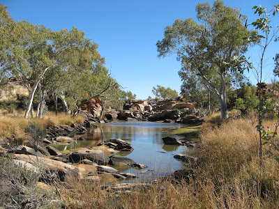 Heading upstream, we experimented a little with walking along the grassy banks, which sounds nice enough was seemed fraught with danger. Rock hopping along, we set off to our major creek junction at GR468942. Ahead of me I soon spied what seemed to be water, was it a cesspool full of half dead-fish? The closer I got the less likely that seemed, we were soon upon an expensive pool of lovely clean water. Or course we would have to share it with those ducks, but I think we could deal with that. Walking further upstream towards that before mentioned junction, we came across a few small pools, and another large pool.
 These all abruptly ended, perhaps they are semi-permanent, but all much too close to Redbank Gorge to be of that much water resource use for our hike. The creek became wide and flat, much like the super creeks of our homestate Flinders Ranges.
Once we reached the important creek junction, we began following the north-western creek. The hills to the right looked more direct, and we were overcome with temptation to take a shortcut. The scrub was freshly burnt out, it seemed like a good idea at the time. It soon turned outright miserable, as we followed the landscape from one saddle to another, eventually emerging not that far where we would have passed on the longer creek-following route. Lesson learnt, we stuck to our creeks from there on.
It soon became all too apparent though, this was a dismal plan. Our speed was slow, the terrain tough. I'm not sure at our current rate we would make it around to the northern side of Mt Zeil, the best place to attempt a summit from. Enraged with summit fever, or just the sheer stupidity of many "best-laid-plans", a shorter and more viable day's hike to the south-eastern base of the mountain seemed like a viable idea. The summit was still achievable, or so I convinced myself while carefully looking over the broad empty contours of the 1:250 000 topographic map. For you novices back at home, a 1:250 000 doesn't show much, indeed for the most part it allows the cartographer to do some very sloppy work. In an afternoon they could map out much of Australia with a few squiggly lines here and there for the biggest of the mountains. I pity those cartographers assigned to drawing up the 1:50 000 topo maps, they're going to spend the rest of their lives steeped in detail of every hill from here to, well, not Timbuktu but somewhere equally remote in this vast country of ours.
We soon broke out of the creeks, the terrain was flatter and broader now, so we set our sights on distance features and made straight lines to them - thankfully, or we would never have got that bloody far from Redbank Gorge.
The sun setting on our hard day's hike, we set up camp in our dry creekbed. Unbeknownst to us, we were camped within a couple hundred metres of the Tropic of Capricorn, who could imagine that just over that imaginary line lay the glorious wet tropics of our country's north. I guess it doesn't really work like that, and I already knew that.
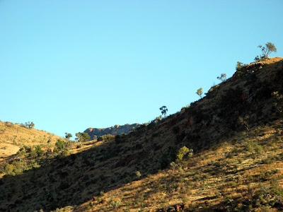 The followed day we set off on our mad plan, neither of us any the wiser to the madness of it all. Atop the first saddle I was little dismayed to see a few more hills than I expected. On we went, eventually realising our plan was right royally stuffed. The summit cairn of Mt Zeil was clearly visible, but oh so long away. We had to give up, we had three days water with us on this trip, scantly that, stretching it out to cover four days in this heat was just bloody stupid.
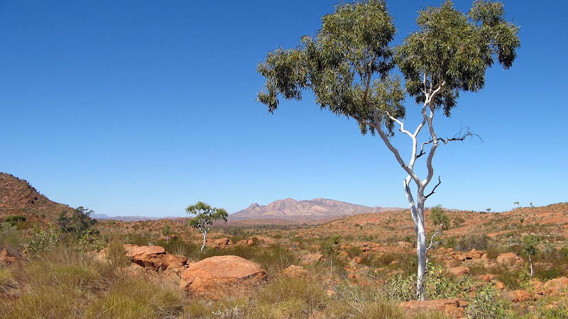
A little bit inside me was relieved, managing our water stocks was somewhat stressful anyway. Back at camp we threw everything back in our packs, and set off in the direction of Redbank Gorge, out destination for tonight's campsite would be one of the two major waterholes we found this side of Redbank Gorge.
Dodging enraged bulls and their fellow cattle, we headed back to our creek system, there would be no shortcuts this time. We discovered these cattle form their own little trails which look every bit like trails designed for people, most are strangely many kilometres long, slowing wandering along creek banks.
We climbed over the fence back into the national park, safe from the crazy bulls, over a somewhat strangely placed chair aside the fence. We weren't the first people to cross here, that much was certain.
That night we were much pleased to reach the first waterhole before sunset, setting up camp after refilling our water bottles. Nine litres each had just got us back here. Sitting back relaxing the local birds put on a show for us, dancing across the surface of the water catching insects, and a couple of willy wagtails doing some kind of foreplay with each other.
Sitting under the cool verandah at Glen Helen Resort, just a few short kilometres drive away, sampling every cool drink we could lay our hands on, we pondered the madness that our scheme was. For one, I really did need to contact the park ranger's name I had been given for Mt Zeil info, there must be water out there somewhere. For one thing, those cattle need to drink something. Being well trained off-track hikers, driving into Glen Helen Resort we spied a small helicopter plying tourists for scenic flights, oh yes, here was another viable option of reaching Mt Zeil at some point in the future. We could charter it to drop us and a whole heap of water out on the northern base of the mountain, summit the mountain on the first day, and enjoy a pleasant day and half's walk back to Redbank Gorge.
Well our reconnaissance to Mt Zeil involved some walking, alas, but many an off-track mountain requires more than one attempt. We are now set to tackle it again with sensible, realistic and achievable plans - a plan that is not the least bit mad.
- Have you climbed Mt Zeil? Let us know how.
- Have you swam through Redbank Gorge? If so, tell us some info, is it narrow? Too cold? How long?
| View in full screen format Download GPX file - for use as a navigational aid in a GPS unit Download KML file - view in Google Earth |
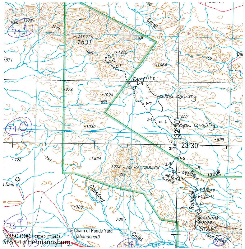
TRACKNOTES - Mt Zeil
The return route is the better of the two routes to follow, no bad shortcuts, follows creekbanks rather than creekbeds.| Waypoint | Comment |
| Day 1 | |
| Redbank Gorge carpark to Mt Zeil base | |
| Redbank Gorge | 8.30am |
| Halfway across above gorge | GR469914 9.00am |
| 1 | In Redbank Creek having crossed above gorge 9.10am |
| 1-1 | First waterhole GR469921 9.50am |
| 1-2 | Second waterhole GR467935 10.42am |
| 1-3 | Major river junction GR468942 11.00am/5.58km |
| 1-4 | First saddle on questionable shortcut 12.00pm |
| 1-5 | Lunch on creek GR448975 12.45pm/10.2km |
| 1-6 | Open country GR428010 2.45pm/15.25km |
| 1-7 | Cattle country GR409032 3.40pm/18.37km |
| 1-8 - base campsite | GR394049 4.45pm/21.4km 5.5+2.5 hrs |
| Day 2 | |
| Mt Zeil base, attempt on Mt Zeil, return to second waterhole | |
| 8 - campsite | Leave 6.45am |
| 2-1 | GR377067 7.41am/3km |
| 2-2 | GR371071 8.07am |
| 2-3 | Turn around 8.20am/4.14km |
| 8/2-4 | Back at base camp 10.02am/8.85km |
| 2-5 | GR423014 12.00pm/14.24km |
| 2-6 | |
| 2-7 | GR744996 1.21pm/17.77km |
| 2-8 | GR441965 3pm/21.3km |
| 2-9 | 4pm |
| 2-10 | 4.20pm |
| 2/2-11 | GR467935 Back at 2nd waterhole for campsite 4.40pm/26.3km |
| Day 3 | |
| 2nd Waterhole to Redbank Gorge | |
| 2/2-11 | Leave campsite at 7.25am |
| Redbank Gorge carpark | 9.05am/3.97km |
| GPS Stats | Mt Zeil attempted summit | ||
| Sunday | Monday | Tuesday | |
| 21/8/2011 | 22/8/2011 | 23/8/2011 | |
| Redbank Gorge carpark to Mt Zeil base | Mt Zeil base to summit attempt, return to 2nd waterhole | 2nd waterhole to Redbank Gorge carpark | |
| Distance | 21.42km | 26.35km | 3.97km |
| Start Time | 8.03am | 6.45am | 7.19am |
| End Time | 4.48pm | 4.36pm | 9.06pm |
| Moving Duration | 5h38m | 6h38m | 1h24m |
| Stationary Duration | 2h37m | 3h05m | 18m |
| Moving Average | 3.8km/h | 4.0km/h | 2.8km/h |
| Overall Average | 2.6km/h | 2.7km/h | 2.3km/h |
| Oodometer | 21.5km | 47.8km | 51.8km |

1 comment:
I can set up my new idea from this post. It gives in depth information. Thanks for this valuable information for all,.. water resistant backpack
Post a Comment