A butterfly just landed at my feet - and it stayed long enough for me to get a photo. That proves beyond doubt that this place is magical.
Day 4: Johanna Beach to Ryans Den
Rated 'medium', the hike to Milanesia Beach features lush valley views and country roads through farmland and forest. Rated as 'hard', the hike through to Ryans Den starts on the beach the climbs steeply to the clifftops with sensational views, continuing through steep hills and coastal forests passing high sea cliffs.
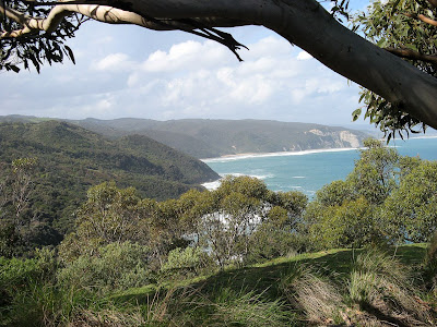
 I'm sitting in a grassy clearing, atop what can only be described as a huge, remarkable headland jutting out into the ocean. From my vantage point, I can see the beach were I had lunch today and the pine forest I walked through on the lands far above it. I can also see the campsite and beach at Johanna where I spent last night. Beyond that, I can see the outlet of Aire River - where I camped two nights ago. And in the hazy distance, quite distinctly, I can see Cape Otway Lighthouse, which I passed on my second day.
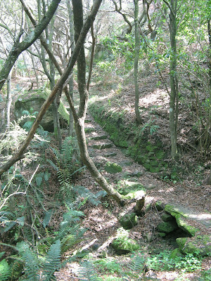
I'm on one of the two grassy clearings at the headland just metres from the Ryans Den hike-in campsite. Not only is this place magical - the views from my tent are amazing - but so too is the hike in from Milanesia Beach. It was a tough hike, the hardest section of the Great Ocean Walk - but this added to the magic. It was very isolated and the gullies seemed almost surreal - green moss covered rocks forming slab bridges and steps, all in the midst of an eeriely quite wet forest. All the time, the distinct headland of Ryans Den loomed far out in the ocean, it's shape like something out of a fantasy movie. The enchantment continued when I came upon a staircase that spiralled seemingly endlesslt upwards towards the campsite.

I left Johanna this morning a bit flat and tired. The wind had beem strong through the night, and the wind was unrelenting. THere was no sight og the sun as I hiked along an old coach road that winded through farmland. The rain came in fast and heavy, but eventually cleared. This part of the hike through farmland reminded me, perhaps a little too much, of the many farmland sections the Heysen Trail passes through. It was then I realised that I have a confession to make to you regular End-to-Enders on the Heysen Trail. It's quite a serious confession for a End-to-End hiker... no highlighter have been in my hand, or on my maps for this whole trek!
The farmland eventually gave way to pine forest, following what I think is the first car accessible road on the Great Ocean Walk. It then entered natural bush, thankfully, before descending to Milanesia Beach. In a stream that entered the sea here - finally - I had a refreshing wash. A swim would have been better, no doubt at all, but that sea had looked scary for days, and it was cooler now, and the sun not constant.
Tomorrow I will hike it home, along the Great Ocean Walk's iconic Wreck Beach, past my pre-booked hike-in campsite at Devils Kitchen back to my car - a beer, hot shower, a pub meal and a powered tent site. Perhaps Friday arvo I will complete the remaining 6km from Princetown to the Twelve Apostles.
View photos in full-screen mode
| I Say | They Say | ||
Distance Total time Odometer Moving time Stopped time Start time End time Moving average Overall average Max speed |
13.8km 6h 25m 69.4km 3h 14m 2h 58m 7.30am 1.55pm 4.3km/h 2.2km/h 29.3km/h ?? |
Distance Total time |
13.4km 5h 30m |
Select alternative blog entry to view:
Day 1: Apollo Bay to Blanket Bay
Day 2: Blanket Bay to Aire River
Day 3: Aire River to Johanna Beach
Day 4: Johanna Beach to Ryans Den
Day 5: Ryans Den to Princetown

No comments:
Post a Comment