It was some climb to Mt Ossa, 4 hours return, and we weren't quite sure which mountain it even was. Was it this one in front of us (it was huge), or was it one looming behind somewhere?
The Overland Track, Tasmania
6 day hike: this blog entry the 4th day
Saturday 20 December 2008
New Pelion Hut to Kia Ora Creek
6 day hike: this blog entry the 4th day
Saturday 20 December 2008
New Pelion Hut to Kia Ora Creek
After climbing 150m from the main track up towards Mt Ossa we asked a passing tour guide who was bring his group back down. Yep, we couldn't see it yet, it lay behind the distinct mountain we could see before us. We had to go up, where we could re-evaluate.
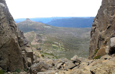 "We've only climbed 300m, we still have 200m to go," I said to the others. "Yeah, we've climbed 300m, only 200m to go," replied Tim, ever the optimist. On we climbed up this mountain through a gully between two larger pillars of rock. It wasn't easy, I gotta tell you I was scared when I looked down. At the top of this formation I sat admiring the view. "I'll climb up there," I said, "it looks easy enough. From there we can see how much further it is to the peak." By this time Andrea and Theo had caught up with us, and Tim and Theo set off up the next ascent. I asked someone coming down how much further it was - I hate asking that - and it quickly became apparent that it was Mt Ossa that lay before us. So I raced up after the other two guys, climbing up through the snow patches, to reach the summit of Mt Ossa. The summit is a plateau, hence our reasoning as to why it wasn't Mt Ossa.
It was such a clear day we could see everywhere, and this being Tassie's tallest peak at 1617m, we were rewarded with views of peaks everywhere. I made a contribution to Theo's friend's website - a website Theo and his friends had all put in together for to pay for the programming and set-up costs as a birthday gift. Perhaps more on that later.
 The descent was quick, just 45 minutes, and despite how scary the ascent was it was easy to return back down. We arrived at camp at 6pm at Kia Ora Creek, our tent platforms placed overlooking the creek with the sun setting on a distant rock face. After a refreshing swim - the waterfall was icy cold - we all ate dinner together and talked with the park ranger Jenny.
Alternatively, visit the Overland Track website to view the official Google Earth kml file. Download kml file to view in Google Earth or adapt to use as a navigational aid in a GPS unit |
| Stats |
Overland Track: Day 4 | |
| Saturday | ||
| 20/12/2008 | ||
| New Pelion Hut to Kia Ora Creek |
||
| Distance | 14.4km | |
| Moving Duration | 3h45m | |
| Stationary Duration | 3h36m | |
| Moving Average | 3.8km/h | |
| Overall Average | 2.0km/h | |
| Oodometer | 76.8km | |

No comments:
Post a Comment