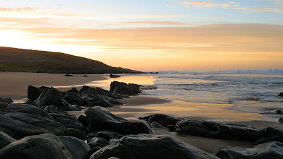
Walking along a picturesque beach, followed by a picturesque beach to camp at. Swim at another picturesque beach, followed the next day by another picturesque beach to camp at. Who could ask for more?
Freycinet Peninsula, Tasmania
 What more is there to say? The first day we negotiated the edges of the Hazards - a collection of mountains named after a ship not their hazardous nature - to Hazards Beach. From here we walked a couple of kilometres along the hard sand - careful not to walk too high on the beach so as to crush the bird eggs or indeed the sand-coloured baby birds if there were any - to Lugunata Creek campsite. Just short of here we had finally caught up with the two parents and seven year old girl we had briefly spoken to in the carpark. The girl was running ahead of the parents and gaining some extra mileage with her wanderings, so I think she would be just fine on her first multi-day hike.
 We walked inland to Cooks Beach where we found the clearest of waters as the waves crashed across the pure white sand. After a swim, who could resist, we sat on the beach and read as the sun set before us.
We started day two with a short 1 hour return walk to Byrans Beach, can you beleive it, yet another picturesque beach? This one was off the main track, but the campers there looked just like car campers. Big tents, shade covers, toilet tents and shower tents, and lots of washing strung up. Were they all wandering around naked somewhere, or perhaps, more likely, they had come here by one of the several boats anchored along the sheltered beach. Their camping style stood in stark contrast to that of the previous night where twenty or so campers set up camp, having carried their tents and gear in on their backs.
 Returning to Cooks Beach, we began our arduous climb from sea level up 579 metres of Mt Graham. From here, in the hot sun, we had a postcard view of the isthmus joining the end of Freycinet Peninsula to the Hazards and the mainland. Ont he left was yesterday's Hazards Beach, and the right, the famous Wineglass Bay. It was a slow steady descent down to Wineglass Bay and our campsite. The long descent put somewhat of a dent in the seven year old's enthusiasm. She had discovered the hiker's secret: maybe just maybe we prefer the hard ascending hikes to the long descending ones?
The campsite vibe here was a little different. There were numerous boats anchored in the sheltered bay, but this time none were camping. However the campsite was strewn with rubbish and empty bottles, and the toilets were, what shall we say, feral. After we had set up camp, a young couple walked off the beach and into the campsite, clearly having walked the short one and a half hours from the carpark, the distance we would complete the following day. "Where's the bin, I can't see it anywhere," the girl was overheard to ask the guy. "Let's ask," he replied. Mmm. There isn't one. Is it too much to ask to carry out what you carried in, after all, it is a lot lighter without the contents. We later saw them heading off in the direction of the toilets with a bag of rubbish, complete with the toothpaste box from their newly purchased toothpaste. Needless to say, they returned empty handed. The eco toilets they have at the campsites throughout Tasmania are very good, they are waterless and just require one to empty a scoop of rice husks from an adjacent bin after you have finished your business - this controls the smell. Here at this campsite through, the rice husk bin, one of those plastic bins we all used to use kerbside in the '80s was overflowing with rubbish, the rice husks long buried. It was disappointing.
During tea we were visited by several paddymelons - a kind of wallaby us South Australians had never heard of before our visit. The young ones can be just as brave to approach us. Later we sat on the beach listening to the gentle lapping of the waves before a late rain shower saw us retreat to our tents to make some hot chocolate.
The following day we made the short hike back to the carpark via the beach on Wineglass Bay and the Wineglass Bay lookout. Many people make the short return hike to the lookout, or venture further to the beach, or the loop via Hazards Beach and return via the Hazards. These day walkers greatly outnumber the multi-day hikers, and several kids were heard to ask about our large packs or my curious trekking poles. I wouldn't have objected if they carried my heavy pack for a few hundred metres, but no offers were forthcoming.
The end of a three day hike and heavy rain in the carpark as we packed up the car ensured we gave up on any ideas of climbing Mt Amos for an even better view of Wineglass Bay. Again, we chatted to the parents with the seven year old child. It doesn't seem to matter how slow you walk, just as long as you keep going and going - they were never much slower than us fast walkers. There's a lesson there somewhere I'm sure.
Download Google Earth KML file of Freycinet Peninsula hike |
Download kml file to view in Google Earth or adapt to use as a navigational aid in a GPS unit |
| Stats |
Freycinet Peninsula | |||
| Sunday | Monday | Monday | Tuesday | |
| 28/12/2008 | 29/12/2008 | 29/12/2008 | 30/12/2008 | |
| Carpark to Cooks Beach | Cooks Beach to Bryans Beach and return | Cooks Beach to Wineglass Bay | Wineglass Bay to carpark | |
| Distance | 14.0km | 5.9km | 12.9km | 4.5km |
| Moving Duration | 2h57m | 1h5m | 3h34m | 1h4m |
| Stationary Duration | 1h1m | 1h | 1h50m | 22m |
| Moving Average | 4.7km/h | 5.4km/h | 3.6km/h | 4.2km/h |
| Overall Average | 3.5km/h | 2.8km/h | 2.4km/h | 3.1km/h |
| Oodometer | 173.5km | 179.5km | 192km | 196.8km |
There is limited water available on the track. There are rainwater tanks at Cooks Beach Hut, although an older tank there was infested with crawlies of some sort. There were creeks on Day 2, as marked on the map, and no rainwater tanks at Wineglass Bay campsite.


